
– Lat/Long: 28.44° N 98.68° E
 Kawagebo or Kawagarbo (卡瓦格博)
Weather Forecast, ChinaIssued: 7 am Sat 01 Jun Local TimeUpdates in: hr min sUpdate imminent
Kawagebo or Kawagarbo (卡瓦格博)Weather Forecast, China
Issued: 7 am Sat 01 Jun Local Time
Updates in:
Update imminent hr min s

Issued: 7 am Sat 01 Jun Local Time
Updates in:
Update imminent hr min s
Days 1–3 Weather SummaryA moderate fall of snow, heaviest on Sun morning. Temperatures will be below freezing (max -5°C on Sat afternoon, min -8°C on Sat night). Winds increasing (fresh winds from the WSW on Sat morning, gales from the WSW by Sat night). | Days 4–6 Weather SummaryA moderate fall of snow, heaviest on Wed morning. Temperatures will be below freezing (max -5°C on Thu afternoon, min -8°C on Tue morning). Mainly strong winds. | Days 7–9 Weather SummaryA light covering of new snow mostly falling on Sun afternoon. Temperatures will be below freezing (max -4°C on Fri afternoon, min -7°C on Fri morning). Winds decreasing (fresh winds from the W on Fri morning, calm by Sun night). | Days 10–12 Weather SummaryA moderate fall of snow, heaviest on Tue night. Temperatures will be below freezing (max -5°C on Mon afternoon, min -8°C on Tue night). Winds decreasing (fresh winds from the WNW on Mon night, calm by Tue night). | |||||||||||||||||||||||||||||||||
Saturday 1 | Sunday 2 | Monday 3 | Tuesday 4 | Wednesday 5 | Thursday 6 | Friday 7 | Saturday 8 | Sunday 9 | Monday 10 | Tuesday 11 | Wednesday 12 | |||||||||||||||||||||||||
AM | PM | night | AM | PM | night | AM | PM | night | AM | PM | night | AM | PM | night | AM | PM | night | AM | PM | night | AM | PM | night | AM | PM | night | AM | PM | night | AM | PM | night | AM | PM | night | |
light snow | snow shwrs | some clouds | light snow | snow shwrs | snow shwrs | snow shwrs | snow shwrs | some clouds | snow shwrs | snow shwrs | snow shwrs | mod. snow | snow shwrs | some clouds | some clouds | snow shwrs | some clouds | cloudy | some clouds | some clouds | some clouds | snow shwrs | some clouds | some clouds | snow shwrs | snow shwrs | some clouds | snow shwrs | snow shwrs | some clouds | snow shwrs | snow shwrs | some clouds | some clouds | snow shwrs | |
km/h | ||||||||||||||||||||||||||||||||||||
Wave Height Map |  |  |  |  |  |  |  |  |  |  |  |  | ||||||||||||||||||||||||
2.0 | 2.0 | — | 3 | 1.0 | 1.0 | 1.0 | 1.0 | — | 4 | 1.0 | 1.0 | 6 | 1.0 | — | — | 1.0 | — | — | — | — | — | 1.0 | — | — | 3 | 3 | — | 2.0 | 1.0 | — | 2.0 | 5 | — | — | 1.0 | |
— | — | — | — | — | — | — | — | — | — | — | — | — | — | — | — | — | — | — | — | — | — | — | — | — | — | — | — | — | — | — | — | — | — | — | — | |
max°C | -6 | -5 | -6 | -7 | -5 | -6 | -7 | -5 | -6 | -8 | -6 | -7 | -7 | -6 | -6 | -6 | -5 | -5 | -6 | -4 | -5 | -6 | -4 | -5 | -5 | -5 | -6 | -6 | -5 | -5 | -6 | -5 | -6 | -6 | -5 | -5 |
min°C | -7 | -6 | -8 | -7 | -6 | -8 | -8 | -6 | -8 | -8 | -7 | -8 | -8 | -6 | -8 | -7 | -5 | -7 | -7 | -5 | -6 | -6 | -5 | -6 | -6 | -5 | -7 | -7 | -5 | -7 | -7 | -5 | -8 | -7 | -5 | -7 |
-16 | -16 | -19 | -18 | -17 | -20 | -19 | -16 | -18 | -18 | -17 | -16 | -16 | -15 | -17 | -17 | -14 | -17 | -16 | -13 | -13 | -14 | -10 | -10 | -12 | -9 | -7 | -12 | -8 | -14 | -16 | -12 | -8 | -12 | -10 | -15 | |
5650 | 5900 | 5350 | 5500 | 5900 | 5300 | 5450 | 5900 | 5200 | 5400 | 5850 | 5400 | 5450 | 5850 | 5300 | 5650 | 6000 | 5500 | 5700 | 6050 | 5550 | 5800 | 6050 | 5500 | 5800 | 5950 | 5450 | 5750 | 5950 | 5500 | 5850 | 5950 | 5450 | 5750 | 6050 | 5500 | |
Cloud base (m) | 3750 | 5250 | 3750 | 5000 | 3750 | 5150 | 3750 | 5000 | 4950 | 3750 | 4900 | 5350 | 4500 | 5350 | 4700 | 4550 | 5300 | 4450 | 4800 | 5250 | 4950 | 4400 | 5200 | 4800 | 5250 | 4600 | 4850 | 5550 | 4450 | 5350 | 4400 | |||||
6:28 | — | — | 6:26 | — | — | 6:26 | — | — | 6:26 | — | — | 6:26 | — | — | 6:26 | — | — | 6:26 | — | — | 6:26 | — | — | 6:26 | — | — | 6:26 | — | — | 6:26 | — | — | 6:26 | — | — | |
— | — | 8:17 | — | — | 8:19 | — | — | 8:19 | — | — | 8:20 | — | — | 8:20 | — | — | 8:20 | — | — | 8:21 | — | — | 8:21 | — | — | 8:22 | — | — | 8:22 | — | — | 8:22 | — | — | 8:22 | |
Kawagebo or Kawagarbo (卡瓦格博) Weather (Days 0-3):
The weather forecast for Kawagebo or Kawagarbo (卡瓦格博) is: A moderate fall of snow, heaviest on Sun morning. Temperatures will be below freezing (max -5°C on Sat afternoon, min -8°C on Sat night). Winds increasing (fresh winds from the WSW on Sat morning, gales from the WSW by Sat night).
Kawagebo or Kawagarbo (卡瓦格博) Weather (Days 3-6):
A moderate fall of snow, heaviest on Wed morning. Temperatures will be below freezing (max -5°C on Thu afternoon, min -8°C on Tue morning). Mainly strong winds.
Kawagebo or Kawagarbo (卡瓦格博) Weather (Days 6-9):
A light covering of new snow mostly falling on Sun afternoon. Temperatures will be below freezing (max -4°C on Fri afternoon, min -7°C on Fri morning). Winds decreasing (fresh winds from the W on Fri morning, calm by Sun night).
This table gives the weather forecast for Kawagebo or Kawagarbo (卡瓦格博) at the specific elevation of 6740 m. Our advanced weather models allow us to provide distinct weather forecasts for several elevations of Kawagebo or Kawagarbo (卡瓦格博). To see the weather forecasts for the other elevations, use the tab navigation above the table. For a wider overview of the weather, consult the Weather Map of China.
| Weather Station | Temp. | Weather | Wind | Gusts | Cloud / Visibility |
|---|---|---|---|---|---|
Daocheng | |||||
* NOTE: not all weather observatories update at the same frequency which is the reason why some locations may show data from stations that are further away than known closer ones.
Kawagebo or Kawagarbo (卡瓦格博) Photos
View all
Hengduan Shan photos (15) |
Tibet and Central China photos (50) |
photos from mountains in China (78) |
all photos
 Upload new photo
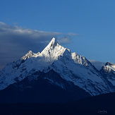
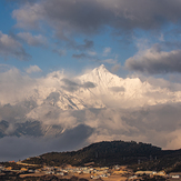
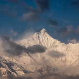
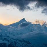 See 16 more Kawagebo or Kawagarbo (卡瓦格博) photos
Mainsum Peak
Mainsum Peak
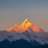
Sunrise of Kawagarbo in November
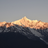
梅里雪山
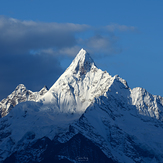
Kawagarbo
Kawagarbo
Kawagarbo
 Like us
 Follow us
