– Lat/Long: 31.98° S 70.12° W
 Mercedario
Weather Forecast, ArgentinaIssued: 1 pm Tue 11 Jun Local TimeUpdates in: hr min sUpdate imminent
MercedarioWeather Forecast, Argentina
Issued: 1 pm Tue 11 Jun Local Time
Updates in:
Update imminent hr min s

Issued: 1 pm Tue 11 Jun Local Time
Updates in:
Update imminent hr min s
Days 1–4 Weather SummaryA heavy fall of snow, heaviest during Thu afternoon. Extremely cold (max -21°C on Tue afternoon, min -31°C on Fri morning). Winds decreasing (extremely windy from the WNW on Wed night, stormy winds from the WNW by Fri morning). | Days 5–7 Weather SummaryA light covering of new snow mostly falling on Fri afternoon. Extremely cold (max -26°C on Sun night, min -29°C on Fri afternoon). Winds increasing (near gales from the W on Sat night, extremely windy from the W by Mon morning). | Days 8–10 Weather SummaryA moderate fall of snow, heaviest on Tue morning. Extremely cold (max -25°C on Thu morning, min -33°C on Tue morning). Winds decreasing (extremely windy from the W on Mon afternoon, strong winds from the W by Thu morning). | Days 11–13 Weather SummaryA light covering of new snow mostly falling on Thu night. Extremely cold (max -20°C on Sat afternoon, min -33°C on Fri morning). Winds decreasing (extremely windy from the SW on Fri afternoon, strong winds from the SW by Sat night). | |||||||||||||||||||||||||||||||||
Tue 11 | Wednesday 12 | Thursday 13 | Friday 14 | Saturday 15 | Sunday 16 | Monday 17 | Tuesday 18 | Wednesday 19 | Thursday 20 | Friday 21 | Saturday 22 | Sun 23 | ||||||||||||||||||||||||
PM | night | AM | PM | night | AM | PM | night | AM | PM | night | AM | PM | night | AM | PM | night | AM | PM | night | AM | PM | night | AM | PM | night | AM | PM | night | AM | PM | night | AM | PM | night | AM | |
light snow | cloudy | cloudy | cloudy | light snow | heavy snow | heavy snow | heavy snow | heavy snow | snow shwrs | snow shwrs | cloudy | cloudy | clear | some clouds | some clouds | some clouds | some clouds | light snow | mod. snow | mod. snow | light snow | snow shwrs | clear | clear | some clouds | some clouds | some clouds | snow shwrs | light snow | snow shwrs | clear | clear | clear | clear | some clouds | |
km/h | ||||||||||||||||||||||||||||||||||||
Wave Height Map | 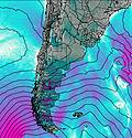 | 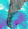 | 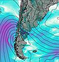 |  |  |  |  |  |  |  |  | 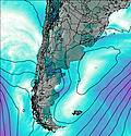 | 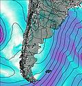 | |||||||||||||||||||||||
3 | — | — | — | 1.0 | 11 | 24 | 34 | 16 | 7 | 1.0 | — | — | — | — | — | — | — | 1.0 | 7 | 6 | 4 | 1.0 | — | — | — | — | — | 2.0 | 2.0 | 1.0 | — | — | — | — | — | |
— | — | — | — | — | — | — | — | — | — | — | — | — | — | — | — | — | — | — | — | — | — | — | — | — | — | — | — | — | — | — | — | — | — | — | — | |
max°C | -21 | -21 | -21 | -21 | -22 | -26 | -27 | -27 | -31 | -29 | -27 | -28 | -28 | -27 | -27 | -27 | -26 | -29 | -30 | -30 | -32 | -32 | -32 | -29 | -28 | -26 | -25 | -25 | -27 | -32 | -28 | -24 | -22 | -20 | -20 | -20 |
min°C | -21 | -21 | -21 | -21 | -27 | -27 | -27 | -30 | -31 | -29 | -28 | -28 | -28 | -28 | -27 | -27 | -29 | -29 | -30 | -31 | -33 | -32 | -33 | -33 | -28 | -27 | -25 | -26 | -31 | -33 | -31 | -28 | -23 | -21 | -21 | -21 |
-43 | -43 | -43 | -44 | -54 | -54 | -52 | -55 | -56 | -53 | -53 | -50 | -50 | -48 | -48 | -48 | -53 | -54 | -57 | -57 | -58 | -56 | -55 | -55 | -51 | -48 | -42 | -46 | -56 | -59 | -58 | -54 | -44 | -39 | -36 | -36 | |
3500 | 3400 | 3600 | 3350 | 2700 | 2800 | 2750 | 2400 | 2500 | 2250 | 1950 | 2900 | 2750 | 2100 | 3000 | 2650 | 2600 | 2450 | 2300 | 2050 | 2300 | 2200 | 1550 | 1950 | 1800 | 2150 | 3000 | 2900 | 2550 | 2000 | 1750 | 1800 | 2900 | 2850 | 3000 | 3700 | |
Cloud base (m) | 4950 | 6000 | 6150 | 6250 | 5400 | 4050 | 4050 | 4200 | 4250 | 4350 | 6600 | 5350 | 6600 | 5650 | 5450 | 5300 | 4200 | 4100 | 4150 | 4100 | 4650 | 7150 | 5850 | 5350 | 5100 | 5200 | 4500 | 9200 | ||||||||
— | — | 7:37 | — | — | 7:37 | — | — | 7:37 | — | — | 7:39 | — | — | 7:39 | — | — | 7:39 | — | — | 7:39 | — | — | 7:39 | — | — | 7:39 | — | — | 7:39 | — | — | 7:39 | — | — | 7:41 | |
5:42 | — | — | 5:42 | — | — | 5:42 | — | — | 5:42 | — | — | 5:43 | — | — | 5:43 | — | — | 5:43 | — | — | 5:43 | — | — | 5:43 | — | — | 5:43 | — | — | 5:44 | — | — | 5:44 | — | — | |
Mercedario Weather (Days 0-3):
The weather forecast for Mercedario is: A heavy fall of snow, heaviest during Thu afternoon. Extremely cold (max -21°C on Tue afternoon, min -31°C on Fri morning). Winds decreasing (extremely windy from the WNW on Wed night, stormy winds from the WNW by Fri morning).
Mercedario Weather (Days 3-6):
A light covering of new snow mostly falling on Fri afternoon. Extremely cold (max -26°C on Sun night, min -29°C on Fri afternoon). Winds increasing (near gales from the W on Sat night, extremely windy from the W by Mon morning).
Mercedario Weather (Days 6-9):
A moderate fall of snow, heaviest on Tue morning. Extremely cold (max -25°C on Thu morning, min -33°C on Tue morning). Winds decreasing (extremely windy from the W on Mon afternoon, strong winds from the W by Thu morning).
This table gives the weather forecast for Mercedario at the specific elevation of 6770 m. Our advanced weather models allow us to provide distinct weather forecasts for several elevations of Mercedario. To see the weather forecasts for the other elevations, use the tab navigation above the table. For a wider overview of the weather, consult the Weather Map of Argentina.
| Weather Station | Temp. | Weather | Wind | Gusts | Cloud / Visibility |
|---|---|---|---|---|---|
Llay Llay- Las Peñas | |||||
Lo Pinto | |||||
MendozaAero | |||||
Mendoz / l Plumerillo Airport |
* NOTE: not all weather observatories update at the same frequency which is the reason why some locations may show data from stations that are further away than known closer ones.
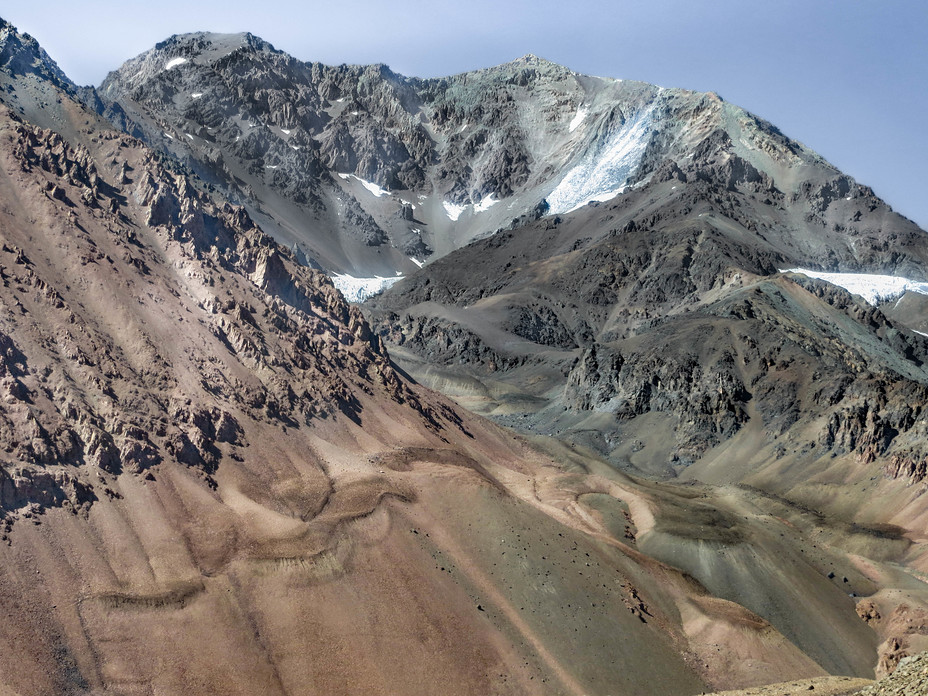
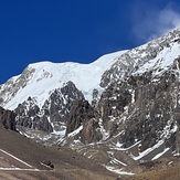
Mercedario Photos
View all
Central Argentina-Chile photos (437) |
Andes photos (904) |
photos from mountains in Argentina (227) |
all photos
 Upload new photo
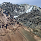
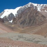
Cerro Mercedario (N)
Glaciar del Caballito
Mercedario
 Like us
 Follow us
