
– Lat/Long: 28.77° S 28.87° E
 Mont-aux-Sources
Weather Forecast, South AfricaIssued: 1 am Sat 01 Jun Local TimeUpdates in: hr min sUpdate imminent
Mont-aux-SourcesWeather Forecast, South Africa
Issued: 1 am Sat 01 Jun Local Time
Updates in:
Update imminent hr min s

Issued: 1 am Sat 01 Jun Local Time
Updates in:
Update imminent hr min s
Days 1–3 Weather SummaryA moderate fall of snow, heaviest on Sun afternoon. Freeze-thaw conditions (max 4°C on Sat afternoon, min -5°C on Mon night). Winds increasing (light winds from the N on Sun afternoon, gales from the N by Sun night). | Days 4–6 Weather SummaryMostly dry. Freeze-thaw conditions (max 5°C on Thu morning, min -3°C on Thu night). Winds decreasing (gales from the NW on Thu afternoon, light winds from the SW by Thu night). | |||||||||||||||||
Saturday 1 | Sunday 2 | Monday 3 | Tuesday 4 | Wednesday 5 | Thursday 6 | |||||||||||||
AM | PM | night | AM | PM | night | AM | PM | night | AM | PM | night | AM | PM | night | AM | PM | night | |
clear | clear | some clouds | clear | light snow | light snow | light snow | snow shwrs | clear | clear | clear | clear | clear | clear | clear | some clouds | some clouds | clear | |
km/h | ||||||||||||||||||
Wave Height Map | 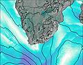 |  | 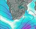 | 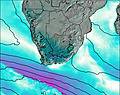 | 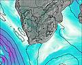 | 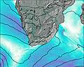 | ||||||||||||
— | — | — | — | 5 | 5 | 3 | 1.0 | — | — | — | — | — | — | — | — | — | — | |
— | — | — | — | — | — | — | — | — | — | — | — | — | — | — | — | — | — | |
max°C | 3 | 4 | 3 | 2 | 1 | 1 | 1 | -2 | -1 | 0 | 3 | 4 | 4 | 4 | 4 | 5 | 4 | 2 |
min°C | 2 | 4 | 3 | 2 | 0 | 0 | -1 | -4 | -5 | 0 | 2 | 3 | 4 | 4 | 4 | 4 | 3 | -3 |
-4 | -1 | -2 | -3 | -5 | -7 | -10 | -13 | -15 | -8 | -5 | -2 | -1 | -1 | -2 | -3 | -4 | -8 | |
3750 | 3950 | 3700 | 3600 | 3300 | 3450 | 3150 | 2650 | 2500 | 3350 | 3750 | 3850 | 3850 | 3950 | 4000 | 3900 | 3800 | 3050 | |
Cloud base (m) | 3650 | 3750 | 2850 | 2800 | 2800 | 2950 | 5300 | 5150 | ||||||||||
6:50 | — | — | 6:50 | — | — | 6:50 | — | — | 6:50 | — | — | 6:50 | — | — | 6:52 | — | — | |
— | 5:14 | — | — | 5:14 | — | — | 5:14 | — | — | 5:14 | — | — | 5:14 | — | — | 5:14 | — | |
Mont-aux-Sources Weather (Days 0-3):
The weather forecast for Mont-aux-Sources is: A moderate fall of snow, heaviest on Sun afternoon. Freeze-thaw conditions (max 4°C on Sat afternoon, min -5°C on Mon night). Winds increasing (light winds from the N on Sun afternoon, gales from the N by Sun night).
Mont-aux-Sources Weather (Days 3-6):
Mostly dry. Freeze-thaw conditions (max 5°C on Thu morning, min -3°C on Thu night). Winds decreasing (gales from the NW on Thu afternoon, light winds from the SW by Thu night).
This table gives the weather forecast for Mont-aux-Sources at the specific elevation of 3282 m. Our advanced weather models allow us to provide distinct weather forecasts for several elevations of Mont-aux-Sources. To see the weather forecasts for the other elevations, use the tab navigation above the table. For a wider overview of the weather, consult the Weather Map of South Africa.
| Weather Station | Temp. | Weather | Wind | Gusts | Cloud / Visibility |
|---|---|---|---|---|---|
RoyalNationalPark | |||||
Van Reenen | |||||
Van Reenen | |||||
Bethlehem | |||||
* NOTE: not all weather observatories update at the same frequency which is the reason why some locations may show data from stations that are further away than known closer ones.
 Like us
 Follow us
