– Lat/Long: 47.96° N 121.33° W
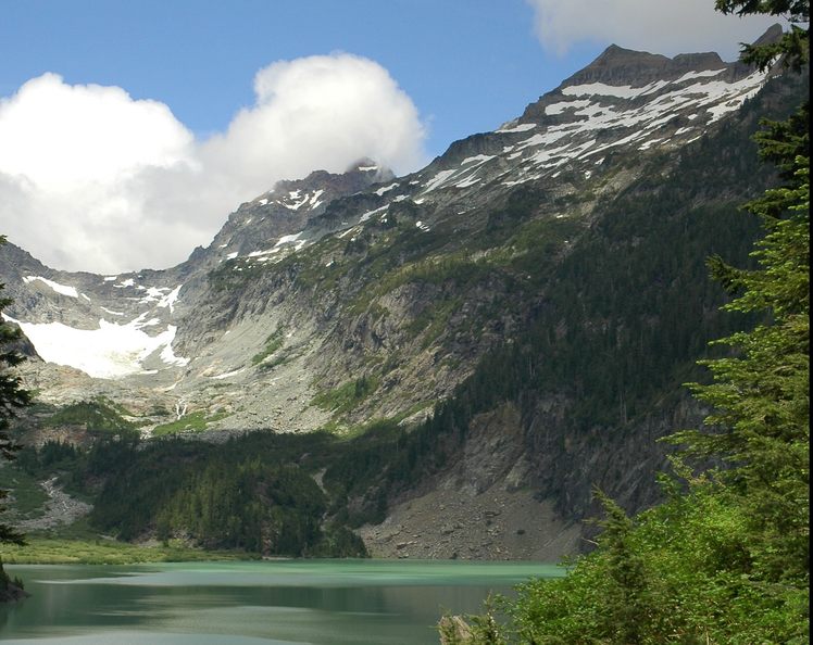
 Kyes Peak
Weather Forecast, United StatesIssued: 4 pm Sun 02 Jun Local TimeUpdates in: hr min sUpdate imminent
Kyes PeakWeather Forecast, United States
Issued: 4 pm Sun 02 Jun Local Time
Updates in:
Update imminent hr min s

Issued: 4 pm Sun 02 Jun Local Time
Updates in:
Update imminent hr min s
Days 1–4 Weather SummaryHeavy rain (total 44mm) on Sun night. Becoming colder with heavy fall of snow, heaviest during Mon morning. Freeze-thaw conditions (max 5°C on Sun afternoon, min -1°C on Mon morning). Wind will be generally light. | Days 5–7 Weather SummaryMostly dry. Warm (max 20°C on Fri afternoon, min 6°C on Wed afternoon). Wind will be generally light. | Days 8–10 Weather SummaryLight rain (total 8mm), mostly falling on Sat night. Warm (max 21°C on Sat afternoon, min 1°C on Sun night). Wind will be generally light. | Days 11–13 Weather SummaryMostly dry. Freeze-thaw conditions (max 15°C on Tue afternoon, min 0°C on Thu night). Wind will be generally light. | |||||||||||||||||||||||||||||||||
Sun 2 | Monday 3 | Tuesday 4 | Wednesday 5 | Thursday 6 | Friday 7 | Saturday 8 | Sunday 9 | Monday 10 | Tuesday 11 | Wednesday 12 | Thursday 13 | Fri 14 | ||||||||||||||||||||||||
PM | night | AM | PM | night | AM | PM | night | AM | PM | night | AM | PM | night | AM | PM | night | AM | PM | night | AM | PM | night | AM | PM | night | AM | PM | night | AM | PM | night | AM | PM | night | AM | |
heavy rain | light snow | mod. snow | mod. snow | light snow | light rain | light rain | rain shwrs | rain shwrs | clear | clear | clear | clear | clear | clear | clear | clear | clear | rain shwrs | rain shwrs | rain shwrs | rain shwrs | rain shwrs | light rain | rain shwrs | clear | clear | clear | some clouds | some clouds | some clouds | rain shwrs | some clouds | rain shwrs | some clouds | cloudy | |
km/h | ||||||||||||||||||||||||||||||||||||
Wave Height Map |  |  |  |  | 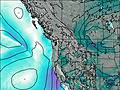 | 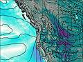 | 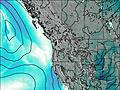 | 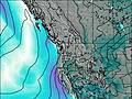 | 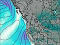 |  | 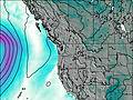 | 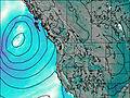 | 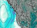 | |||||||||||||||||||||||
— | 1.0 | 9 | 6 | 4 | — | — | — | — | — | — | — | — | — | — | — | — | — | — | — | — | — | — | — | — | — | — | — | — | — | — | — | — | — | — | — | |
12 | 23 | — | — | — | 4 | 5 | 0.8 | 0.1 | — | — | — | — | — | — | — | — | — | 0.2 | 4 | 0.1 | 0.9 | 2.0 | 0.1 | 0.4 | — | — | — | — | — | — | 0.2 | — | 0.2 | — | — | |
max°C | 5 | 4 | 0 | 1 | 1 | 3 | 3 | 2 | 2 | 8 | 7 | 9 | 13 | 12 | 16 | 20 | 19 | 20 | 21 | 14 | 10 | 10 | 6 | 3 | 6 | 7 | 12 | 15 | 13 | 14 | 15 | 11 | 1 | 6 | 4 | 1 |
min°C | 5 | 2 | -1 | 0 | 0 | 3 | 3 | 0 | 0 | 6 | 6 | 7 | 12 | 11 | 13 | 20 | 18 | 18 | 19 | 9 | 8 | 7 | 1 | 2 | 4 | 6 | 8 | 15 | 12 | 12 | 14 | 1 | 1 | 4 | 0 | 0 |
3 | 0 | -5 | -4 | -3 | -1 | -1 | -3 | 0 | 5 | 5 | 7 | 12 | 11 | 13 | 20 | 18 | 18 | 19 | 8 | 7 | 5 | -2 | 0 | 2 | 5 | 7 | 14 | 12 | 12 | 13 | -2 | -2 | 0 | -3 | -3 | |
2400 | 1950 | 1350 | 1650 | 1500 | 2000 | 2000 | 1500 | 2500 | 2950 | 3300 | 3250 | 3550 | 4000 | 4000 | 4200 | 4300 | 4300 | 4300 | 4150 | 3500 | 2650 | 2000 | 3300 | 3800 | 4000 | 3850 | 4000 | 4100 | 3850 | 3600 | 2400 | 1700 | 2300 | 1600 | 2200 | |
Cloud base (m) | 800 | 800 | 850 | 850 | 850 | 850 | 900 | 950 | 950 | 1700 | 5800 | 5850 | 9800 | 7900 | 9100 | 850 | 5400 | 1900 | 900 | 900 | 1600 | 6750 | 900 | 900 | 1900 | 900 | 950 | |||||||||
— | — | 5:07 | — | — | 5:07 | — | — | 5:07 | — | — | 5:07 | — | — | 5:05 | — | — | 5:05 | — | — | 5:05 | — | — | 5:05 | — | — | 5:05 | — | — | 5:05 | — | — | 5:05 | — | — | 5:05 | |
— | 8:58 | — | — | 8:59 | — | — | 8:59 | — | — | 9:00 | — | — | 9:00 | — | — | 9:01 | — | — | 9:01 | — | — | 9:02 | — | — | 9:04 | — | — | 9:04 | — | — | 9:05 | — | — | 9:05 | — | |
Kyes Peak Weather (Days 0-3):
The weather forecast for Kyes Peak is: Heavy rain (total 44mm) on Sun night. Becoming colder with heavy fall of snow, heaviest during Mon morning. Freeze-thaw conditions (max 5°C on Sun afternoon, min -1°C on Mon morning). Wind will be generally light.
Kyes Peak Weather (Days 3-6):
Mostly dry. Warm (max 20°C on Fri afternoon, min 6°C on Wed afternoon). Wind will be generally light.
Kyes Peak Weather (Days 6-9):
Light rain (total 8mm), mostly falling on Sat night. Warm (max 21°C on Sat afternoon, min 1°C on Sun night). Wind will be generally light.
This table gives the weather forecast for Kyes Peak at the specific elevation of 1500 m. Our advanced weather models allow us to provide distinct weather forecasts for several elevations of Kyes Peak. To see the weather forecasts for the other elevations, use the tab navigation above the table. For a wider overview of the weather, consult the Weather Map of Washington.
 Like us
 Follow us
