
– Lat/Long: 44.38° N 121.93° W
 Sand Mountain
Weather Forecast, United StatesIssued: 4 am Mon 20 May Local TimeUpdates in: hr min sUpdate imminent
Sand MountainWeather Forecast, United States
Issued: 4 am Mon 20 May Local Time
Updates in:
Update imminent hr min s

Issued: 4 am Mon 20 May Local Time
Updates in:
Update imminent hr min s
Days 1–3 Weather SummaryModerate rain (total 11mm) heaviest on Tue night, then becoming colder with a dusting of snow on Tue night. Freeze-thaw conditions (max 7°C on Mon afternoon, min -2°C on Wed morning). Winds decreasing (strong winds from the W on Wed morning, calm by Wed night). | Days 4–6 Weather SummaryA light covering of new snow mostly falling on Fri afternoon. Freeze-thaw conditions (max 9°C on Thu afternoon, min -3°C on Fri night). Winds increasing (calm on Thu morning, fresh winds from the W by Fri night). | |||||||||||||||||
Monday 20 | Tuesday 21 | Wednesday 22 | Thursday 23 | Friday 24 | Saturday 25 | |||||||||||||
AM | PM | night | AM | PM | night | AM | PM | night | AM | PM | night | AM | PM | night | AM | PM | night | |
some clouds | clear | some clouds | some clouds | light rain | light snow | light snow | light snow | some clouds | some clouds | clear | some clouds | cloudy | light snow | light snow | cloudy | rain shwrs | some clouds | |
km/h | ||||||||||||||||||
Wave Height Map | 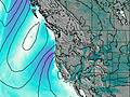 | 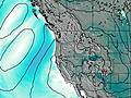 | 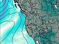 | 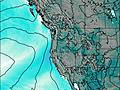 |  |  | ||||||||||||
— | — | — | — | — | 1.0 | 2.0 | 1.0 | — | — | — | — | — | 3 | 4 | — | — | — | |
— | — | — | — | 2 | 8 | — | — | — | — | — | — | — | — | — | — | 0.1 | — | |
max°C | 4 | 7 | 4 | 4 | 7 | 4 | -1 | 0 | 0 | 4 | 9 | 7 | 3 | 0 | -1 | -1 | 3 | 3 |
min°C | -1 | 7 | 1 | 1 | 4 | 1 | -2 | -1 | -1 | 0 | 8 | 4 | 2 | 0 | -3 | -3 | 2 | 2 |
-3 | 4 | -2 | -2 | -1 | -6 | -10 | -8 | -6 | -2 | 6 | 1 | -3 | -6 | -10 | -7 | -2 | -1 | |
2200 | 2450 | 2200 | 2600 | 2500 | 2050 | 1450 | 1650 | 1350 | 2400 | 2750 | 2800 | 2050 | 1700 | 1150 | 1450 | 2500 | 2700 | |
Cloud base (m) | 950 | 2650 | 950 | 1500 | 1600 | 800 | 850 | 850 | 850 | 1550 | 2200 | 5800 | 2000 | 800 | 850 | 850 | 1500 | 1600 |
5:33 | — | — | 5:33 | — | — | 5:33 | — | — | 5:31 | — | — | 5:31 | — | — | 5:30 | — | — | |
— | — | 8:34 | — | — | 8:35 | — | — | 8:36 | — | — | 8:37 | — | — | 8:37 | — | — | 8:38 | |
Sand Mountain Weather (Days 0-3):
The weather forecast for Sand Mountain is: Moderate rain (total 11mm) heaviest on Tue night, then becoming colder with a dusting of snow on Tue night. Freeze-thaw conditions (max 7°C on Mon afternoon, min -2°C on Wed morning). Winds decreasing (strong winds from the W on Wed morning, calm by Wed night).
Sand Mountain Weather (Days 3-6):
A light covering of new snow mostly falling on Fri afternoon. Freeze-thaw conditions (max 9°C on Thu afternoon, min -3°C on Fri night). Winds increasing (calm on Thu morning, fresh winds from the W by Fri night).
This table gives the weather forecast for Sand Mountain at the specific elevation of 1664 m. Our advanced weather models allow us to provide distinct weather forecasts for several elevations of Sand Mountain. To see the weather forecasts for the other elevations, use the tab navigation above the table. For a wider overview of the weather, consult the Weather Map of Oregon.
 Like us
 Follow us
