
– Lat/Long: 43.86° N 110.85° W
 Window Peak
Weather Forecast, United StatesIssued: 11 pm Sun 02 Jun Local TimeUpdates in: hr min sUpdate imminent
Window PeakWeather Forecast, United States
Issued: 11 pm Sun 02 Jun Local Time
Updates in:
Update imminent hr min s

Issued: 11 pm Sun 02 Jun Local Time
Updates in:
Update imminent hr min s
Days 1–4 Weather SummaryModerate rain (total 14mm), heaviest on Mon afternoon. Very mild (max 17°C on Wed afternoon, min 4°C on Mon night). Mainly strong winds. | Days 5–7 Weather SummaryLight rain (total 5mm), mostly falling on Fri night. Warm (max 23°C on Fri afternoon, min 12°C on Wed night). Wind will be generally light. | ||||||||||||||||||
Monday 3 | Tuesday 4 | Wednesday 5 | Thursday 6 | Friday 7 | Saturday 8 | ||||||||||||||
night | AM | PM | night | AM | PM | night | AM | PM | night | AM | PM | night | AM | PM | night | AM | PM | night | |
light rain | light rain | mod. rain | rain shwrs | some clouds | rain shwrs | rain shwrs | clear | clear | clear | clear | some clouds | some clouds | clear | clear | risk tstorm | clear | clear | clear | |
km/h | |||||||||||||||||||
Wave Height Map | 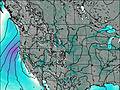 | 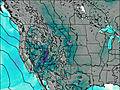 | 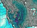 | 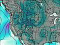 | 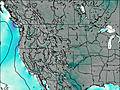 | 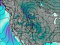 | 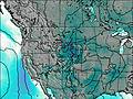 | ||||||||||||
— | — | — | — | — | — | — | — | — | — | — | — | — | — | — | — | — | — | — | |
0.5 | 3 | 8 | 1.6 | — | 0.3 | 0.4 | — | — | — | — | — | — | — | — | 5 | — | — | — | |
max°C | 12 | 9 | 9 | 8 | 10 | 13 | 11 | 15 | 17 | 14 | 19 | 21 | 18 | 22 | 23 | 19 | 20 | 22 | 19 |
min°C | 9 | 9 | 8 | 4 | 7 | 13 | 10 | 12 | 16 | 12 | 16 | 21 | 15 | 19 | 23 | 14 | 17 | 22 | 16 |
6 | 5 | 4 | -1 | 3 | 10 | 7 | 9 | 14 | 12 | 16 | 21 | 15 | 19 | 23 | 14 | 17 | 22 | 16 | |
3900 | 3400 | 3350 | 2950 | 2950 | 3800 | 3950 | 3750 | 4350 | 4550 | 4550 | 4750 | 4750 | 4700 | 4950 | 4850 | 4700 | 4900 | 4950 | |
Cloud base (m) | 3650 | 2600 | 2600 | 2700 | 3050 | 3400 | 3250 | 3000 | 8900 | 6400 | 5300 | 5000 | 6750 | 4800 | |||||
— | 5:41 | — | — | 5:41 | — | — | 5:41 | — | — | 5:41 | — | — | 5:41 | — | — | 5:41 | — | — | |
— | — | — | 9:00 | — | — | 9:00 | — | — | 9:01 | — | — | 9:02 | — | — | 9:02 | — | — | 9:04 | |
Window Peak Weather (Days 0-3):
The weather forecast for Window Peak is: Moderate rain (total 14mm), heaviest on Mon afternoon. Very mild (max 17°C on Wed afternoon, min 4°C on Mon night). Mainly strong winds.
Window Peak Weather (Days 3-6):
Light rain (total 5mm), mostly falling on Fri night. Warm (max 23°C on Fri afternoon, min 12°C on Wed night). Wind will be generally light.
This table gives the weather forecast for Window Peak at the specific elevation of 2000 m. Our advanced weather models allow us to provide distinct weather forecasts for several elevations of Window Peak. To see the weather forecasts for the other elevations, use the tab navigation above the table. For a wider overview of the weather, consult the Weather Map of Wyoming.
| Weather Station | Temp. | Weather | Wind | Gusts | Cloud / Visibility |
|---|---|---|---|---|---|
Jackson Airport | |||||
* NOTE: not all weather observatories update at the same frequency which is the reason why some locations may show data from stations that are further away than known closer ones.
 Like us
 Follow us
