
– Lat/Long: 48.47° N 113.35° W
 Appistoki Peak
Weather Forecast, United StatesIssued: 5 pm Wed 08 May Local TimeUpdates in: hr min sUpdate imminent
Appistoki PeakWeather Forecast, United States
Issued: 5 pm Wed 08 May Local Time
Updates in:
Update imminent hr min s

Issued: 5 pm Wed 08 May Local Time
Updates in:
Update imminent hr min s
Days 1–4 Weather SummaryA light covering of new snow mostly falling on Wed afternoon. Freeze-thaw conditions (max 9°C on Fri afternoon, min -2°C on Wed afternoon). Wind will be generally light. | Days 5–7 Weather SummaryDrizzle on Sun night turning to light snow on Tue morning. Freeze-thaw conditions (max 8°C on Sat afternoon, min -1°C on Tue morning). Winds decreasing (near gales from the W on Sun night, light winds from the NNW by Tue morning). | Days 8–10 Weather SummaryDrizzle, on Wed night followed by colder weather and a moderate fall of snow, heaviest on Wed night.. Freeze-thaw conditions (max 4°C on Wed afternoon, min -6°C on Thu night). Winds increasing (light winds from the W on Tue night, stormy winds from the W by Thu night). | Days 11–13 Weather SummaryMostly dry. Freeze-thaw conditions (max 9°C on Mon afternoon, min -3°C on Fri night). Winds increasing (light winds from the SW on Fri night, strong winds from the W by Sat night). | |||||||||||||||||||||||||||||||||
Wed 8 | Thursday 9 | Friday 10 | Saturday 11 | Sunday 12 | Monday 13 | Tuesday 14 | Wednesday 15 | Thursday 16 | Friday 17 | Saturday 18 | Sunday 19 | Mon 20 | ||||||||||||||||||||||||
PM | night | AM | PM | night | AM | PM | night | AM | PM | night | AM | PM | night | AM | PM | night | AM | PM | night | AM | PM | night | AM | PM | night | AM | PM | night | AM | PM | night | AM | PM | night | AM | |
light snow | light snow | some clouds | rain shwrs | clear | clear | clear | clear | clear | some clouds | rain shwrs | clear | clear | rain shwrs | some clouds | some clouds | light snow | light snow | light snow | some clouds | clear | some clouds | snow shwrs | snow shwrs | snow shwrs | snow shwrs | clear | clear | cloudy | cloudy | some clouds | some clouds | some clouds | some clouds | clear | clear | |
km/h | ||||||||||||||||||||||||||||||||||||
Wave Height Map |  |  |  |  | 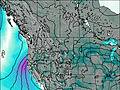 | 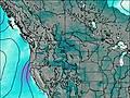 | 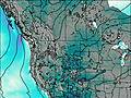 | 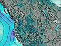 | 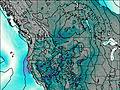 | 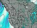 | 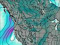 | 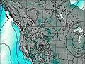 | 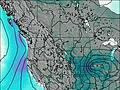 | |||||||||||||||||||||||
4 | 1.0 | — | — | — | — | — | — | — | — | — | — | — | — | — | — | 2.0 | 4 | 1.0 | — | — | — | 8 | 4 | 1.0 | 1.0 | — | — | — | — | — | — | — | — | — | — | |
— | — | — | 0.1 | — | — | — | — | — | — | 0.4 | — | — | 1.0 | — | — | — | — | — | — | — | — | 1.4 | — | — | — | — | — | — | — | — | — | — | — | — | — | |
max°C | -2 | -1 | 1 | 4 | 2 | 7 | 9 | 7 | 7 | 8 | 6 | 7 | 8 | 6 | 1 | 1 | 1 | -1 | 1 | 1 | 2 | 4 | 3 | -2 | -2 | -5 | -2 | 1 | 0 | -1 | 1 | 0 | 3 | 6 | 4 | 7 |
min°C | -2 | -1 | 0 | 2 | 2 | 5 | 8 | 5 | 6 | 8 | 5 | 6 | 8 | 1 | 1 | 1 | 0 | -1 | 1 | -1 | 1 | 3 | 0 | -3 | -4 | -6 | -3 | 0 | -3 | -2 | 0 | -1 | 2 | 5 | 3 | 5 |
-9 | -6 | -3 | 0 | 0 | 4 | 5 | 1 | 4 | 5 | 0 | 0 | 3 | -7 | -7 | -5 | -4 | -3 | -3 | -5 | -4 | -3 | -9 | -14 | -15 | -18 | -13 | -7 | -8 | -6 | -6 | -9 | -5 | 0 | -4 | 0 | |
2000 | 2200 | 2450 | 2850 | 3450 | 3550 | 3800 | 3800 | 3500 | 3400 | 3450 | 3400 | 3500 | 3050 | 2650 | 2650 | 2600 | 2350 | 2650 | 2550 | 2600 | 2800 | 2900 | 2250 | 2250 | 1650 | 2050 | 2500 | 2200 | 2200 | 2550 | 2250 | 2900 | 3000 | 3250 | 3200 | |
Cloud base (m) | 1750 | 1750 | 2100 | 1900 | 1900 | 8950 | 6800 | 3200 | 3300 | 2050 | 2100 | 1850 | 1750 | 1800 | 2650 | 2200 | 2850 | 2400 | 1750 | 2650 | 2250 | 1850 | 1800 | 2500 | 2450 | 6900 | 3050 | 3100 | 3150 | |||||||
— | — | 6:00 | — | — | 5:58 | — | — | 5:56 | — | — | 5:56 | — | — | 5:54 | — | — | 5:52 | — | — | 5:52 | — | — | 5:50 | — | — | 5:48 | — | — | 5:48 | — | — | 5:47 | — | — | 5:46 | |
8:58 | — | — | — | 9:00 | — | — | 9:00 | — | — | 9:01 | — | — | 9:04 | — | — | 9:05 | — | — | 9:06 | — | — | 9:07 | — | — | 9:08 | — | — | 9:09 | — | — | 9:10 | — | — | 9:13 | — | |
Appistoki Peak Weather (Days 0-3):
The weather forecast for Appistoki Peak is: A light covering of new snow mostly falling on Wed afternoon. Freeze-thaw conditions (max 9°C on Fri afternoon, min -2°C on Wed afternoon). Wind will be generally light.
Appistoki Peak Weather (Days 3-6):
Drizzle on Sun night turning to light snow on Tue morning. Freeze-thaw conditions (max 8°C on Sat afternoon, min -1°C on Tue morning). Winds decreasing (near gales from the W on Sun night, light winds from the NNW by Tue morning).
Appistoki Peak Weather (Days 6-9):
Drizzle, on Wed night followed by colder weather and a moderate fall of snow, heaviest on Wed night.. Freeze-thaw conditions (max 4°C on Wed afternoon, min -6°C on Thu night). Winds increasing (light winds from the W on Tue night, stormy winds from the W by Thu night).
This table gives the weather forecast for Appistoki Peak at the specific elevation of 2488 m. Our advanced weather models allow us to provide distinct weather forecasts for several elevations of Appistoki Peak. To see the weather forecasts for the other elevations, use the tab navigation above the table. For a wider overview of the weather, consult the Weather Map of Montana.
 Like us
 Follow us
