– Lat/Long: 28.70° N 83.50° E
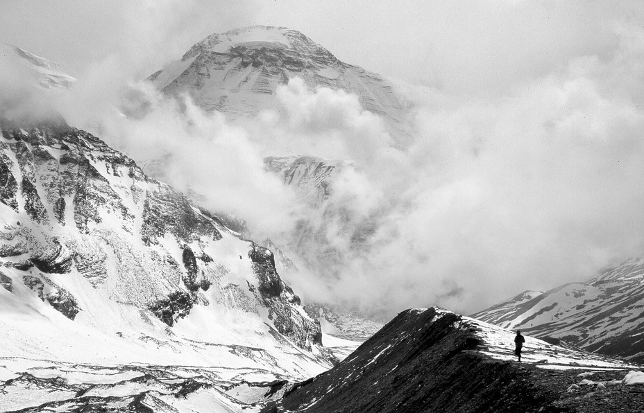
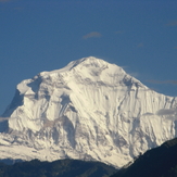
 Dhaulagiri
Weather Forecast, NepalIssued: 10 am Wed 01 May Local TimeUpdates in: hr min sUpdate imminent
DhaulagiriWeather Forecast, Nepal
Issued: 10 am Wed 01 May Local Time
Updates in:
Update imminent hr min s

Issued: 10 am Wed 01 May Local Time
Updates in:
Update imminent hr min s
Days 1–3 Weather SummaryMostly dry. Temperatures will be well below freezing (max -10°C on Fri afternoon, min -21°C on Wed night). Winds decreasing (near gales from the WSW on Wed morning, light winds from the WNW by Fri night). | Days 4–6 Weather SummaryA heavy fall of snow, heaviest during Mon afternoon. Temperatures will be well below freezing (max -10°C on Sat morning, min -17°C on Sun night). Winds decreasing (near gales from the WNW on Sat night, light winds from the NE by Mon night). | Days 7–9 Weather SummaryA moderate fall of snow, heaviest on Tue afternoon. Temperatures will be well below freezing (max -10°C on Wed night, min -14°C on Tue morning). Wind will be generally light. | Days 10–12 Weather SummaryA heavy fall of snow, heaviest during Sun night. Temperatures will be well below freezing (max -9°C on Sat afternoon, min -11°C on Fri morning). Wind will be generally light. | |||||||||||||||||||||||||||||||||
Wednesday 1 | Thursday 2 | Friday 3 | Saturday 4 | Sunday 5 | Monday 6 | Tuesday 7 | Wednesday 8 | Thursday 9 | Friday 10 | Saturday 11 | Sunday 12 | |||||||||||||||||||||||||
AM | PM | night | AM | PM | night | AM | PM | night | AM | PM | night | AM | PM | night | AM | PM | night | AM | PM | night | AM | PM | night | AM | PM | night | AM | PM | night | AM | PM | night | AM | PM | night | |
some clouds | clear | clear | clear | clear | clear | clear | some clouds | clear | clear | some clouds | clear | some clouds | heavy snow | snow shwrs | snow shwrs | heavy snow | snow shwrs | light snow | mod. snow | snow shwrs | snow shwrs | light snow | clear | snow shwrs | light snow | some clouds | snow shwrs | light snow | some clouds | snow shwrs | mod. snow | some clouds | snow shwrs | light snow | heavy snow | |
km/h | ||||||||||||||||||||||||||||||||||||
Wave Height Map |  |  |  |  |  |  |  |  |  |  |  |  | ||||||||||||||||||||||||
— | — | — | — | — | — | — | — | — | — | — | — | — | 11 | 3 | 1.0 | 30 | 2.0 | 1.0 | 7 | 1.0 | 1.0 | 5 | — | 1.0 | 3 | — | 1.0 | 2.0 | — | 2.0 | 6 | — | 1.0 | 3 | 15 | |
— | — | — | — | — | — | — | — | — | — | — | — | — | — | — | — | — | — | — | — | — | — | — | — | — | — | — | — | — | — | — | — | — | — | — | — | |
max°C | -18 | -19 | -20 | -18 | -17 | -14 | -11 | -10 | -10 | -10 | -12 | -14 | -14 | -14 | -15 | -15 | -13 | -14 | -13 | -12 | -12 | -11 | -11 | -10 | -11 | -11 | -10 | -10 | -10 | -10 | -10 | -9 | -10 | -9 | -9 | -9 |
min°C | -19 | -20 | -21 | -20 | -18 | -16 | -12 | -10 | -11 | -10 | -14 | -15 | -14 | -14 | -17 | -16 | -14 | -14 | -14 | -12 | -13 | -12 | -11 | -13 | -12 | -11 | -12 | -11 | -11 | -11 | -11 | -9 | -10 | -10 | -9 | -10 |
-34 | -35 | -37 | -32 | -29 | -30 | -23 | -20 | -18 | -21 | -27 | -29 | -27 | -24 | -25 | -23 | -22 | -22 | -19 | -17 | -20 | -18 | -14 | -20 | -12 | -16 | -16 | -14 | -15 | -16 | -16 | -9 | -14 | -13 | -12 | -18 | |
4200 | 3850 | 2950 | 4150 | 4150 | 3950 | 4900 | 4850 | 4450 | 4950 | 4550 | 3900 | 4750 | 4400 | 4100 | 4600 | 4250 | 4200 | 4550 | 4600 | 4450 | 4750 | 4700 | 4150 | 4700 | 4650 | 4400 | 4800 | 4800 | 4500 | 4900 | 4950 | 4750 | 4950 | 5000 | 4900 | |
Cloud base (m) | 6050 | 6750 | 6450 | 9200 | 7200 | 6050 | 5750 | 5400 | 5350 | 5350 | 5350 | 6300 | 6150 | 5150 | 5200 | 5250 | 5150 | 5300 | 5150 | 5150 | 5150 | 5150 | 5150 | 5400 | 5200 | 5150 | 5200 | 5200 | 5150 | 5150 | ||||||
5:28 | — | — | 5:28 | — | — | 5:26 | — | — | 5:26 | — | — | 5:26 | — | — | 5:24 | — | — | 5:24 | — | — | 5:24 | — | — | 5:22 | — | — | 5:22 | — | — | 5:22 | — | — | 5:20 | — | — | |
— | 6:45 | — | — | 6:46 | — | — | 6:47 | — | — | 6:47 | — | — | 6:49 | — | — | 6:49 | — | — | 6:50 | — | — | 6:51 | — | — | 6:51 | — | — | 6:52 | — | — | 6:52 | — | — | 6:52 | — | |
Dhaulagiri Weather (Days 0-3):
The weather forecast for Dhaulagiri is: Mostly dry. Temperatures will be well below freezing (max -10°C on Fri afternoon, min -21°C on Wed night). Winds decreasing (near gales from the WSW on Wed morning, light winds from the WNW by Fri night).
Dhaulagiri Weather (Days 3-6):
A heavy fall of snow, heaviest during Mon afternoon. Temperatures will be well below freezing (max -10°C on Sat morning, min -17°C on Sun night). Winds decreasing (near gales from the WNW on Sat night, light winds from the NE by Mon night).
Dhaulagiri Weather (Days 6-9):
A moderate fall of snow, heaviest on Tue afternoon. Temperatures will be well below freezing (max -10°C on Wed night, min -14°C on Tue morning). Wind will be generally light.
This table gives the weather forecast for Dhaulagiri at the specific elevation of 6500 m. Our advanced weather models allow us to provide distinct weather forecasts for several elevations of Dhaulagiri. To see the weather forecasts for the other elevations, use the tab navigation above the table. For a wider overview of the weather, consult the Weather Map of Nepal.
Dhaulagiri Photos
View all
Western Nepal Himalaya photos (4) |
Greater Himalaya photos (191) |
photos from mountains in Nepal (166) |
all photos
 Upload new photo
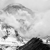

Dhaulagiri
Dhaulagiri from basecamp
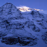
Dhaulagiri Glacier
Dhaula Jump
Dhaulagiri
 Like us
 Follow us
