– Lat/Long: 67.88° N 18.55° E
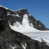
 Kebnekaise
Weather Forecast, SwedenIssued: 1 pm Sun 05 May Local TimeUpdates in: hr min sUpdate imminent
KebnekaiseWeather Forecast, Sweden
Issued: 1 pm Sun 05 May Local Time
Updates in:
Update imminent hr min s

Issued: 1 pm Sun 05 May Local Time
Updates in:
Update imminent hr min s
Days 1–4 Weather SummaryA dusting of new snow. Temperatures will be well below freezing (max -7°C on Sun afternoon, min -11°C on Sun night). Wind will be generally light. | Days 5–7 Weather SummaryA dusting of new snow. Temperatures will be below freezing (max -3°C on Thu afternoon, min -8°C on Fri morning). Wind will be generally light. | Days 8–10 Weather SummaryA dusting of new snow. Freeze-thaw conditions (max 2°C on Mon night, min -7°C on Tue morning). Winds increasing (light winds from the W on Mon morning, strong winds from the W by Tue morning). | Days 11–13 Weather SummaryMostly dry. Temperatures will be well below freezing (max -6°C on Tue afternoon, min -10°C on Thu night). Winds decreasing (fresh winds from the W on Tue afternoon, light winds from the WNW by Wed night). | |||||||||||||||||||||||||||||||||
Sun 5 | Monday 6 | Tuesday 7 | Wednesday 8 | Thursday 9 | Friday 10 | Saturday 11 | Sunday 12 | Monday 13 | Tuesday 14 | Wednesday 15 | Thursday 16 | Fri 17 | ||||||||||||||||||||||||
PM | night | AM | PM | night | AM | PM | night | AM | PM | night | AM | PM | night | AM | PM | night | AM | PM | night | AM | PM | night | AM | PM | night | AM | PM | night | AM | PM | night | AM | PM | night | AM | |
cloudy | light snow | cloudy | some clouds | some clouds | some clouds | some clouds | some clouds | some clouds | some clouds | cloudy | cloudy | cloudy | snow shwrs | some clouds | some clouds | some clouds | some clouds | some clouds | some clouds | cloudy | cloudy | cloudy | cloudy | cloudy | light snow | cloudy | cloudy | cloudy | cloudy | some clouds | some clouds | some clouds | some clouds | cloudy | cloudy | |
km/h | ||||||||||||||||||||||||||||||||||||
Wave Height Map |  |  |  |  |  |  |  |  |  |  |  |  |  | |||||||||||||||||||||||
— | 1.0 | — | — | — | — | — | — | — | — | — | — | — | 1.0 | — | — | — | — | — | — | — | — | — | — | — | 1.0 | — | — | — | — | — | — | — | — | — | — | |
— | — | — | — | — | — | — | — | — | — | — | — | — | — | — | — | — | — | — | — | — | — | — | — | — | 0.1 | — | — | — | — | — | — | — | — | — | — | |
max°C | -7 | -8 | -10 | -7 | -7 | -11 | -10 | -10 | -9 | -6 | -5 | -4 | -3 | -4 | -7 | -6 | -7 | -7 | -5 | 0 | 1 | 1 | -1 | -2 | 1 | 2 | -7 | -6 | -7 | -7 | -6 | -7 | -6 | -6 | -7 | -9 |
min°C | -7 | -11 | -10 | -8 | -11 | -11 | -10 | -11 | -10 | -7 | -5 | -5 | -4 | -7 | -8 | -7 | -8 | -8 | -5 | -4 | 0 | 1 | -2 | -2 | 0 | -6 | -7 | -6 | -8 | -7 | -6 | -7 | -7 | -6 | -10 | -10 |
-7 | -15 | -13 | -8 | -16 | -16 | -15 | -18 | -16 | -11 | -9 | -10 | -9 | -14 | -16 | -15 | -15 | -14 | -11 | -10 | -5 | -4 | -6 | -5 | -3 | -15 | -17 | -15 | -15 | -13 | -12 | -12 | -12 | -11 | -16 | -16 | |
500 | 0 | 150 | 450 | 0 | 0 | 0 | 0 | 250 | 600 | 0 | 800 | 1000 | 0 | 500 | 650 | 0 | 450 | 750 | 750 | 1750 | 1650 | 1200 | 1200 | 1800 | 700 | 450 | 600 | 250 | 550 | 650 | 250 | 650 | 600 | 0 | 250 | |
Cloud base (m) | 800 | 800 | 800 | 800 | 800 | 850 | 850 | 850 | 800 | 850 | 1750 | 900 | 800 | 800 | 850 | 1500 | 800 | 800 | 900 | 1750 | 800 | 800 | 800 | 800 | 850 | 750 | 750 | 750 | 750 | 750 | 1450 | 850 | 800 | 1450 | 800 | 800 |
— | — | 3:18 | — | — | 3:14 | — | — | 3:09 | — | — | 3:03 | — | — | 2:59 | — | — | 2:54 | — | — | 2:48 | — | — | 2:44 | — | — | 2:38 | — | — | 2:32 | — | — | 2:27 | — | — | 2:20 | |
— | 10:04 | — | — | 10:08 | — | — | 10:14 | — | — | 10:19 | — | — | 10:22 | — | — | 10:29 | — | — | 10:34 | — | — | 10:38 | — | — | 10:44 | — | — | 10:50 | — | — | 10:54 | — | — | 11:00 | — | |
Kebnekaise Weather (Days 0-3):
The weather forecast for Kebnekaise is: A dusting of new snow. Temperatures will be well below freezing (max -7°C on Sun afternoon, min -11°C on Sun night). Wind will be generally light.
Kebnekaise Weather (Days 3-6):
A dusting of new snow. Temperatures will be below freezing (max -3°C on Thu afternoon, min -8°C on Fri morning). Wind will be generally light.
Kebnekaise Weather (Days 6-9):
A dusting of new snow. Freeze-thaw conditions (max 2°C on Mon night, min -7°C on Tue morning). Winds increasing (light winds from the W on Mon morning, strong winds from the W by Tue morning).
This table gives the weather forecast for Kebnekaise at the specific elevation of 1500 m. Our advanced weather models allow us to provide distinct weather forecasts for several elevations of Kebnekaise. To see the weather forecasts for the other elevations, use the tab navigation above the table. For a wider overview of the weather, consult the Weather Map of Sweden.
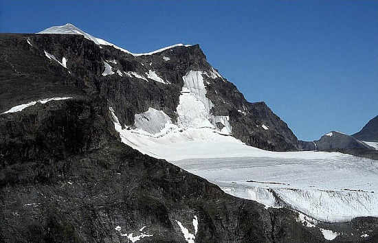
Kebnekaise Photos
View all
photos (2) |
Scandinavia/European Arctic Ranges photos (4) |
photos from mountains in Sweden (7) |
all photos
 Upload new photo
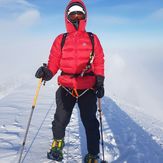
Kebnekaise - Southern Summit
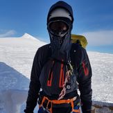
Kebnekaise - Top of Sweden
Kebnekaise
 Like us
 Follow us
