– Lat/Long: 44.17° N 5.28° E
 Mont Ventoux
Weather Forecast, FranceIssued: 1 am Sat 27 Apr Local TimeUpdates in: hr min sUpdate imminent
Mont VentouxWeather Forecast, France
Issued: 1 am Sat 27 Apr Local Time
Updates in:
Update imminent hr min s

Issued: 1 am Sat 27 Apr Local Time
Updates in:
Update imminent hr min s
Days 1–3 Weather SummaryHeavy rain (total 28mm), heaviest during Sun morning. Mild temperatures (max 6°C on Mon night, min 1°C on Sat morning). Mainly gales. | Days 4–6 Weather SummaryHeavy rain (total 27mm), mostly on Tue afternoon. Becoming colder with a light covering of snow, mostly falling on Thu morning. Freeze-thaw conditions (max 5°C on Tue morning, min -1°C on Thu afternoon). Winds decreasing (near gales from the SE on Tue morning, light winds from the SSE by Wed afternoon). | Days 7–9 Weather SummaryA light covering of new snow mostly falling on Sat night. Freeze-thaw conditions (max 4°C on Fri afternoon, min -1°C on Sat night). Mainly gales. | Days 10–12 Weather SummaryA dusting of snow turning to light rain (total 4mm) on Tue night. Freeze-thaw conditions (max 4°C on Wed night, min 0°C on Mon morning). Wind will be generally light. | |||||||||||||||||||||||||||||||||
Saturday 27 | Sunday 28 | Monday 29 | Tuesday 30 | Wednesday 1 | Thursday 2 | Friday 3 | Saturday 4 | Sunday 5 | Monday 6 | Tuesday 7 | Wednesday 8 | |||||||||||||||||||||||||
AM | PM | night | AM | PM | night | AM | PM | night | AM | PM | night | AM | PM | night | AM | PM | night | AM | PM | night | AM | PM | night | AM | PM | night | AM | PM | night | AM | PM | night | AM | PM | night | |
cloudy | cloudy | light rain | heavy rain | mod. rain | light rain | cloudy | light rain | light rain | mod. rain | mod. rain | mod. rain | light rain | light rain | rain shwrs | mod. snow | snow shwrs | clear | clear | some clouds | some clouds | cloudy | light snow | snow shwrs | clear | some clouds | clear | some clouds | risk tstorm | risk tstorm | some clouds | snow shwrs | snow shwrs | clear | risk tstorm | risk tstorm | |
km/h | ||||||||||||||||||||||||||||||||||||
Wave Height Map |  |  |  |  |  |  |  |  |  |  |  |  | ||||||||||||||||||||||||
— | — | — | — | — | — | — | — | — | — | — | — | — | — | — | 7 | 2.0 | — | — | — | — | — | 1.0 | 4 | — | — | — | — | — | — | — | 3 | 1.0 | — | — | — | |
— | — | 3 | 12 | 8 | 0.3 | — | 3 | 2.0 | 7 | 10 | 6 | 1.2 | 3 | 0.6 | — | — | — | — | — | — | — | 0.4 | — | — | — | — | — | 0.2 | 0.1 | — | — | 1.2 | — | 2 | 0.4 | |
max°C | 2 | 4 | 3 | 3 | 5 | 5 | 5 | 5 | 6 | 5 | 4 | 4 | 3 | 3 | 3 | 1 | -1 | 2 | 3 | 4 | 4 | 3 | 2 | 1 | -1 | 1 | 1 | 1 | 2 | 2 | 2 | 2 | 2 | 2 | 3 | 4 |
min°C | 1 | 3 | 3 | 3 | 3 | 5 | 4 | 4 | 5 | 4 | 3 | 3 | 3 | 3 | 2 | 1 | -1 | 0 | 3 | 4 | 4 | 3 | 1 | -1 | -1 | 0 | 0 | 0 | 2 | 2 | 2 | 2 | 2 | 2 | 2 | 3 |
-6 | -5 | -5 | -4 | -5 | -2 | -2 | -3 | -2 | -3 | -4 | -4 | -1 | 0 | -3 | -4 | -5 | -8 | -2 | 1 | 1 | -4 | -7 | -7 | -7 | -5 | -4 | -4 | -1 | -2 | 0 | 0 | 0 | 0 | -1 | -1 | |
2200 | 2450 | 2450 | 2550 | 2550 | 2600 | 2550 | 2600 | 2800 | 2650 | 2550 | 2500 | 2400 | 2400 | 2400 | 2050 | 1650 | 2200 | 2500 | 2650 | 2550 | 2350 | 2100 | 1900 | 1800 | 2050 | 2000 | 2000 | 2250 | 2250 | 2150 | 2150 | 2150 | 2200 | 2350 | 2750 | |
Cloud base (m) | 2600 | 3100 | 1500 | 400 | 650 | 2150 | 2350 | 450 | 2200 | 1700 | 400 | 400 | 400 | 400 | 550 | 350 | 400 | 1500 | 6900 | 2250 | 650 | 5050 | 1900 | 1500 | 1900 | 6650 | 1900 | 6800 | 1750 | 1500 | 3400 | 2150 | 6950 | |||
6:35 | — | — | 6:33 | — | — | 6:31 | — | — | 6:31 | — | — | 6:28 | — | — | 6:28 | — | — | 6:26 | — | — | 6:24 | — | — | 6:24 | — | — | 6:22 | — | — | 6:20 | — | — | 6:20 | — | — | |
— | — | 8:37 | — | — | 8:38 | — | — | 8:39 | — | — | 8:40 | — | — | 8:42 | — | — | 8:44 | — | — | 8:45 | — | — | 8:45 | — | — | 8:46 | — | — | 8:47 | — | — | 8:50 | — | — | 8:51 | |
Mont Ventoux Weather (Days 0-3):
The weather forecast for Mont Ventoux is: Heavy rain (total 28mm), heaviest during Sun morning. Mild temperatures (max 6°C on Mon night, min 1°C on Sat morning). Mainly gales.
Mont Ventoux Weather (Days 3-6):
Heavy rain (total 27mm), mostly on Tue afternoon. Becoming colder with a light covering of snow, mostly falling on Thu morning. Freeze-thaw conditions (max 5°C on Tue morning, min -1°C on Thu afternoon). Winds decreasing (near gales from the SE on Tue morning, light winds from the SSE by Wed afternoon).
Mont Ventoux Weather (Days 6-9):
A light covering of new snow mostly falling on Sat night. Freeze-thaw conditions (max 4°C on Fri afternoon, min -1°C on Sat night). Mainly gales.
This table gives the weather forecast for Mont Ventoux at the specific elevation of 1912 m. Our advanced weather models allow us to provide distinct weather forecasts for several elevations of Mont Ventoux. To see the weather forecasts for the other elevations, use the tab navigation above the table. For a wider overview of the weather, consult the Weather Map of France.
| Weather Station | Temp. | Weather | Wind | Gusts | Cloud / Visibility |
|---|---|---|---|---|---|
Orange | |||||
Orang / aritat Airport | |||||
Caumont Airport | |||||
* NOTE: not all weather observatories update at the same frequency which is the reason why some locations may show data from stations that are further away than known closer ones.
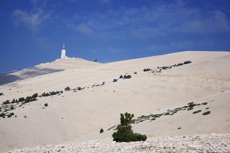
Mont Ventoux Photos
View all
Savoy Alps photos (118) |
Alps photos (1434) |
photos from mountains in France (267) |
all photos
 Upload new photo
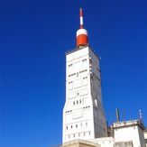
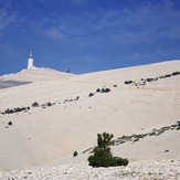

Summit Mont Ventoux
Mont Ventoux
 Like us
 Follow us
