– Lat/Long: 33.98° N 76.02° E
 Nun Kun
Weather Forecast, IndiaIssued: 10 am Fri 26 Apr Local TimeUpdates in: hr min sUpdate imminent
Nun KunWeather Forecast, India
Issued: 10 am Fri 26 Apr Local Time
Updates in:
Update imminent hr min s

Issued: 10 am Fri 26 Apr Local Time
Updates in:
Update imminent hr min s
Days 1–3 Weather SummaryA heavy fall of snow, heaviest during Sun night. Extremely cold (max -23°C on Fri afternoon, min -25°C on Sat morning). Winds increasing (fresh winds from the SW on Fri morning, gales from the SW by Sat afternoon). | Days 4–6 Weather SummaryA heavy fall of snow, heaviest during Mon afternoon. Extremely cold (max -22°C on Mon afternoon, min -30°C on Tue night). Winds decreasing (stormy winds from the S on Mon night, light winds from the ENE by Wed morning). | Days 7–9 Weather SummaryA dusting of new snow. Extremely cold (max -19°C on Fri morning, min -25°C on Thu morning). Winds decreasing (strong winds from the WNW on Thu night, light winds from the SSE by Sat night). | Days 10–12 Weather SummaryA heavy fall of snow, heaviest during Mon afternoon. Extremely cold (max -19°C on Mon afternoon, min -21°C on Sun morning). Winds increasing (light winds from the W on Sun night, strong winds from the WSW by Mon night). | |||||||||||||||||||||||||||||||||
Friday 26 | Saturday 27 | Sunday 28 | Monday 29 | Tuesday 30 | Wednesday 1 | Thursday 2 | Friday 3 | Saturday 4 | Sunday 5 | Monday 6 | Tuesday 7 | |||||||||||||||||||||||||
AM | PM | night | AM | PM | night | AM | PM | night | AM | PM | night | AM | PM | night | AM | PM | night | AM | PM | night | AM | PM | night | AM | PM | night | AM | PM | night | AM | PM | night | AM | PM | night | |
some clouds | some clouds | snow shwrs | snow shwrs | light snow | snow shwrs | light snow | snow shwrs | heavy snow | mod. snow | heavy snow | snow shwrs | clear | light snow | snow shwrs | cloudy | some clouds | some clouds | clear | clear | clear | clear | some clouds | some clouds | some clouds | snow shwrs | snow shwrs | clear | snow shwrs | snow shwrs | clear | mod. snow | snow shwrs | some clouds | snow shwrs | snow shwrs | |
km/h | ||||||||||||||||||||||||||||||||||||
Wave Height Map |  |  |  |  |  |  |  |  |  |  |  |  | ||||||||||||||||||||||||
— | — | 1.0 | 2.0 | 4 | 1.0 | 4 | 2.0 | 11 | 6 | 15 | 11 | — | 1.0 | 5 | — | — | — | — | — | — | — | — | — | — | 1.0 | 2.0 | — | 2.0 | 3 | — | 7 | 4 | — | 4 | 1.0 | |
— | — | — | — | — | — | — | — | — | — | — | — | — | — | — | — | — | — | — | — | — | — | — | — | — | — | — | — | — | — | — | — | — | — | — | — | |
max°C | -24 | -23 | -23 | -24 | -23 | -24 | -24 | -23 | -24 | -24 | -22 | -25 | -25 | -25 | -26 | -28 | -26 | -26 | -25 | -24 | -21 | -19 | -19 | -19 | -20 | -20 | -20 | -20 | -20 | -20 | -20 | -19 | -20 | -21 | -19 | -20 |
min°C | -24 | -24 | -24 | -25 | -24 | -24 | -24 | -24 | -24 | -24 | -24 | -27 | -26 | -26 | -30 | -29 | -27 | -27 | -25 | -24 | -24 | -20 | -20 | -21 | -21 | -21 | -22 | -21 | -20 | -21 | -21 | -19 | -21 | -21 | -20 | -21 |
-38 | -40 | -38 | -41 | -41 | -40 | -42 | -42 | -42 | -43 | -44 | -46 | -44 | -43 | -47 | -40 | -36 | -37 | -37 | -35 | -37 | -33 | -31 | -35 | -34 | -34 | -30 | -27 | -30 | -32 | -33 | -29 | -32 | -34 | -33 | -34 | |
3950 | 3900 | 2750 | 3850 | 3700 | 2700 | 3800 | 3800 | 3550 | 3800 | 3750 | 2850 | 3800 | 3550 | 2350 | 3700 | 3600 | 2750 | 3800 | 3900 | 2500 | 4200 | 4300 | 3750 | 4250 | 4150 | 3350 | 4250 | 4200 | 3200 | 4250 | 4200 | 3200 | 4250 | 4300 | 3300 | |
Cloud base (m) | 6050 | 6900 | 6250 | 5300 | 5100 | 5400 | 4900 | 5000 | 4900 | 4900 | 4950 | 4900 | 5650 | 5050 | 6750 | 6250 | 6350 | 9700 | 5900 | 5850 | 5850 | 5300 | 6300 | 5400 | 5350 | 5050 | 5300 | 5200 | 5900 | 5300 | 4950 | |||||
5:41 | — | — | 5:39 | — | — | 5:39 | — | — | 5:37 | — | — | 5:37 | — | — | 5:35 | — | — | 5:35 | — | — | 5:33 | — | — | 5:33 | — | — | 5:31 | — | — | 5:31 | — | — | 5:30 | — | — | |
— | 7:06 | — | — | 7:07 | — | — | 7:07 | — | — | 7:07 | — | — | 7:08 | — | — | 7:09 | — | — | 7:09 | — | — | 7:10 | — | — | 7:12 | — | — | 7:13 | — | — | 7:14 | — | — | 7:14 | — | |
Nun Kun Weather (Days 0-3):
The weather forecast for Nun Kun is: A heavy fall of snow, heaviest during Sun night. Extremely cold (max -23°C on Fri afternoon, min -25°C on Sat morning). Winds increasing (fresh winds from the SW on Fri morning, gales from the SW by Sat afternoon).
Nun Kun Weather (Days 3-6):
A heavy fall of snow, heaviest during Mon afternoon. Extremely cold (max -22°C on Mon afternoon, min -30°C on Tue night). Winds decreasing (stormy winds from the S on Mon night, light winds from the ENE by Wed morning).
Nun Kun Weather (Days 6-9):
A dusting of new snow. Extremely cold (max -19°C on Fri morning, min -25°C on Thu morning). Winds decreasing (strong winds from the WNW on Thu night, light winds from the SSE by Sat night).
This table gives the weather forecast for Nun Kun at the specific elevation of 7135 m. Our advanced weather models allow us to provide distinct weather forecasts for several elevations of Nun Kun. To see the weather forecasts for the other elevations, use the tab navigation above the table. For a wider overview of the weather, consult the Weather Map of India.
Nun Kun Photos
View all
Punjab Himalaya photos (13) |
Greater Himalaya photos (191) |
photos from mountains in India (72) |
all photos
 Upload new photo
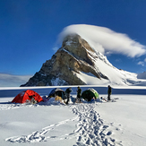
 See 13 more Nun Kun photos
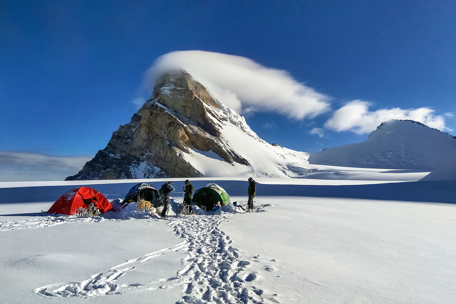
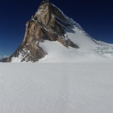
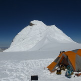
Camp 2 Mt. Kun (7077mt)
Nun-Kun massif
Camp 3 (Mt. Kun 7077mt)
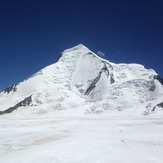
Mt Nun from Nun Kun icefield
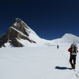
Approaching Kun from Camp 2
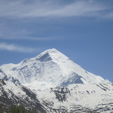
Mt Nun(7135m).
Nun north face
 Like us
 Follow us
