– Lat/Long: 45.87° N 6.99° E
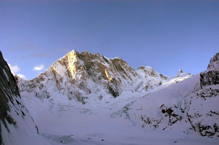
 Pointe Walker
Weather Forecast, FranceIssued: 6 pm Thu 31 Oct Local TimeUpdates in: hr min sUpdate imminent
Pointe WalkerWeather Forecast, France
Issued: 6 pm Thu 31 Oct Local Time
Updates in:
Update imminent hr min s

Issued: 6 pm Thu 31 Oct Local Time
Updates in:
Update imminent hr min s
Days 1–4 Weather SummaryMostly dry. Temperatures will be below freezing (max -1°C on Fri morning, min -3°C on Thu afternoon). Wind will be generally light. | Days 5–7 Weather SummaryMostly dry. Temperatures will be below freezing (max -2°C on Sun afternoon, min -8°C on Tue night). Wind will be generally light. | ||||||||||||||||
Thu 31 | Friday 1 | Saturday 2 | Sunday 3 | Monday 4 | Tuesday 5 | ||||||||||||
PM | night | AM | PM | night | AM | PM | night | AM | PM | night | AM | PM | night | AM | PM | night | |
clear | clear | clear | clear | clear | clear | clear | clear | clear | clear | clear | clear | clear | clear | clear | clear | clear | |
km/h | |||||||||||||||||
 |  |  |  |  |  | ||||||||||||
— | — | — | — | — | — | — | — | — | — | — | — | — | — | — | — | — | |
— | — | — | — | — | — | — | — | — | — | — | — | — | — | — | — | — | |
max°C | -2 | -2 | -1 | -2 | -2 | -1 | -1 | -1 | -2 | -2 | -2 | -2 | -3 | -4 | -6 | -7 | -7 |
min°C | -3 | -2 | -2 | -3 | -2 | -1 | -1 | -2 | -2 | -2 | -2 | -2 | -4 | -6 | -7 | -7 | -8 |
-9 | -7 | -7 | -8 | -6 | -5 | -5 | -4 | -2 | -2 | -4 | -6 | -9 | -12 | -11 | -10 | -11 | |
3750 | 3850 | 4000 | 3850 | 3900 | 4050 | 4050 | 4050 | 3950 | 3900 | 3900 | 3900 | 3750 | 3550 | 3200 | 3100 | 3000 | |
Cloud base (m) | 9650 | 9750 | 9150 | 9800 | 9650 | 9300 | |||||||||||
— | — | 7:13 | — | — | 7:13 | — | — | 7:16 | — | — | 7:16 | — | — | 7:18 | — | — | |
5:17 | — | — | 5:16 | — | — | 5:15 | — | — | 5:14 | — | — | 5:12 | — | — | 5:10 | — | |
Pointe Walker Weather (Days 0-3):
The weather forecast for Pointe Walker is: Mostly dry. Temperatures will be below freezing (max -1°C on Fri morning, min -3°C on Thu afternoon). Wind will be generally light.
Pointe Walker Weather (Days 3-6):
Mostly dry. Temperatures will be below freezing (max -2°C on Sun afternoon, min -8°C on Tue night). Wind will be generally light.
This table gives the weather forecast for Pointe Walker at the specific elevation of 4208 m. Our advanced weather models allow us to provide distinct weather forecasts for several elevations of Pointe Walker. To see the weather forecasts for the other elevations, use the tab navigation above the table. For a wider overview of the weather, consult the Weather Map of France.
Pointe Walker Photos
View all
Savoy Alps photos (122) |
Alps photos (1448) |
photos from mountains in France (276) |
all photos
 Upload new photo
Pointe Walker

