– Lat/Long: 40.80° N 110.82° W
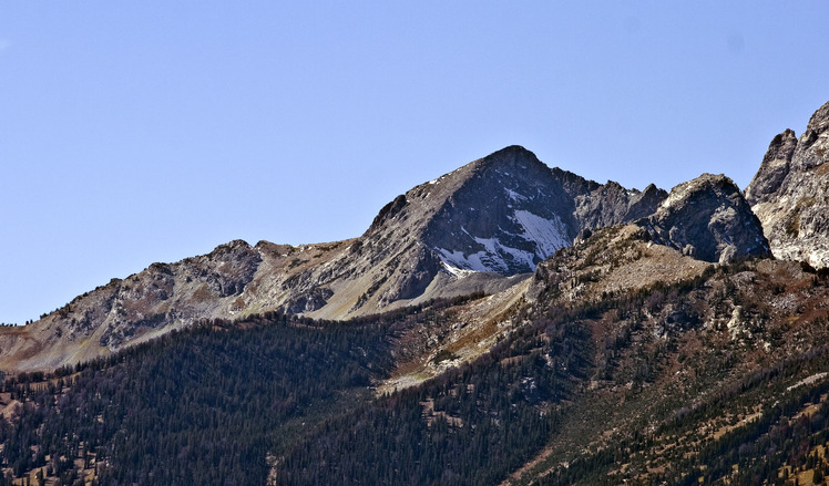
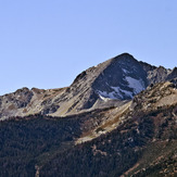
 Static Peak
Weather Forecast, United StatesIssued: 11 pm Wed 08 May Local TimeUpdates in: hr min sUpdate imminent
Static PeakWeather Forecast, United States
Issued: 11 pm Wed 08 May Local Time
Updates in:
Update imminent hr min s

Issued: 11 pm Wed 08 May Local Time
Updates in:
Update imminent hr min s
Days 1–4 Weather SummaryA light covering of new snow mostly falling on Thu morning. Freeze-thaw conditions (max 1°C on Sat afternoon, min -11°C on Wed night). Winds decreasing (fresh winds from the ENE on Thu morning, light winds from the ENE by Fri night). | Days 5–7 Weather SummaryA dusting of snow turning to light rain (total 3mm) on Mon afternoon. Freeze-thaw conditions (max 4°C on Sun afternoon, min -2°C on Sat night). Winds increasing (light winds from the NNW on Sat night, fresh winds from the WNW by Tue afternoon). | Days 8–10 Weather SummaryLight rain (total 3mm), mostly falling on Thu night. Freeze-thaw conditions (max 8°C on Thu afternoon, min 0°C on Tue night). Winds increasing (light winds from the W on Tue night, strong winds from the SW by Thu afternoon). | Days 11–13 Weather SummaryLight rain (total 5mm), mostly falling on Sun afternoon. Freeze-thaw conditions (max 9°C on Sat afternoon, min -1°C on Sun night). Winds decreasing (strong winds from the WNW on Sun afternoon, calm by Mon morning). | |||||||||||||||||||||||||||||||||
Thursday 9 | Friday 10 | Saturday 11 | Sunday 12 | Monday 13 | Tuesday 14 | Wednesday 15 | Thursday 16 | Friday 17 | Saturday 18 | Sunday 19 | Mon 20 | |||||||||||||||||||||||||
night | AM | PM | night | AM | PM | night | AM | PM | night | AM | PM | night | AM | PM | night | AM | PM | night | AM | PM | night | AM | PM | night | AM | PM | night | AM | PM | night | AM | PM | night | AM | PM | |
some clouds | snow shwrs | snow shwrs | some clouds | light snow | snow shwrs | some clouds | clear | some clouds | snow shwrs | clear | risk tstorm | clear | rain shwrs | risk tstorm | clear | clear | clear | clear | clear | clear | clear | rain shwrs | risk tstorm | rain shwrs | clear | clear | clear | clear | some clouds | some clouds | rain shwrs | risk tstorm | clear | clear | clear | |
km/h | ||||||||||||||||||||||||||||||||||||
Wave Height Map |  |  |  |  | 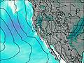 | 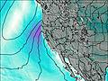 | 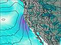 | 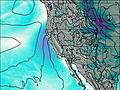 |  |  |  |  |  | |||||||||||||||||||||||
— | 3 | 1.0 | — | 1.0 | 2.0 | — | — | — | 1.0 | — | — | — | — | — | — | — | — | — | — | — | — | — | — | — | — | — | — | — | — | — | — | — | — | — | — | |
— | — | — | — | — | — | — | — | — | — | — | 0.3 | — | 0.7 | 2.0 | — | — | — | — | — | — | — | 0.1 | 0.9 | 1.6 | — | — | — | — | — | — | 1.6 | 4 | — | — | — | |
max°C | -9 | -6 | -5 | -7 | -3 | -2 | -5 | 0 | 1 | -1 | 2 | 4 | 0 | 4 | 4 | 0 | 3 | 3 | 0 | 5 | 5 | 3 | 6 | 8 | 3 | 7 | 8 | 5 | 8 | 9 | 6 | 4 | 2 | 0 | 7 | 8 |
min°C | -11 | -7 | -5 | -9 | -6 | -3 | -6 | -2 | 1 | -2 | 1 | 3 | 0 | 3 | 3 | -1 | 1 | 2 | 0 | 3 | 5 | 3 | 6 | 6 | 2 | 5 | 8 | 3 | 6 | 8 | 2 | 4 | 2 | -1 | 3 | 8 |
-16 | -13 | -13 | -16 | -12 | -6 | -9 | -5 | -3 | -5 | -2 | -1 | -3 | -2 | -2 | -6 | -3 | -3 | -4 | -1 | 0 | 0 | 2 | 1 | -3 | 1 | 4 | 0 | 3 | 4 | 0 | 0 | -4 | -5 | 3 | 6 | |
1550 | 2450 | 2700 | 2300 | 2650 | 3100 | 2500 | 3200 | 3600 | 3300 | 3500 | 3950 | 3450 | 3800 | 3900 | 3450 | 3550 | 3850 | 3500 | 3800 | 4150 | 3850 | 4200 | 4450 | 3850 | 4150 | 4450 | 4100 | 4200 | 4550 | 4250 | 4000 | 3800 | 3150 | 3950 | 4500 | |
Cloud base (m) | 3100 | 3100 | 3250 | 3150 | 3100 | 3250 | 3700 | 3100 | 4150 | 4000 | 9100 | 9300 | 4950 | 4350 | 4550 | 4600 | 4650 | 5150 | 5700 | 6850 | 6350 | 3350 | 3650 | |||||||||||||
— | 6:11 | — | — | 6:09 | — | — | 6:09 | — | — | 6:07 | — | — | 6:07 | — | — | 6:05 | — | — | 6:05 | — | — | 6:03 | — | — | 6:03 | — | — | 6:01 | — | — | 6:01 | — | — | 6:01 | — | |
— | — | 8:28 | — | — | 8:29 | — | — | 8:30 | — | — | 8:30 | — | — | 8:31 | — | — | 8:32 | — | — | 8:34 | — | — | 8:35 | — | — | 8:36 | — | — | 8:37 | — | — | 8:37 | — | — | 8:38 | |
Static Peak Weather (Days 0-3):
The weather forecast for Static Peak is: A light covering of new snow mostly falling on Thu morning. Freeze-thaw conditions (max 1°C on Sat afternoon, min -11°C on Wed night). Winds decreasing (fresh winds from the ENE on Thu morning, light winds from the ENE by Fri night).
Static Peak Weather (Days 3-6):
A dusting of snow turning to light rain (total 3mm) on Mon afternoon. Freeze-thaw conditions (max 4°C on Sun afternoon, min -2°C on Sat night). Winds increasing (light winds from the NNW on Sat night, fresh winds from the WNW by Tue afternoon).
Static Peak Weather (Days 6-9):
Light rain (total 3mm), mostly falling on Thu night. Freeze-thaw conditions (max 8°C on Thu afternoon, min 0°C on Tue night). Winds increasing (light winds from the W on Tue night, strong winds from the SW by Thu afternoon).
This table gives the weather forecast for Static Peak at the specific elevation of 3445 m. Our advanced weather models allow us to provide distinct weather forecasts for several elevations of Static Peak. To see the weather forecasts for the other elevations, use the tab navigation above the table. For a wider overview of the weather, consult the Weather Map of Utah.
 Like us
 Follow us
