
– Lat/Long: 39.43° N 106.11° W
 Crystal Peak (Tenmile Range)
Weather Forecast, United StatesIssued: 5 am Wed 12 Jun Local TimeUpdates in: hr min sUpdate imminent
Crystal Peak (Tenmile Range)Weather Forecast, United States
Issued: 5 am Wed 12 Jun Local Time
Updates in:
Update imminent hr min s

Issued: 5 am Wed 12 Jun Local Time
Updates in:
Update imminent hr min s
Days 1–3 Weather SummaryLight rain (total 4mm) at first, then becoming colder with a dusting of snow on Fri night. Freeze-thaw conditions (max 10°C on Thu morning, min 0°C on Fri night). Winds decreasing (fresh winds from the WNW on Wed morning, light winds from the NW by Fri night). | Days 4–6 Weather SummarySome drizzle, heaviest during Sat afternoon. Freeze-thaw conditions (max 10°C on Sun afternoon, min 0°C on Mon night). Winds increasing (light winds from the W on Sat morning, strong winds from the WSW by Mon afternoon). | |||||||||||||||||
Wednesday 12 | Thursday 13 | Friday 14 | Saturday 15 | Sunday 16 | Monday 17 | |||||||||||||
AM | PM | night | AM | PM | night | AM | PM | night | AM | PM | night | AM | PM | night | AM | PM | night | |
some clouds | rain shwrs | clear | clear | some clouds | rain shwrs | light rain | rain shwrs | snow shwrs | some clouds | rain shwrs | clear | clear | clear | clear | clear | clear | clear | |
km/h | ||||||||||||||||||
Wave Height Map | 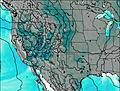 | 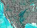 | 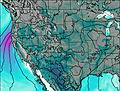 | 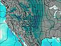 | 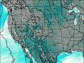 | 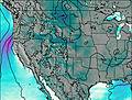 | ||||||||||||
— | — | — | — | — | — | — | — | 2.0 | — | — | — | — | — | — | — | — | — | |
— | 0.1 | — | — | — | 0.1 | 0.2 | 4 | — | — | 1.6 | — | — | — | — | — | — | — | |
max°C | 9 | 9 | 5 | 10 | 10 | 6 | 6 | 4 | 2 | 7 | 8 | 4 | 9 | 10 | 5 | 9 | 10 | 5 |
min°C | 7 | 7 | 3 | 8 | 9 | 1 | 6 | 4 | 0 | 4 | 4 | 2 | 8 | 9 | 1 | 6 | 9 | 0 |
3 | 4 | 0 | 5 | 7 | -5 | 2 | 0 | -2 | 1 | -1 | -2 | 4 | 5 | -4 | 2 | 4 | -6 | |
5100 | 5300 | 4750 | 5150 | 5350 | 4650 | 4950 | 4800 | 4300 | 4800 | 4850 | 4700 | 5250 | 5300 | 4650 | 5100 | 5450 | 4750 | |
Cloud base (m) | 5450 | 6550 | 5650 | 5750 | 3300 | 4400 | 9400 | 6550 | 6300 | |||||||||
5:35 | — | — | 5:35 | — | — | 5:35 | — | — | 5:35 | — | — | 5:37 | — | — | 5:37 | — | — | |
— | 8:31 | — | — | 8:31 | — | — | 8:32 | — | — | 8:32 | — | — | 8:32 | — | — | 8:34 | — | |
Crystal Peak (Tenmile Range) Weather (Days 0-3):
The weather forecast for Crystal Peak (Tenmile Range) is: Light rain (total 4mm) at first, then becoming colder with a dusting of snow on Fri night. Freeze-thaw conditions (max 10°C on Thu morning, min 0°C on Fri night). Winds decreasing (fresh winds from the WNW on Wed morning, light winds from the NW by Fri night).
Crystal Peak (Tenmile Range) Weather (Days 3-6):
Some drizzle, heaviest during Sat afternoon. Freeze-thaw conditions (max 10°C on Sun afternoon, min 0°C on Mon night). Winds increasing (light winds from the W on Sat morning, strong winds from the WSW by Mon afternoon).
This table gives the weather forecast for Crystal Peak (Tenmile Range) at the specific elevation of 4222 m. Our advanced weather models allow us to provide distinct weather forecasts for several elevations of Crystal Peak (Tenmile Range). To see the weather forecasts for the other elevations, use the tab navigation above the table. For a wider overview of the weather, consult the Weather Map of Colorado.
| Weather Station | Temp. | Weather | Wind | Gusts | Cloud / Visibility |
|---|---|---|---|---|---|
Red Cliff Pass Airport | |||||
Leadville Airport |
* NOTE: not all weather observatories update at the same frequency which is the reason why some locations may show data from stations that are further away than known closer ones.
 Like us
 Follow us
