– Lat/Long: 57.72° N 5.35° W
 A'Mhaighdean
Weather Forecast, United KingdomIssued: 6 am Tue 22 Apr Local TimeUpdates in: hr min sUpdate imminent
A'Mhaighdean Weather Forecast, United Kingdom
Issued: 6 am Tue 22 Apr Local Time
Updates in:
Update imminent hr min s

Issued: 6 am Tue 22 Apr Local Time
Updates in:
Update imminent hr min s
Days 1–3 Weather SummarySome drizzle, heaviest during Wed afternoon. Mild temperatures (max 6°C on Wed afternoon, min 2°C on Tue morning). Wind will be generally light. | Days 4–6 Weather SummaryModerate rain (total 18mm), heaviest on Sun night. Mild temperatures (max 6°C on Sun morning, min 2°C on Sun night). Winds increasing (light winds from the SSW on Fri night, near gales from the SSW by Sun afternoon). | |||||||||||||||||
Tuesday 22 | Wednesday 23 | Thursday 24 | Friday 25 | Saturday 26 | Sunday 27 | |||||||||||||
AM | PM | night | AM | PM | night | AM | PM | night | AM | PM | night | AM | PM | night | AM | PM | night | |
some clouds | light rain | some clouds | light rain | rain shwrs | some clouds | clear | rain shwrs | rain shwrs | light rain | light rain | light rain | rain shwrs | cloudy | light rain | light rain | light rain | rain shwrs | |
km/h | ||||||||||||||||||
 |  |  |  |  |  | |||||||||||||
— | — | — | — | — | — | — | — | — | — | — | — | — | — | — | — | — | — | |
— | 0.2 | — | 0.1 | 0.5 | — | — | 0.1 | 0.1 | 0.2 | 0.5 | 0.7 | 1.2 | — | 0.2 | 2.0 | 2 | 11 | |
max°C | 3 | 5 | 4 | 5 | 6 | 4 | 6 | 6 | 5 | 5 | 5 | 4 | 5 | 5 | 5 | 6 | 6 | 3 |
min°C | 2 | 4 | 3 | 4 | 6 | 3 | 5 | 6 | 4 | 5 | 5 | 4 | 4 | 5 | 4 | 5 | 6 | 2 |
-1 | 1 | 0 | 1 | 4 | 3 | 2 | 3 | 0 | 0 | 0 | -1 | -1 | 0 | -1 | -1 | 0 | -5 | |
1200 | 1550 | 1700 | 1500 | 1600 | 1700 | 1650 | 1700 | 1850 | 2000 | 1850 | 1750 | 1550 | 1550 | 1700 | 2050 | 2150 | 1300 | |
Cloud base (m) | 750 | 1450 | 900 | 750 | 950 | 2250 | 900 | 900 | 1700 | 550 | 250 | 350 | 250 | 850 | 700 | 250 | 250 | 300 |
5:54 | — | — | 5:50 | — | — | 5:48 | — | — | 5:46 | — | — | 5:43 | — | — | 5:41 | — | — | |
— | 8:46 | — | — | 8:49 | — | — | 8:51 | — | — | 8:52 | — | — | 8:54 | — | — | 8:58 | — | |
Loading...
A'Mhaighdean Weather (Days 0-3):
The weather forecast for A'Mhaighdean is: Some drizzle, heaviest during Wed afternoon. Mild temperatures (max 6°C on Wed afternoon, min 2°C on Tue morning). Wind will be generally light.
A'Mhaighdean Weather (Days 3-6):
Moderate rain (total 18mm), heaviest on Sun night. Mild temperatures (max 6°C on Sun morning, min 2°C on Sun night). Winds increasing (light winds from the SSW on Fri night, near gales from the SSW by Sun afternoon).
This table gives the weather forecast for A'Mhaighdean at the specific elevation of 967 m. Our advanced weather models allow us to provide distinct weather forecasts for several elevations of A'Mhaighdean. To see the weather forecasts for the other elevations, use the tab navigation above the table. For a wider overview of the weather, consult the Weather Map of United Kingdom.
| Weather Station | Temp. | Weather | Wind | Gusts | Cloud / Visibility |
|---|---|---|---|---|---|
AultbeaNO2 | |||||
BealachNABA NO 2 | |||||
SHIP4935 | |||||
SHIP5716 | |||||
SHIP2676 | |||||
SHIP9153 | |||||
SHIP2436 | |||||
SHIP7916 |
* NOTE: not all weather observatories update at the same frequency which is the reason why some locations may show data from stations that are further away than known closer ones.
A'Mhaighdean Photos
View all
Northwest Highlands photos (38) |
Scottish Highlands photos (288) |
photos from mountains in United Kingdom (1953) |
all photos
 Upload new photo
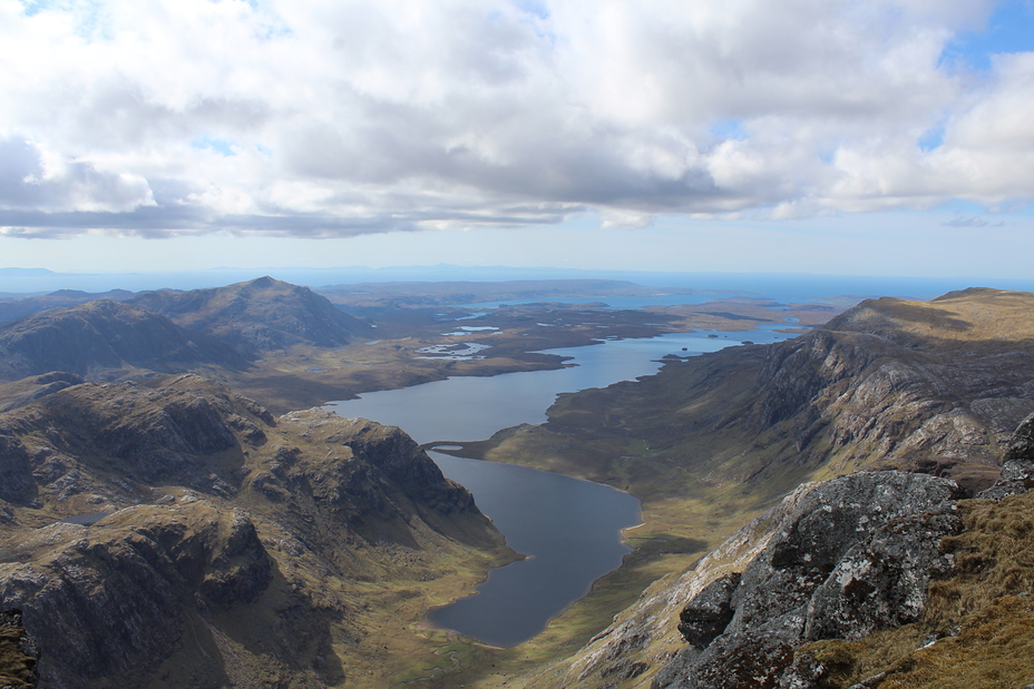
Dubh Loch with Fionn Loch and the sea beyond from A' Mhaighdean summit

