– Lat/Long: 62.67° S 60.21° W
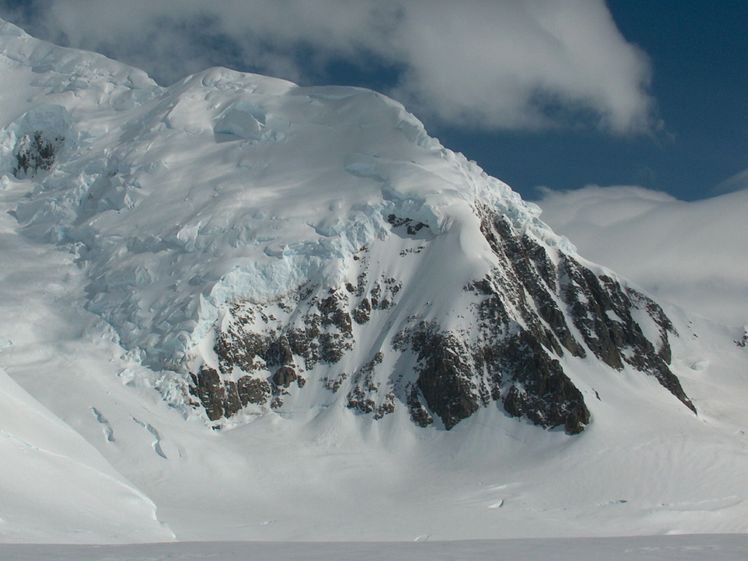
 Academia Peak
Weather Forecast, AntarcticaIssued: 2 am Tue 01 Apr Local TimeUpdates in: hr min sUpdate imminent
Academia Peak Weather Forecast, Antarctica
Issued: 2 am Tue 01 Apr Local Time
Updates in:
Update imminent hr min s

Issued: 2 am Tue 01 Apr Local Time
Updates in:
Update imminent hr min s
Days 1–3 Weather SummaryA dusting of new snow. Temperatures will be below freezing (max 0°C on Thu morning, min -10°C on Tue night). Winds increasing (calm on Tue night, gales from the WSW by Thu night). | Days 4–6 Weather SummaryLight rain (total 6mm) at first, then becoming colder with a dusting of snow on Sun night. Freeze-thaw conditions (max 3°C on Sun afternoon, min -1°C on Sun night). Winds increasing (moderate winds from the WNW on Sat morning, near gales from the WNW by Sun afternoon). | Days 7–9 Weather SummaryMild with light rain (total 8mm) on Tue afternoon Becoming colder with a light covering of snow, mostly falling on Wed night. Freeze-thaw conditions (max 2°C on Tue morning, min -2°C on Tue night). Winds increasing (moderate winds from the WNW on Mon night, extremely windy from the W by Tue night). | Days 10–12 Weather SummaryA dusting of new snow. Freeze-thaw conditions (max 1°C on Thu morning, min -7°C on Fri night). Winds decreasing (strong winds from the E on Fri afternoon, light winds from the SW by Sun morning). | |||||||||||||||||||||||||||||||||
Tuesday 1 | Wednesday 2 | Thursday 3 | Friday 4 | Saturday 5 | Sunday 6 | Monday 7 | Tuesday 8 | Wednesday 9 | Thursday 10 | Friday 11 | Saturday 12 | |||||||||||||||||||||||||
AM | PM | night | AM | PM | night | AM | PM | night | AM | PM | night | AM | PM | night | AM | PM | night | AM | PM | night | AM | PM | night | AM | PM | night | AM | PM | night | AM | PM | night | AM | PM | night | |
snow shwrs | some clouds | some clouds | cloudy | some clouds | clear | cloudy | cloudy | cloudy | some clouds | cloudy | cloudy | cloudy | cloudy | light rain | cloudy | mod. rain | light snow | cloudy | cloudy | some clouds | light snow | light snow | some clouds | cloudy | light snow | light snow | light snow | cloudy | some clouds | some clouds | cloudy | clear | some clouds | some clouds | some clouds | |
km/h | ||||||||||||||||||||||||||||||||||||
 |  |  |  |  |  |  |  |  |  |  |  | |||||||||||||||||||||||||
1.0 | — | — | — | — | — | — | — | — | — | — | — | — | — | — | — | — | 1.0 | — | — | — | 1.0 | 1.0 | — | — | 1.0 | 3 | 1.0 | — | — | — | — | — | — | — | — | |
— | — | — | — | — | — | — | — | — | — | — | — | — | — | 0.1 | — | 6 | — | — | — | — | — | 8 | — | — | — | — | — | — | — | — | — | — | — | — | — | |
max°C | -7 | -7 | -8 | -7 | -3 | -1 | 0 | 0 | 0 | 0 | 0 | 1 | 1 | 2 | 2 | 2 | 3 | 1 | 0 | -1 | 0 | 2 | 2 | -1 | 1 | 1 | 1 | 1 | 0 | 0 | -3 | -5 | -6 | -4 | -2 | -1 |
min°C | -8 | -7 | -10 | -9 | -5 | -2 | 0 | 0 | -1 | 0 | 0 | 0 | 0 | 2 | 2 | 2 | 2 | -1 | 0 | -1 | -1 | 1 | 0 | -2 | 0 | 1 | 0 | 1 | 0 | -2 | -3 | -6 | -7 | -6 | -3 | -2 |
-14 | -11 | -16 | -17 | -14 | -9 | -6 | -8 | -10 | -8 | -8 | -8 | -6 | -4 | -4 | -4 | -6 | -9 | -7 | -9 | -8 | -5 | -10 | -14 | -9 | -9 | -8 | -6 | -6 | -8 | -7 | -16 | -13 | -12 | -9 | -6 | |
0 | 0 | 0 | 0 | 0 | 0 | 0 | 0 | 350 | 700 | 550 | 600 | 600 | 1700 | 1800 | 1450 | 1850 | 500 | 450 | 400 | 400 | 1000 | 1300 | 250 | 450 | 850 | 450 | 800 | 650 | 100 | 0 | 0 | 0 | 0 | 0 | 0 | |
Cloud base (m) | 250 | 200 | 50 | 50 | 100 | 100 | 50 | 50 | 100 | 50 | 50 | 150 | 50 | 0 | 50 | 50 | 50 | 50 | 0 | 100 | 50 | 650 | 200 | 50 | 350 | 150 | 0 | 0 | 0 | 1650 | 200 | 200 | 50 | 100 | ||
7:33 | — | — | 7:35 | — | — | 7:37 | — | — | 7:41 | — | — | 7:43 | — | — | 7:47 | — | — | 7:48 | — | — | 7:52 | — | — | 7:54 | — | — | 7:56 | — | — | 8:00 | — | — | 8:03 | — | — | |
— | 6:34 | — | — | 6:30 | — | — | 6:28 | — | — | 6:23 | — | — | 6:21 | — | — | 6:17 | — | — | 6:14 | — | — | 6:10 | — | — | 6:07 | — | — | 6:05 | — | — | 6:00 | — | — | 5:58 | — | |
Academia Peak Weather (Days 0-3):
The weather forecast for Academia Peak is: A dusting of new snow. Temperatures will be below freezing (max 0°C on Thu morning, min -10°C on Tue night). Winds increasing (calm on Tue night, gales from the WSW by Thu night).
Academia Peak Weather (Days 3-6):
Light rain (total 6mm) at first, then becoming colder with a dusting of snow on Sun night. Freeze-thaw conditions (max 3°C on Sun afternoon, min -1°C on Sun night). Winds increasing (moderate winds from the WNW on Sat morning, near gales from the WNW by Sun afternoon).
Academia Peak Weather (Days 6-9):
Mild with light rain (total 8mm) on Tue afternoon Becoming colder with a light covering of snow, mostly falling on Wed night. Freeze-thaw conditions (max 2°C on Tue morning, min -2°C on Tue night). Winds increasing (moderate winds from the WNW on Mon night, extremely windy from the W by Tue night).
This table gives the weather forecast for Academia Peak at the specific elevation of 500 m. Our advanced weather models allow us to provide distinct weather forecasts for several elevations of Academia Peak. To see the weather forecasts for the other elevations, use the tab navigation above the table. For a wider overview of the weather, consult the Weather Map of Antarctica.
| Weather Station | Temp. | Weather | Wind | Gusts | Cloud / Visibility |
|---|---|---|---|---|---|
Captain Arturo Prat Base | |||||
CentroMet.Antártico Presidente Eduardo Frei | |||||
Teniente R. Marsh Airport | |||||
Dinamet | |||||
BaseCarlini | |||||
BaseEsperanza | |||||
BaseMarambio | |||||
BaseSanMartin | |||||
BaseOrcadas | |||||
* NOTE: not all weather observatories update at the same frequency which is the reason why some locations may show data from stations that are further away than known closer ones.
Academia Peak Photos
View all
Antarctica Ranges photos (2) |
photos from mountains in Antarctica (37) |
all photos
 Upload new photo
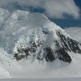
Academia Peak

