– Lat/Long: 62.64° S 60.13° W
 Aheloy Nunatak
Weather Forecast, AntarcticaIssued: 2 am Wed 23 Apr Local TimeUpdates in: hr min sUpdate imminent
Aheloy Nunatak Weather Forecast, Antarctica
Issued: 2 am Wed 23 Apr Local Time
Updates in:
Update imminent hr min s

Issued: 2 am Wed 23 Apr Local Time
Updates in:
Update imminent hr min s
Days 1–3 Weather SummaryA light covering of new snow mostly falling on Fri night. Freeze-thaw conditions (max 2°C on Thu night, min -1°C on Wed morning). Winds increasing (calm on Wed night, strong winds from the N by Fri morning). | Days 4–6 Weather SummaryA heavy fall of snow, heaviest during Sun night. Freeze-thaw conditions (max 1°C on Sat morning, min -4°C on Mon afternoon). Winds increasing (calm on Sat afternoon, gales from the NE by Sun night). | |||||||||||||||||
Wednesday 23 | Thursday 24 | Friday 25 | Saturday 26 | Sunday 27 | Monday 28 | |||||||||||||
AM | PM | night | AM | PM | night | AM | PM | night | AM | PM | night | AM | PM | night | AM | PM | night | |
clear | cloudy | cloudy | some clouds | cloudy | cloudy | light rain | light snow | mod. snow | light snow | cloudy | light snow | some clouds | light snow | mod. snow | snow shwrs | some clouds | light snow | |
km/h | ||||||||||||||||||
 |  |  |  |  |  | |||||||||||||
— | — | — | — | — | — | — | 1.0 | 8 | 1.0 | — | 5 | — | 2.0 | 7 | 1.0 | — | 4 | |
— | — | — | — | — | — | 0.8 | — | — | — | — | — | — | — | — | — | — | — | |
max°C | -1 | -1 | -1 | -1 | 0 | 2 | 2 | 2 | 1 | 1 | 1 | 0 | -3 | -2 | -1 | -3 | -3 | 1 |
min°C | -1 | -1 | -1 | -1 | -1 | 1 | 2 | 1 | 1 | 0 | 1 | -3 | -3 | -2 | -2 | -3 | -4 | -2 |
-4 | -4 | -3 | -4 | -7 | -5 | -4 | -6 | -6 | -6 | -4 | -11 | -10 | -9 | -12 | -8 | -9 | -9 | |
0 | 200 | 200 | 0 | 50 | 1600 | 1200 | 1200 | 950 | 450 | 900 | 100 | 0 | 50 | 100 | 0 | 0 | 600 | |
Cloud base (m) | 100 | 100 | 50 | 50 | 550 | 0 | 50 | 50 | 200 | 0 | ||||||||
8:33 | — | — | 8:34 | — | — | 8:37 | — | — | 8:41 | — | — | 8:44 | — | — | 8:45 | — | — | |
— | 5:22 | — | — | 5:20 | — | — | 5:16 | — | — | 5:14 | — | — | 5:10 | — | — | 5:07 | — | |
Loading...
Aheloy Nunatak Weather (Days 0-3):
The weather forecast for Aheloy Nunatak is: A light covering of new snow mostly falling on Fri night. Freeze-thaw conditions (max 2°C on Thu night, min -1°C on Wed morning). Winds increasing (calm on Wed night, strong winds from the N by Fri morning).
Aheloy Nunatak Weather (Days 3-6):
A heavy fall of snow, heaviest during Sun night. Freeze-thaw conditions (max 1°C on Sat morning, min -4°C on Mon afternoon). Winds increasing (calm on Sat afternoon, gales from the NE by Sun night).
This table gives the weather forecast for Aheloy Nunatak at the specific elevation of 390 m. Our advanced weather models allow us to provide distinct weather forecasts for several elevations of Aheloy Nunatak. To see the weather forecasts for the other elevations, use the tab navigation above the table. For a wider overview of the weather, consult the Weather Map of Antarctica.
| Weather Station | Temp. | Weather | Wind | Gusts | Cloud / Visibility |
|---|---|---|---|---|---|
Captain Arturo Prat Base | |||||
Centro Met. Antártico Presidente Eduardo Frei | |||||
Teniente R. Marsh Airport | |||||
Dinamet | |||||
King Sejong | |||||
ASCATB287E68S | |||||
ASCATB288E69S | |||||
ASCATB287E69S | |||||
ASCATB286E68S | |||||
ASCATB285E68S |
* NOTE: not all weather observatories update at the same frequency which is the reason why some locations may show data from stations that are further away than known closer ones.
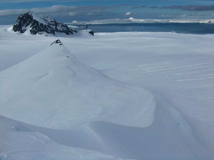
Aheloy Nunatak Photos
View all
Antarctica Ranges photos (2) |
photos from mountains in Antarctica (37) |
all photos
 Upload new photo
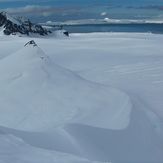
Aheloy Nunatak

