
– Lat/Long: 46.06° N 7.87° E
 Alphubel
Weather Forecast, SwitzerlandIssued: 1 pm Sun 30 Mar Local TimeUpdates in: hr min sUpdate imminent
Alphubel Weather Forecast, Switzerland
Issued: 1 pm Sun 30 Mar Local Time
Updates in:
Update imminent hr min s

Issued: 1 pm Sun 30 Mar Local Time
Updates in:
Update imminent hr min s
Days 1–4 Weather SummaryA light covering of new snow mostly falling on Tue afternoon. Temperatures will be well below freezing (max -6°C on Sun afternoon, min -15°C on Tue afternoon). Winds decreasing (fresh winds from the NNW on Sun night, light winds from the NE by Tue morning). | Days 5–7 Weather SummaryA dusting of new snow. Temperatures will be below freezing (max -5°C on Fri afternoon, min -11°C on Wed night). Wind will be generally light. | ||||||||||||||||
Sun 30 | Monday 31 | Tuesday 1 | Wednesday 2 | Thursday 3 | Friday 4 | ||||||||||||
PM | night | AM | PM | night | AM | PM | night | AM | PM | night | AM | PM | night | AM | PM | night | |
clear | clear | clear | clear | clear | some clouds | snow shwrs | light snow | snow shwrs | snow shwrs | some clouds | clear | some clouds | some clouds | some clouds | some clouds | cloudy | |
km/h | |||||||||||||||||
 |  |  |  | 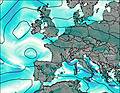 |  | ||||||||||||
— | — | — | — | — | — | 4 | 3 | 2.0 | 2.0 | — | — | — | — | — | — | — | |
— | — | — | — | — | — | — | — | — | — | — | — | — | — | — | — | — | |
max°C | -6 | -6 | -8 | -8 | -7 | -10 | -14 | -12 | -11 | -10 | -10 | -8 | -7 | -7 | -6 | -5 | -5 |
min°C | -6 | -8 | -8 | -8 | -7 | -13 | -15 | -13 | -11 | -10 | -11 | -9 | -8 | -7 | -7 | -5 | -6 |
-12 | -18 | -17 | -17 | -15 | -20 | -23 | -22 | -18 | -17 | -17 | -12 | -11 | -11 | -10 | -9 | -6 | |
2600 | 1800 | 2250 | 2300 | 2250 | 1650 | 1700 | 1750 | 2000 | 2150 | 1800 | 2300 | 2450 | 2250 | 2550 | 2700 | 2500 | |
Cloud base (m) | 6750 | 2850 | 2900 | 2850 | 2850 | 2950 | 2850 | 2900 | 3400 | 2850 | 2950 | 2850 | 2850 | ||||
— | — | 7:11 | — | — | 7:09 | — | — | 7:07 | — | — | 7:05 | — | — | 7:03 | — | — | |
— | 8:52 | — | 7:53 | — | — | 7:55 | — | — | 7:57 | — | — | 7:58 | — | — | — | 8:00 | |
Alphubel Weather (Days 0-3):
The weather forecast for Alphubel is: A light covering of new snow mostly falling on Tue afternoon. Temperatures will be well below freezing (max -6°C on Sun afternoon, min -15°C on Tue afternoon). Winds decreasing (fresh winds from the NNW on Sun night, light winds from the NE by Tue morning).
Alphubel Weather (Days 3-6):
A dusting of new snow. Temperatures will be below freezing (max -5°C on Fri afternoon, min -11°C on Wed night). Wind will be generally light.
This table gives the weather forecast for Alphubel at the specific elevation of 3500 m. Our advanced weather models allow us to provide distinct weather forecasts for several elevations of Alphubel. To see the weather forecasts for the other elevations, use the tab navigation above the table. For a wider overview of the weather, consult the Weather Map of Switzerland.
Alphubel Photos
View all
Pennine Alps photos (197) |
Alps photos (1455) |
photos from mountains in Switzerland (643) |
all photos
 Upload new photo
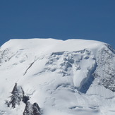
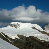
Alphubel
Alphubel

