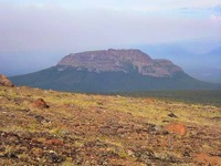
Anahim Peak guide
- Elevation: 1897 m
- Difficulty:
- Best months to climb:
- Convenient center:
Anahim Peak Climbing Notes
Tyler Hamm from CANADA writes:
Climbed the south east end of the mountain on Saturday, June 21st. We left Anahim Lake and headed west on Hwy 20. Approx. 15 kms outside Anahim Lake turn right on the Beef Trail. Approx. 26 kms up this road, just past the 52km board, there is an old cutblock that gives the closest access to this end of the peak. We used google earth to give us a rough idea of where to go and just headed out.
We ended up bushwacking our way up until we found a rock chute which made for steep, but relatively easy climbing. We came up to a little valley between the actual summit and a plateau on the south end. From there, we made our way west until we came upon some steep, but decent hiking up to the top.
Upon return to Anahim Lake, we found out there is actually a horse trail on the north end of the mountain accessible off the Dean River Rd. Although undoubtedly an easier route, we made summit in 3 1/2 hrs with a descent.
2014-06-22 |
Click here to submit your own climbing note for Anahim Peak
|

Select Anahim Peak Location Map Detail:
Use this relief map to navigate to mountain peaks in the area of Anahim Peak.
10 other mountain peaks closest to Anahim Peak:


 Like us
 Follow us
 Follow us