
– Lat/Long: 56.57° N 4.22° W
 Ben Lawers
Weather Forecast, United KingdomIssued: 12 am Mon 28 Apr Local TimeUpdates in: hr min sUpdate imminent
Ben Lawers Weather Forecast, United Kingdom
Issued: 12 am Mon 28 Apr Local Time
Updates in:
Update imminent hr min s

Issued: 12 am Mon 28 Apr Local Time
Updates in:
Update imminent hr min s
Days 1–4 Weather SummaryMostly dry. Very mild (max 16°C on Wed morning, min 9°C on Sun night). Wind will be generally light. | Days 5–7 Weather SummaryMostly dry. Very mild (max 14°C on Sat morning, min 5°C on Thu night). Wind will be generally light. | ||||||||||||||||||
Monday 28 | Tuesday 29 | Wednesday 30 | Thursday 1 | Friday 2 | Saturday 3 | ||||||||||||||
night | AM | PM | night | AM | PM | night | AM | PM | night | AM | PM | night | AM | PM | night | AM | PM | night | |
light rain | light rain | light rain | cloudy | cloudy | cloudy | some clouds | some clouds | some clouds | rain shwrs | light rain | clear | clear | clear | clear | clear | some clouds | cloudy | cloudy | |
km/h | |||||||||||||||||||
 |  |  |  |  |  |  | |||||||||||||
— | — | — | — | — | — | — | — | — | — | — | — | — | — | — | — | — | — | — | |
0.5 | 0.1 | 0.2 | — | — | — | — | — | — | 0.3 | 0.1 | — | — | — | — | — | — | — | — | |
max°C | 9 | 10 | 12 | 11 | 14 | 14 | 12 | 16 | 16 | 12 | 10 | 10 | 6 | 10 | 12 | 10 | 14 | 14 | 9 |
min°C | 9 | 9 | 12 | 10 | 12 | 14 | 10 | 14 | 15 | 10 | 10 | 8 | 5 | 7 | 12 | 8 | 12 | 11 | 7 |
6 | 7 | 11 | 9 | 11 | 14 | 10 | 14 | 14 | 8 | 8 | 5 | 3 | 7 | 12 | 7 | 12 | 11 | 7 | |
2400 | 2350 | 2350 | 2550 | 2600 | 2650 | 2750 | 2600 | 2650 | 2500 | 1900 | 1900 | 1900 | 1750 | 2250 | 2700 | 2600 | 2750 | 2650 | |
Cloud base (m) | 450 | 400 | 650 | 2700 | 3050 | 6050 | 6400 | 6650 | 1700 | 900 | 650 | 1550 | 800 | 750 | 1600 | 2450 | 1750 | 750 | |
— | 5:39 | — | — | 5:35 | — | — | 5:33 | — | — | 5:31 | — | — | 5:28 | — | — | 5:26 | — | — | |
— | — | 8:51 | — | — | 8:52 | — | — | 8:54 | — | — | 8:57 | — | — | 8:59 | — | — | 9:00 | — | |
Loading...
Ben Lawers Weather (Days 0-3):
The weather forecast for Ben Lawers is: Mostly dry. Very mild (max 16°C on Wed morning, min 9°C on Sun night). Wind will be generally light.
Ben Lawers Weather (Days 3-6):
Mostly dry. Very mild (max 14°C on Sat morning, min 5°C on Thu night). Wind will be generally light.
This table gives the weather forecast for Ben Lawers at the specific elevation of 500 m. Our advanced weather models allow us to provide distinct weather forecasts for several elevations of Ben Lawers. To see the weather forecasts for the other elevations, use the tab navigation above the table. For a wider overview of the weather, consult the Weather Map of United Kingdom.
| Weather Station | Temp. | Weather | Wind | Gusts | Cloud / Visibility |
|---|---|---|---|---|---|
SAIS Drumochter | |||||
StrathallenAirfield | |||||
TullochBridge | |||||
SAIS C Meagaidh area | |||||
Aonach Mor | |||||
SAIS Aonach Mor | |||||
657 | |||||
T17- Nevis Range |
* NOTE: not all weather observatories update at the same frequency which is the reason why some locations may show data from stations that are further away than known closer ones.
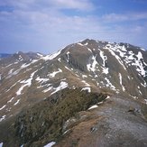
Ben Lawers Photos
View all
Grampians photos (156) |
Scottish Highlands photos (288) |
photos from mountains in United Kingdom (1959) |
all photos
 Upload new photo
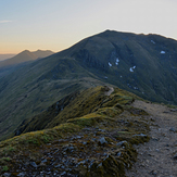
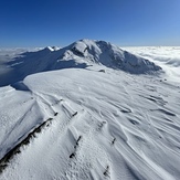
Ben Lawers
Ben Lawers
Ben Lawers

