– Lat/Long: 45.27° N 70.84° W
 Boundary Peak (Maine)
Weather Forecast, CanadaIssued: 7 pm Fri 25 Apr Local TimeUpdates in: hr min sUpdate imminent
Boundary Peak (Maine) Weather Forecast, Canada
Issued: 7 pm Fri 25 Apr Local Time
Updates in:
Update imminent hr min s

Issued: 7 pm Fri 25 Apr Local Time
Updates in:
Update imminent hr min s
Days 1–4 Weather SummaryMild with heavy rain (total 22mm), heaviest during Sat morning. Becoming colder with a moderate fall of snow heaviest on Sun afternoon. Freeze-thaw conditions (max 8°C on Sat afternoon, min -3°C on Sun afternoon). Winds increasing (light winds from the WSW on Sat night, gales from the N by Sun night). | Days 5–7 Weather SummarySome drizzle, heaviest during Tue night. Freeze-thaw conditions (max 13°C on Tue night, min -4°C on Wed afternoon). Winds increasing (light winds from the WNW on Mon night, stormy winds from the W by Wed morning). | ||||||||||||||||||
Saturday 26 | Sunday 27 | Monday 28 | Tuesday 29 | Wednesday 30 | Thursday 1 | ||||||||||||||
night | AM | PM | night | AM | PM | night | AM | PM | night | AM | PM | night | AM | PM | night | AM | PM | night | |
light rain | heavy rain | mod. rain | light snow | light snow | mod. snow | snow shwrs | clear | rain shwrs | some clouds | some clouds | rain shwrs | light rain | light rain | cloudy | clear | clear | clear | some clouds | |
km/h | |||||||||||||||||||
 |  |  |  |  |  |  | |||||||||||||
— | — | — | 1.0 | 1.0 | 6 | 6 | — | — | — | — | — | — | — | — | — | — | — | — | |
1.9 | 11 | 5 | 4 | — | — | — | — | 0.2 | — | — | 0.1 | 1.4 | 0.4 | — | — | — | — | — | |
max°C | 7 | 7 | 8 | 8 | 0 | -2 | 1 | 4 | 5 | 6 | 10 | 12 | 13 | 10 | -2 | -2 | 0 | 3 | 5 |
min°C | 6 | 7 | 8 | 2 | -1 | -3 | -2 | 2 | 4 | 5 | 8 | 12 | 12 | -2 | -4 | -4 | -1 | 2 | 3 |
0 | 1 | 3 | -3 | -7 | -13 | -12 | -5 | -1 | 0 | 4 | 9 | 8 | -13 | -16 | -15 | -10 | -5 | -2 | |
2550 | 2850 | 3000 | 2050 | 950 | 650 | 1300 | 1850 | 2050 | 2600 | 3300 | 3500 | 3450 | 900 | 950 | 550 | 1150 | 2450 | 2700 | |
Cloud base (m) | 550 | 450 | 450 | 450 | 450 | 450 | 500 | 550 | 1650 | 3000 | 4450 | 2250 | 650 | 600 | 450 | 550 | 8500 | 7150 | |
— | 5:39 | — | — | 5:37 | — | — | 5:37 | — | — | 5:35 | — | — | 5:33 | — | — | 5:31 | — | — | |
— | — | 7:42 | — | — | 7:44 | — | — | 7:45 | — | — | 7:45 | — | — | 7:46 | — | — | 7:49 | — | |
Loading...
Boundary Peak (Maine) Weather (Days 0-3):
The weather forecast for Boundary Peak (Maine) is: Mild with heavy rain (total 22mm), heaviest during Sat morning. Becoming colder with a moderate fall of snow heaviest on Sun afternoon. Freeze-thaw conditions (max 8°C on Sat afternoon, min -3°C on Sun afternoon). Winds increasing (light winds from the WSW on Sat night, gales from the N by Sun night).
Boundary Peak (Maine) Weather (Days 3-6):
Some drizzle, heaviest during Tue night. Freeze-thaw conditions (max 13°C on Tue night, min -4°C on Wed afternoon). Winds increasing (light winds from the WNW on Mon night, stormy winds from the W by Wed morning).
This table gives the weather forecast for Boundary Peak (Maine) at the specific elevation of 1175 m. Our advanced weather models allow us to provide distinct weather forecasts for several elevations of Boundary Peak (Maine). To see the weather forecasts for the other elevations, use the tab navigation above the table. For a wider overview of the weather, consult the Weather Map of Maine.
* NOTE: not all weather observatories update at the same frequency which is the reason why some locations may show data from stations that are further away than known closer ones.
Boundary Peak (Maine) Photos
View all
photos (26) |
Appalachians photos (861) |
photos from mountains in Canada (441) |
all photos
 Upload new photo
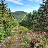
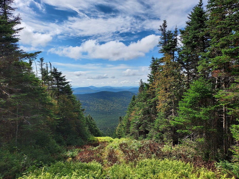
Looking South - East from Boundary Peak
Boundary Peak

