– Lat/Long: 65.83° N 18.73° W
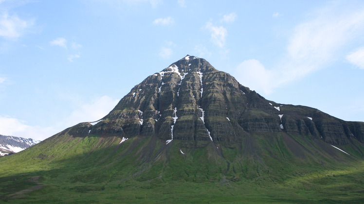
 Búrfellshyrna
Weather Forecast, IcelandIssued: 5 am Sun 30 Mar Local TimeUpdates in: hr min sUpdate imminent
Búrfellshyrna Weather Forecast, Iceland
Issued: 5 am Sun 30 Mar Local Time
Updates in:
Update imminent hr min s

Issued: 5 am Sun 30 Mar Local Time
Updates in:
Update imminent hr min s
Days 1–3 Weather SummaryA dusting of new snow. Temperatures will be below freezing (max 0°C on Mon morning, min -7°C on Sun morning). Winds decreasing (strong winds from the SSW on Sun night, calm by Tue night). | Days 4–6 Weather SummaryMostly dry. Freeze-thaw conditions (max 5°C on Fri morning, min -6°C on Wed night). Winds decreasing (strong winds from the WSW on Wed afternoon, calm by Fri afternoon). | Days 7–9 Weather SummaryLight rain (total 3mm), mostly falling on Mon morning. Mild temperatures (max 7°C on Sun afternoon, min 5°C on Sat morning). Wind will be generally light. | Days 10–12 Weather SummaryMostly dry. Mild temperatures (max 9°C on Thu afternoon, min 6°C on Tue morning). Wind will be generally light. | |||||||||||||||||||||||||||||||||
Sunday 30 | Monday 31 | Tuesday 1 | Wednesday 2 | Thursday 3 | Friday 4 | Saturday 5 | Sunday 6 | Monday 7 | Tuesday 8 | Wednesday 9 | Thursday 10 | |||||||||||||||||||||||||
AM | PM | night | AM | PM | night | AM | PM | night | AM | PM | night | AM | PM | night | AM | PM | night | AM | PM | night | AM | PM | night | AM | PM | night | AM | PM | night | AM | PM | night | AM | PM | night | |
cloudy | snow shwrs | snow shwrs | some clouds | some clouds | cloudy | cloudy | cloudy | cloudy | cloudy | cloudy | cloudy | cloudy | some clouds | some clouds | some clouds | some clouds | clear | some clouds | cloudy | rain shwrs | light rain | some clouds | some clouds | light rain | cloudy | some clouds | cloudy | some clouds | clear | clear | some clouds | clear | clear | some clouds | some clouds | |
km/h | ||||||||||||||||||||||||||||||||||||
 |  |  |  |  |  |  |  |  |  |  |  | |||||||||||||||||||||||||
— | 1.0 | 1.0 | — | — | — | — | — | — | — | — | — | — | — | — | — | — | — | — | — | — | — | — | — | — | — | — | — | — | — | — | — | — | — | — | — | |
— | — | — | — | — | — | — | — | — | — | — | — | — | — | — | — | — | — | — | — | 0.1 | 0.1 | — | — | 2 | — | — | — | — | — | — | — | — | — | — | — | |
max°C | -4 | -3 | -1 | 0 | 0 | -2 | 0 | 0 | -2 | -2 | -2 | -3 | 0 | 1 | 3 | 5 | 5 | 4 | 6 | 5 | 5 | 6 | 7 | 7 | 6 | 6 | 6 | 7 | 7 | 7 | 8 | 8 | 8 | 8 | 9 | 8 |
min°C | -7 | -4 | -2 | -1 | -1 | -3 | -2 | 0 | -3 | -3 | -3 | -6 | -1 | 1 | -1 | 4 | 4 | 3 | 5 | 5 | 5 | 6 | 6 | 7 | 6 | 6 | 5 | 6 | 6 | 7 | 7 | 8 | 7 | 7 | 9 | 7 |
-10 | -8 | -7 | -9 | -7 | -9 | -5 | -3 | -3 | -8 | -11 | -13 | -6 | -2 | -4 | 2 | 3 | 2 | 2 | 2 | 3 | 4 | 4 | 5 | 4 | 4 | 5 | 5 | 5 | 6 | 6 | 8 | 6 | 6 | 8 | 5 | |
0 | 0 | 200 | 550 | 450 | 0 | 100 | 550 | 0 | 0 | 250 | 0 | 300 | 650 | 0 | 1300 | 1400 | 2000 | 2000 | 1850 | 1800 | 1900 | 2150 | 2050 | 1700 | 1700 | 2000 | 2200 | 2450 | 2650 | 2750 | 2750 | 2550 | 2450 | 2400 | 2400 | |
Cloud base (m) | 550 | 750 | 450 | 500 | 550 | 550 | 550 | 550 | 650 | 800 | 600 | 650 | 700 | 650 | 2300 | 900 | 750 | 4750 | 800 | 600 | 650 | 600 | 600 | 600 | 600 | 800 | 1750 | 650 | 4100 | 9250 | 650 | 600 | 7600 | |||
6:37 | — | — | 6:33 | — | — | 6:28 | — | — | 6:24 | — | — | 6:22 | — | — | 6:18 | — | — | 6:13 | — | — | 6:09 | — | — | 6:05 | — | — | 6:01 | — | — | 5:58 | — | — | 5:54 | — | — | |
— | 8:02 | — | — | 8:06 | — | — | 8:08 | — | — | 8:13 | — | — | 8:15 | — | — | 8:19 | — | — | 8:22 | — | — | 8:25 | — | — | 8:29 | — | — | 8:31 | — | — | 8:36 | — | — | 8:38 | — | |
Búrfellshyrna Weather (Days 0-3):
The weather forecast for Búrfellshyrna is: A dusting of new snow. Temperatures will be below freezing (max 0°C on Mon morning, min -7°C on Sun morning). Winds decreasing (strong winds from the SSW on Sun night, calm by Tue night).
Búrfellshyrna Weather (Days 3-6):
Mostly dry. Freeze-thaw conditions (max 5°C on Fri morning, min -6°C on Wed night). Winds decreasing (strong winds from the WSW on Wed afternoon, calm by Fri afternoon).
Búrfellshyrna Weather (Days 6-9):
Light rain (total 3mm), mostly falling on Mon morning. Mild temperatures (max 7°C on Sun afternoon, min 5°C on Sat morning). Wind will be generally light.
This table gives the weather forecast for Búrfellshyrna at the specific elevation of 500 m. Our advanced weather models allow us to provide distinct weather forecasts for several elevations of Búrfellshyrna. To see the weather forecasts for the other elevations, use the tab navigation above the table. For a wider overview of the weather, consult the Weather Map of Iceland.
Búrfellshyrna Photos
View all
Iceland photos (5) |
Atlantic Islands photos (75) |
photos from mountains in Iceland (25) |
all photos
 Upload new photo
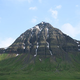
Búrfellshyrna

