– Lat/Long: 45.29° N 5.79° E
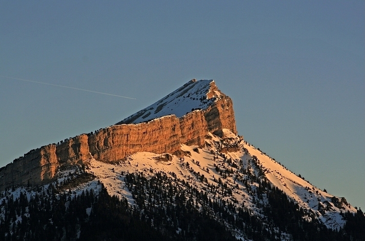
 Chamechaude
Weather Forecast, FranceIssued: 1 pm Wed 02 Apr Local TimeUpdates in: hr min sUpdate imminent
Chamechaude Weather Forecast, France
Issued: 1 pm Wed 02 Apr Local Time
Updates in:
Update imminent hr min s

Issued: 1 pm Wed 02 Apr Local Time
Updates in:
Update imminent hr min s
Days 1–4 Weather SummaryMostly dry. Very mild (max 11°C on Fri afternoon, min 4°C on Wed night). Wind will be generally light. | Days 5–7 Weather SummaryMostly dry. Very mild (max 10°C on Sat afternoon, min 2°C on Tue morning). Wind will be generally light. | ||||||||||||||||
Wed 2 | Thursday 3 | Friday 4 | Saturday 5 | Sunday 6 | Monday 7 | ||||||||||||
PM | night | AM | PM | night | AM | PM | night | AM | PM | night | AM | PM | night | AM | PM | night | |
some clouds | rain shwrs | clear | some clouds | some clouds | some clouds | some clouds | rain shwrs | clear | rain shwrs | clear | clear | clear | clear | clear | clear | clear | |
km/h | |||||||||||||||||
 |  |  |  |  |  | ||||||||||||
— | — | — | — | — | — | — | — | — | — | — | — | — | — | — | — | — | |
— | 0.1 | — | — | — | — | — | 0.2 | — | 0.2 | — | — | — | — | — | — | — | |
max°C | 7 | 5 | 7 | 9 | 8 | 8 | 11 | 9 | 7 | 10 | 9 | 5 | 6 | 6 | 4 | 6 | 5 |
min°C | 5 | 4 | 6 | 8 | 7 | 8 | 10 | 8 | 7 | 9 | 7 | 4 | 5 | 5 | 3 | 5 | 3 |
5 | 4 | 5 | 8 | 7 | 8 | 10 | 8 | 7 | 8 | 4 | 2 | 3 | 4 | 3 | 4 | 0 | |
2250 | 2300 | 2650 | 2900 | 3000 | 3100 | 3000 | 2800 | 2650 | 2800 | 2900 | 3100 | 2850 | 2650 | 2550 | 2550 | 2450 | |
Cloud base (m) | 2150 | 2100 | 3200 | 2450 | 5800 | 4150 | 2050 | 2250 | 2850 | 700 | 1750 | 2650 | 2250 | 2100 | 1750 | ||
— | — | 7:13 | — | — | 7:11 | — | — | 7:11 | — | — | 7:09 | — | — | 7:07 | — | — | |
— | 8:05 | — | — | 8:06 | — | — | 8:07 | — | — | 8:08 | — | — | 8:09 | — | — | 8:10 | |
Chamechaude Weather (Days 0-3):
The weather forecast for Chamechaude is: Mostly dry. Very mild (max 11°C on Fri afternoon, min 4°C on Wed night). Wind will be generally light.
Chamechaude Weather (Days 3-6):
Mostly dry. Very mild (max 10°C on Sat afternoon, min 2°C on Tue morning). Wind will be generally light.
This table gives the weather forecast for Chamechaude at the specific elevation of 1500 m. Our advanced weather models allow us to provide distinct weather forecasts for several elevations of Chamechaude. To see the weather forecasts for the other elevations, use the tab navigation above the table. For a wider overview of the weather, consult the Weather Map of France.
| Weather Station | Temp. | Weather | Wind | Gusts | Cloud / Visibility |
|---|---|---|---|---|---|
TMX clos giraud g2 | |||||
TC Montfrais g4 | |||||
Aéroport Grenoble-Isère Grenobl / aint Geoirs Airport | |||||
1309 | |||||
Plan Bouchet ORELLE | |||||
1308 | |||||
Depart Geant | |||||
TC GRANGETTES P4 | |||||
Eclipse |
* NOTE: not all weather observatories update at the same frequency which is the reason why some locations may show data from stations that are further away than known closer ones.
Chamechaude Photos
View all
Chartreuse Mountains photos (2) |
Alps photos (1455) |
photos from mountains in France (280) |
all photos
 Upload new photo
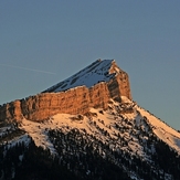
Chamechaude

