– Lat/Long: 16.17° S 68.25° W
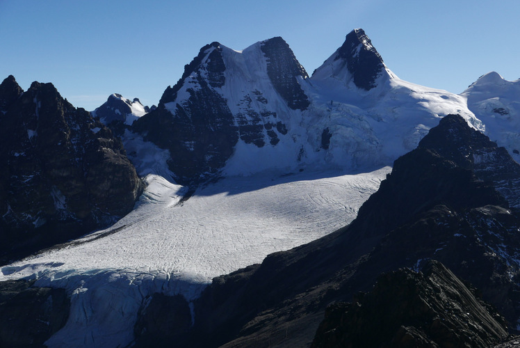
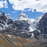
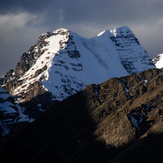
 Condoriri
Weather Forecast, BoliviaIssued: 1 pm Sat 04 Apr Local TimeUpdates in: hr min sUpdate imminent
Issued: 1 pm Sat 04 Apr Local Time
Updates in:
Update imminent hr min s

Issued: 1 pm Sat 04 Apr Local Time
Updates in:
Update imminent hr min s
Days 1–4 Weather SummaryA dusting of new snow. Temperatures will be below freezing (max -1°C on Mon morning, min -5°C on Sat night). Wind will be generally light. | Days 5–7 Weather SummaryA light covering of new snow mostly falling on Tue afternoon. Temperatures will be below freezing (max -1°C on Thu afternoon, min -4°C on Tue night). Wind will be generally light. | ||||||||||||||||
Sat 4 | Sunday 5 | Monday 6 | Tuesday 7 | Wednesday 8 | Thursday 9 | ||||||||||||
PM | night | AM | PM | night | AM | PM | night | AM | PM | night | AM | PM | night | AM | PM | night | |
snow shwrs | some clouds | some clouds | some clouds | some clouds | clear | snow shwrs | clear | some clouds | snow shwrs | some clouds | some clouds | snow shwrs | some clouds | some clouds | snow shwrs | some clouds | |
km/h | |||||||||||||||||
 |  |  |  |  |  | ||||||||||||
2 | — | — | — | — | — | 1 | — | — | 2 | — | — | 2 | — | — | 2 | — | |
— | — | — | — | — | — | — | — | — | — | — | — | — | — | — | — | — | |
max °C | -2 | -3 | -2 | -2 | -3 | -1 | -1 | -3 | -2 | -2 | -3 | -2 | -2 | -3 | -2 | -1 | -3 |
min °C | -3 | -5 | -4 | -3 | -4 | -3 | -1 | -4 | -3 | -2 | -4 | -3 | -2 | -3 | -3 | -1 | -3 |
-6 | -8 | -8 | -6 | -4 | -6 | -4 | -4 | -5 | -5 | -6 | -7 | -6 | -6 | -7 | -4 | -3 | |
5150 | 4700 | 5250 | 5200 | 4900 | 5450 | 5450 | 4950 | 5350 | 5300 | 5000 | 5300 | 5400 | 5150 | 5400 | 5500 | 5100 | |
Cloud base (m) | 4900 | 5100 | 5300 | 5100 | 4950 | 7150 | 5850 | 5600 | 5500 | 5500 | 5150 | 5400 | 5300 | 5150 | 5150 | 5450 | 5400 |
— | — | 6:39 | — | — | 6:39 | — | — | 6:39 | — | — | 6:39 | — | — | 6:39 | — | — | |
6:31 | — | — | 6:30 | — | — | 6:30 | — | — | 6:30 | — | — | 6:29 | — | — | 6:28 | — | |
Loading...
Condoriri Weather (Days 0-3):
The weather forecast for Condoriri is: A dusting of new snow. Temperatures will be below freezing (max -1°C on Mon morning, min -5°C on Sat night). Wind will be generally light.
Condoriri Weather (Days 3-6):
A light covering of new snow mostly falling on Tue afternoon. Temperatures will be below freezing (max -1°C on Thu afternoon, min -4°C on Tue night). Wind will be generally light.
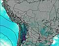
This table gives the weather forecast for Condoriri at the specific elevation of 5648 m. Our advanced weather models allow us to provide distinct weather forecasts for several elevations of Condoriri. To see the weather forecasts for the other elevations, use the tab navigation above the table. For a wider overview of the weather, consult the Weather Map of Bolivia.
| Weather Station | Temp. | Weather | Wind | Gusts | Cloud / Visibility |
|---|---|---|---|---|---|
lightning 10km NNE of Chuquitira | |||||
Cochabamba | |||||
Putre | |||||
Cochabamb / orge Wilsterman Airport |
* NOTE: not all weather observatories update at the same frequency which is the reason why some locations may show data from stations that are further away than known closer ones.
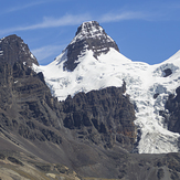
Condoriri Photos
View all
Bolivian Andes photos (96) |
Andes photos (1018) |
photos from mountains in Bolivia (84) |
all photos
 Upload new photo
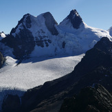
 See 9 more Condoriri photos
Condoriri
Condoriri desde la Laguna Chiar Khota
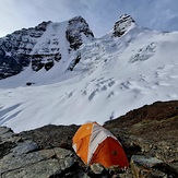
Ala Izquierda Condoriri High Camp
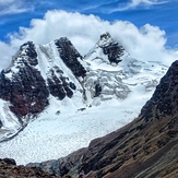
Nevado Condoriri
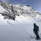
Ala Izquierda and Cabezza del Condor
Condoriri en verano