
– Lat/Long: 43.23° N 41.72° E
 Dombai-Ulgen
Weather Forecast, GeorgiaIssued: 2 am Fri 25 Apr Local TimeUpdates in: hr min sUpdate imminent
Dombai-Ulgen Weather Forecast, Georgia
Issued: 2 am Fri 25 Apr Local Time
Updates in:
Update imminent hr min s

Issued: 2 am Fri 25 Apr Local Time
Updates in:
Update imminent hr min s
Days 1–3 Weather SummaryA heavy fall of snow, heaviest during Sun night. Temperatures will be well below freezing (max -7°C on Fri morning, min -13°C on Sun night). Winds increasing (light winds from the SSW on Sat night, strong winds from the WSW by Sun night). | Days 4–6 Weather SummaryA dusting of new snow. Temperatures will be below freezing (max -5°C on Wed night, min -14°C on Mon morning). Mainly fresh winds. | |||||||||||||||||
Friday 25 | Saturday 26 | Sunday 27 | Monday 28 | Tuesday 29 | Wednesday 30 | |||||||||||||
AM | PM | night | AM | PM | night | AM | PM | night | AM | PM | night | AM | PM | night | AM | PM | night | |
heavy snow | snow shwrs | snow shwrs | snow shwrs | snow shwrs | snow shwrs | snow shwrs | snow shwrs | snow shwrs | snow shwrs | clear | clear | clear | clear | clear | cloudy | clear | clear | |
km/h | ||||||||||||||||||
 |  |  |  |  |  | |||||||||||||
14 | 13 | 3 | 2.0 | 2.0 | 2.0 | 2.0 | 3 | 50 | 2.0 | — | — | — | — | — | — | — | — | |
— | — | — | — | — | — | — | — | — | — | — | — | — | — | — | — | — | — | |
max°C | -7 | -9 | -9 | -9 | -8 | -9 | -11 | -11 | -11 | -14 | -12 | -9 | -8 | -8 | -7 | -7 | -7 | -5 |
min°C | -8 | -9 | -10 | -10 | -8 | -10 | -11 | -11 | -13 | -14 | -13 | -10 | -9 | -8 | -7 | -8 | -8 | -7 |
-18 | -18 | -18 | -20 | -17 | -17 | -19 | -20 | -24 | -25 | -21 | -16 | -16 | -14 | -14 | -15 | -15 | -14 | |
2950 | 2750 | 2400 | 2600 | 2850 | 2650 | 2500 | 2450 | 2250 | 1950 | 2000 | 1250 | 2700 | 2850 | 3100 | 3000 | 2950 | 3200 | |
Cloud base (m) | 2500 | 2450 | 2900 | 2500 | 2750 | 2600 | 2450 | 2450 | 2450 | 2500 | 2450 | 2500 | 2600 | 2650 | 2650 | |||
5:15 | — | — | 5:13 | — | — | 5:11 | — | — | 5:11 | — | — | 5:09 | — | — | 5:07 | — | — | |
— | 7:07 | — | — | 7:07 | — | — | 7:08 | — | — | 7:09 | — | — | 7:12 | — | — | 7:13 | — | |
Loading...
Dombai-Ulgen Weather (Days 0-3):
The weather forecast for Dombai-Ulgen is: A heavy fall of snow, heaviest during Sun night. Temperatures will be well below freezing (max -7°C on Fri morning, min -13°C on Sun night). Winds increasing (light winds from the SSW on Sat night, strong winds from the WSW by Sun night).
Dombai-Ulgen Weather (Days 3-6):
A dusting of new snow. Temperatures will be below freezing (max -5°C on Wed night, min -14°C on Mon morning). Mainly fresh winds.
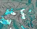
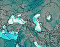
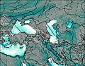
This table gives the weather forecast for Dombai-Ulgen at the specific elevation of 4046 m. Our advanced weather models allow us to provide distinct weather forecasts for several elevations of Dombai-Ulgen. To see the weather forecasts for the other elevations, use the tab navigation above the table. For a wider overview of the weather, consult the Weather Map of Georgia.
| Weather Station | Temp. | Weather | Wind | Gusts | Cloud / Visibility |
|---|---|---|---|---|---|
lightning 32km N of Tqvarch'eli | |||||
lightning 37km NNE of Sukhumi | |||||
Mestia Queen Tamar Airport | |||||
lightning 34km S of Bichvint'a | |||||
Ambrolauri Airport | |||||
Mineral nye Vody (37054 -0) |
* NOTE: not all weather observatories update at the same frequency which is the reason why some locations may show data from stations that are further away than known closer ones.

