
– Lat/Long: 43.16° N 109.63° W
 Doublet Peak
Weather Forecast, United StatesIssued: 11 am Tue 09 Sep Local TimeUpdates in: hr min sUpdate imminent
Issued: 11 am Tue 09 Sep Local Time
Updates in:
Update imminent hr min s

Issued: 11 am Tue 09 Sep Local Time
Updates in:
Update imminent hr min s
Days 1–3 Weather SummarySome drizzle, heaviest during Tue afternoon. Freeze-thaw conditions (max 6°C on Wed afternoon, min -2°C on Thu night). Winds increasing (light winds from the SW on Tue morning, strong winds from the SW by Thu afternoon). | Days 4–6 Weather SummaryA dusting of new snow. Freeze-thaw conditions (max 1°C on Fri morning, min -3°C on Sat night). Wind will be generally light. | |||||||||||||||||
Tuesday 9 | Wednesday 10 | Thursday 11 | Friday 12 | Saturday 13 | Sunday 14 | |||||||||||||
AM | PM | night | AM | PM | night | AM | PM | night | AM | PM | night | AM | PM | night | AM | PM | night | |
light rain | rain shwrs | some clouds | rain shwrs | rain shwrs | some clouds | clear | rain shwrs | some clouds | some clouds | some clouds | clear | some clouds | snow shwrs | some clouds | some clouds | some clouds | clear | |
km/h | ||||||||||||||||||
 |  |  |  |  |  | |||||||||||||
— | — | — | — | — | — | — | — | — | — | — | — | — | 1 | — | — | — | — | |
0.2 | 0.4 | — | 0.2 | 0.1 | — | — | 0.2 | — | — | — | — | — | — | — | — | — | — | |
max°C | 3 | 4 | 2 | 4 | 6 | 2 | 2 | 2 | -1 | 1 | 1 | -1 | 0 | 1 | -2 | 0 | 1 | 0 |
min°C | 0 | 3 | 1 | 2 | 6 | -1 | 1 | 1 | -2 | 0 | 0 | -2 | -1 | -1 | -3 | -2 | 1 | -1 |
-4 | -1 | -4 | -2 | 1 | -7 | -6 | -5 | -8 | -6 | -4 | -5 | -4 | -4 | -6 | -6 | -4 | -6 | |
4150 | 4600 | 4350 | 4450 | 4800 | 4450 | 4250 | 4450 | 4000 | 4150 | 4300 | 3950 | 4000 | 4250 | 3850 | 3900 | 4200 | 4150 | |
Cloud base (m) | 5250 | 4950 | 5600 | 5500 | 4900 | 8900 | 4100 | 5000 | 5300 | 7600 | 5050 | 5150 | 5150 | 4400 | ||||
6:50 | — | — | 6:52 | — | — | 6:52 | — | — | 6:54 | — | — | 6:54 | — | — | 6:56 | — | — | |
— | 7:39 | — | — | 7:37 | — | — | 7:36 | — | — | 7:34 | — | — | 7:31 | — | — | 7:30 | — | |
Loading...
Doublet Peak Weather (Days 0-3):
The weather forecast for Doublet Peak is: Some drizzle, heaviest during Tue afternoon. Freeze-thaw conditions (max 6°C on Wed afternoon, min -2°C on Thu night). Winds increasing (light winds from the SW on Tue morning, strong winds from the SW by Thu afternoon).
Doublet Peak Weather (Days 3-6):
A dusting of new snow. Freeze-thaw conditions (max 1°C on Fri morning, min -3°C on Sat night). Wind will be generally light.
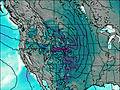
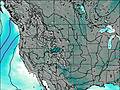
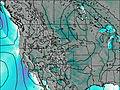
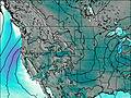
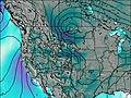
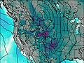
This table gives the weather forecast for Doublet Peak at the specific elevation of 4145 m. Our advanced weather models allow us to provide distinct weather forecasts for several elevations of Doublet Peak. To see the weather forecasts for the other elevations, use the tab navigation above the table. For a wider overview of the weather, consult the Weather Map of Wyoming.
| Weather Station | Temp. | Weather | Wind | Gusts | Cloud / Visibility |
|---|---|---|---|---|---|
lightning 60km N of Pinedale | |||||
Pinedale- Ralph Wenz Field Airport (WY) | |||||
Big Piney Airport |
* NOTE: not all weather observatories update at the same frequency which is the reason why some locations may show data from stations that are further away than known closer ones.