
– Lat/Long: 62.50° N 10.47° E
 Eidsfjell
Weather Forecast, NorwayIssued: 7 am Mon 28 Apr Local TimeUpdates in: hr min sUpdate imminent
Eidsfjell Weather Forecast, Norway
Issued: 7 am Mon 28 Apr Local Time
Updates in:
Update imminent hr min s

Issued: 7 am Mon 28 Apr Local Time
Updates in:
Update imminent hr min s
Days 1–3 Weather SummaryLight rain (total 2mm), mostly falling on Mon morning. Mild temperatures (max 9°C on Tue night, min 3°C on Tue night). Winds decreasing (strong winds from the NW on Mon afternoon, calm by Wed night). | Days 4–6 Weather SummaryLight rain (total 6mm) at first, then becoming colder with a dusting of snow on Sat morning. Freeze-thaw conditions (max 15°C on Thu afternoon, min 0°C on Sat night). Mainly gales. | |||||||||||||||||
Monday 28 | Tuesday 29 | Wednesday 30 | Thursday 1 | Friday 2 | Saturday 3 | |||||||||||||
AM | PM | night | AM | PM | night | AM | PM | night | AM | PM | night | AM | PM | night | AM | PM | night | |
rain shwrs | rain shwrs | rain shwrs | light rain | light rain | rain shwrs | rain shwrs | rain shwrs | light rain | cloudy | cloudy | rain shwrs | light rain | rain shwrs | rain shwrs | snow shwrs | rain shwrs | some clouds | |
km/h | ||||||||||||||||||
 |  |  |  |  |  | |||||||||||||
— | — | — | — | — | — | — | — | — | — | — | — | — | — | — | 1.0 | — | — | |
1.0 | 0.1 | 0.1 | 0.2 | 0.2 | 0.2 | 0.2 | 0.1 | 0.3 | — | — | 0.9 | 3 | 0.8 | 0.8 | 0.1 | 0.8 | — | |
max°C | 7 | 8 | 7 | 6 | 7 | 9 | 6 | 8 | 9 | 9 | 15 | 10 | 4 | 6 | 5 | 2 | 3 | 1 |
min°C | 5 | 7 | 4 | 4 | 6 | 3 | 4 | 7 | 7 | 8 | 11 | 3 | 4 | 4 | 3 | 1 | 2 | 0 |
2 | 2 | 0 | -1 | 3 | -3 | -2 | 3 | 4 | 5 | 8 | -1 | 0 | -2 | -2 | -8 | -6 | -8 | |
1650 | 1500 | 1250 | 1300 | 1300 | 1050 | 1250 | 1500 | 1850 | 2150 | 2350 | 1450 | 1050 | 1250 | 1200 | 800 | 800 | 550 | |
Cloud base (m) | 600 | 700 | 850 | 650 | 1600 | 1550 | 900 | 1950 | 1850 | 2700 | 1950 | 4400 | 600 | 1450 | 1800 | 650 | 800 | 700 |
5:13 | — | — | 5:09 | — | — | 5:05 | — | — | 5:03 | — | — | 5:00 | — | — | 4:56 | — | — | |
— | — | 9:20 | — | — | 9:22 | — | — | 9:25 | — | — | 9:28 | — | — | 9:30 | — | — | 9:34 | |
Loading...
Eidsfjell Weather (Days 0-3):
The weather forecast for Eidsfjell is: Light rain (total 2mm), mostly falling on Mon morning. Mild temperatures (max 9°C on Tue night, min 3°C on Tue night). Winds decreasing (strong winds from the NW on Mon afternoon, calm by Wed night).
Eidsfjell Weather (Days 3-6):
Light rain (total 6mm) at first, then becoming colder with a dusting of snow on Sat morning. Freeze-thaw conditions (max 15°C on Thu afternoon, min 0°C on Sat night). Mainly gales.
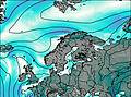
This table gives the weather forecast for Eidsfjell at the specific elevation of 500 m. Our advanced weather models allow us to provide distinct weather forecasts for several elevations of Eidsfjell. To see the weather forecasts for the other elevations, use the tab navigation above the table. For a wider overview of the weather, consult the Weather Map of Norway.

