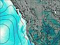
– Lat/Long: 48.54° N 121.13° W
 Eldorado Peak
Weather Forecast, United StatesIssued: 10 am Tue 01 Apr Local TimeUpdates in: hr min sUpdate imminent
Eldorado Peak Weather Forecast, United States
Issued: 10 am Tue 01 Apr Local Time
Updates in:
Update imminent hr min s

Issued: 10 am Tue 01 Apr Local Time
Updates in:
Update imminent hr min s
Days 1–3 Weather SummaryA dusting of new snow. Temperatures will be below freezing (max -2°C on Thu afternoon, min -7°C on Tue night). Wind will be generally light. | Days 4–6 Weather SummaryA dusting of new snow. Freeze-thaw conditions (max 5°C on Sat afternoon, min -4°C on Sun night). Wind will be generally light. | Days 7–9 Weather SummaryA heavy fall of snow, heaviest during Tue morning. Temperatures will be below freezing (max 0°C on Wed night, min -5°C on Mon morning). Wind will be generally light. | Days 10–12 Weather SummaryLight rain (total 9mm) on Fri afternoon. Becoming colder with heavy fall of snow, heaviest during Sat night. Freeze-thaw conditions (max 5°C on Thu afternoon, min -7°C on Sat night). Mainly fresh winds. | |||||||||||||||||||||||||||||||||
Tuesday 1 | Wednesday 2 | Thursday 3 | Friday 4 | Saturday 5 | Sunday 6 | Monday 7 | Tuesday 8 | Wednesday 9 | Thursday 10 | Friday 11 | Saturday 12 | |||||||||||||||||||||||||
AM | PM | night | AM | PM | night | AM | PM | night | AM | PM | night | AM | PM | night | AM | PM | night | AM | PM | night | AM | PM | night | AM | PM | night | AM | PM | night | AM | PM | night | AM | PM | night | |
light snow | cloudy | cloudy | some clouds | light snow | some clouds | some clouds | some clouds | clear | clear | some clouds | some clouds | some clouds | some clouds | some clouds | cloudy | light snow | light snow | snow shwrs | cloudy | mod. snow | light snow | light snow | light snow | some clouds | cloudy | cloudy | some clouds | cloudy | light rain | light rain | light rain | rain shwrs | light snow | light snow | heavy snow | |
km/h | ||||||||||||||||||||||||||||||||||||
 |  |  |  |  |  |  |  |  |  |  |  | |||||||||||||||||||||||||
1.0 | — | — | — | 1.0 | — | — | — | — | — | — | — | — | — | — | — | 1.0 | 3 | 1.0 | — | 6 | 5 | 5 | 3 | — | — | — | — | — | — | — | — | — | 4 | 4 | 13 | |
— | — | — | — | — | — | — | — | — | — | — | — | — | — | — | — | — | — | — | — | — | — | — | — | — | — | — | — | — | 1.0 | 4 | 4 | 0.2 | — | — | — | |
max°C | -5 | -4 | -5 | -6 | -5 | -6 | -5 | -2 | -2 | 0 | 3 | 2 | 2 | 5 | 3 | 2 | 0 | -2 | -4 | -2 | -4 | -4 | -3 | -3 | -2 | -1 | 0 | 2 | 5 | 3 | 3 | 2 | 3 | 1 | -1 | -4 |
min°C | -6 | -4 | -7 | -7 | -5 | -6 | -6 | -3 | -4 | -2 | 2 | 1 | 1 | 4 | 1 | 1 | -1 | -4 | -5 | -2 | -5 | -4 | -3 | -4 | -3 | -1 | 0 | 1 | 4 | 2 | 2 | 2 | 2 | -1 | -3 | -7 |
-9 | -7 | -11 | -10 | -7 | -9 | -10 | -6 | -7 | -2 | 2 | 1 | 0 | 2 | -1 | -2 | -5 | -8 | -10 | -7 | -10 | -10 | -9 | -10 | -8 | -5 | -4 | -2 | 0 | -3 | -3 | -2 | -1 | -7 | -10 | -14 | |
1300 | 1300 | 1000 | 1150 | 1350 | 950 | 1350 | 1700 | 1350 | 2050 | 2450 | 2250 | 2450 | 2600 | 2350 | 2350 | 1900 | 1500 | 1400 | 1650 | 1250 | 1350 | 1550 | 1300 | 1600 | 1900 | 1950 | 2350 | 2700 | 2500 | 2450 | 2400 | 2700 | 1850 | 1550 | 1000 | |
Cloud base (m) | 700 | 700 | 750 | 750 | 750 | 750 | 800 | 1600 | 800 | 6750 | 6850 | 5800 | 6050 | 2850 | 800 | 750 | 750 | 1850 | 750 | 750 | 750 | 950 | 1750 | 2650 | 2150 | 5600 | 850 | 750 | 750 | 2050 | 1650 | 700 | 700 | |||
6:43 | — | — | 6:41 | — | — | 6:39 | — | — | 6:35 | — | — | 6:33 | — | — | 6:31 | — | — | 6:30 | — | — | 6:28 | — | — | 6:26 | — | — | 6:24 | — | — | 6:22 | — | — | 6:20 | — | — | |
— | 7:34 | — | — | 7:36 | — | — | 7:37 | — | — | 7:38 | — | — | 7:39 | — | — | 7:42 | — | — | 7:43 | — | — | 7:45 | — | — | 7:45 | — | — | 7:47 | — | — | 7:49 | — | — | 7:50 | — | |
Eldorado Peak Weather (Days 0-3):
The weather forecast for Eldorado Peak is: A dusting of new snow. Temperatures will be below freezing (max -2°C on Thu afternoon, min -7°C on Tue night). Wind will be generally light.
Eldorado Peak Weather (Days 3-6):
A dusting of new snow. Freeze-thaw conditions (max 5°C on Sat afternoon, min -4°C on Sun night). Wind will be generally light.
Eldorado Peak Weather (Days 6-9):
A heavy fall of snow, heaviest during Tue morning. Temperatures will be below freezing (max 0°C on Wed night, min -5°C on Mon morning). Wind will be generally light.
This table gives the weather forecast for Eldorado Peak at the specific elevation of 2000 m. Our advanced weather models allow us to provide distinct weather forecasts for several elevations of Eldorado Peak. To see the weather forecasts for the other elevations, use the tab navigation above the table. For a wider overview of the weather, consult the Weather Map of Washington.
| Weather Station | Temp. | Weather | Wind | Gusts | Cloud / Visibility |
|---|---|---|---|---|---|
Winthrop Airport (Washington) | |||||
Agassiz Airport | |||||
* NOTE: not all weather observatories update at the same frequency which is the reason why some locations may show data from stations that are further away than known closer ones.
Eldorado Peak Photos
View all
Cascade Range photos (426) |
Pacific Coast Ranges photos (999) |
photos from mountains in United States (2877) |
all photos
 Upload new photo
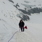
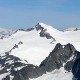
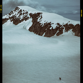

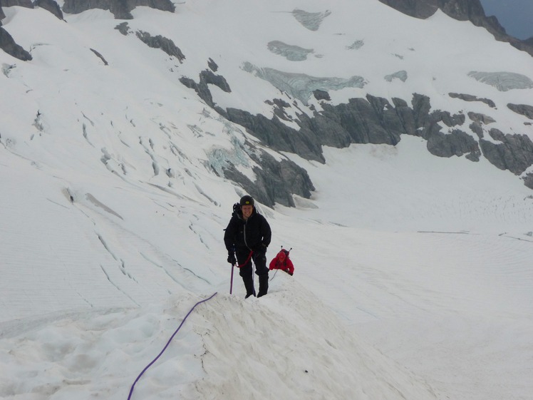
Classic knife edge ridge
Eldorado Peak
Eldorado Peak
Eldorado Peak

