– Lat/Long: 49.78° N 125.82° W
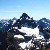
 Elkhorn
Weather Forecast, CanadaIssued: 4 pm Fri 03 Apr Local TimeUpdates in: hr min sUpdate imminent
Issued: 4 pm Fri 03 Apr Local Time
Updates in:
Update imminent hr min s

Issued: 4 pm Fri 03 Apr Local Time
Updates in:
Update imminent hr min s
Days 1–4 Weather SummaryA light covering of new snow mostly falling on Fri afternoon. Freeze-thaw conditions (max 3°C on Sun morning, min -5°C on Fri afternoon). Winds decreasing (fresh winds from the SW on Fri afternoon, calm by Sun morning). | Days 5–7 Weather SummaryMostly dry. Temperatures will be below freezing (max -1°C on Mon afternoon, min -9°C on Mon night). Winds decreasing (strong winds from the NW on Tue morning, light winds from the NNE by Tue night). | ||||||||||||||||
Fri 3 | Saturday 4 | Sunday 5 | Monday 6 | Tuesday 7 | Wednesday 8 | ||||||||||||
PM | night | AM | PM | night | AM | PM | night | AM | PM | night | AM | PM | night | AM | PM | night | |
mod. snow | light snow | clear | some clouds | some clouds | some clouds | some clouds | cloudy | some clouds | some clouds | clear | clear | some clouds | clear | clear | some clouds | clear | |
km/h | |||||||||||||||||
 |  |  |  |  |  | ||||||||||||
8 | 1 | — | — | — | — | — | — | — | — | — | — | — | — | — | — | — | |
— | — | — | — | — | — | — | — | — | — | — | — | — | — | — | — | — | |
max °C | -4 | -4 | -3 | -1 | 2 | 3 | 3 | 3 | 1 | -1 | -6 | -6 | -5 | -6 | -5 | -3 | -3 |
min °C | -5 | -4 | -4 | -2 | -1 | 2 | 3 | 2 | -1 | -3 | -9 | -7 | -6 | -6 | -6 | -4 | -3 |
-14 | -12 | -9 | -6 | -5 | 1 | 1 | -3 | -8 | -12 | -18 | -17 | -14 | -13 | -11 | -8 | -8 | |
1350 | 1400 | 1400 | 1900 | 2400 | 2650 | 2750 | 2600 | 2100 | 1800 | 550 | 1050 | 1300 | 900 | 1350 | 1800 | 1600 | |
Cloud base (m) | 750 | 750 | 800 | 1600 | 750 | 5550 | 6100 | 6450 | 4400 | 1750 | 750 | 2000 | 700 | 700 | 2200 | 1600 | |
— | — | 6:54 | — | — | 6:52 | — | — | 6:50 | — | — | 6:48 | — | — | 6:45 | — | — | |
7:57 | — | — | 7:59 | — | — | — | 8:00 | — | — | 8:01 | — | — | 8:02 | — | — | 8:05 | |
Loading...
Elkhorn Weather (Days 0-3):
The weather forecast for Elkhorn is: A light covering of new snow mostly falling on Fri afternoon. Freeze-thaw conditions (max 3°C on Sun morning, min -5°C on Fri afternoon). Winds decreasing (fresh winds from the SW on Fri afternoon, calm by Sun morning).
Elkhorn Weather (Days 3-6):
Mostly dry. Temperatures will be below freezing (max -1°C on Mon afternoon, min -9°C on Mon night). Winds decreasing (strong winds from the NW on Tue morning, light winds from the NNE by Tue night).
This table gives the weather forecast for Elkhorn at the specific elevation of 2195 m. Our advanced weather models allow us to provide distinct weather forecasts for several elevations of Elkhorn. To see the weather forecasts for the other elevations, use the tab navigation above the table. For a wider overview of the weather, consult the Weather Map of British-Columbia.
| Weather Station | Temp. | Weather | Wind | Gusts | Cloud / Visibility |
|---|---|---|---|---|---|
Campbell River Airport | |||||
SHIP326 | |||||
Sentry Shoal Buoy | |||||
Comox Millitary Base Airport | |||||
Cfb - Comox- BC | |||||
Comox Millitary Base Airport | |||||
Cfb - Comox- BC | |||||
Estevan Point Cs- BC | |||||
* NOTE: not all weather observatories update at the same frequency which is the reason why some locations may show data from stations that are further away than known closer ones.
Elkhorn Photos
View all
British Columbia Coast Ranges photos (61) |
Pacific Coast Ranges photos (1047) |
photos from mountains in Canada (452) |
all photos
 Upload new photo
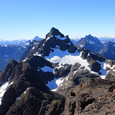
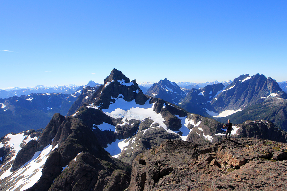
View from the summit of Kings Peak
Elkhorn