
– Lat/Long: 50.66° N 115.03° W
 Elpoca Mountain
Weather Forecast, CanadaIssued: 11 pm Mon 14 Apr Local TimeUpdates in: hr min sUpdate imminent
Elpoca Mountain Weather Forecast, Canada
Issued: 11 pm Mon 14 Apr Local Time
Updates in:
Update imminent hr min s

Issued: 11 pm Mon 14 Apr Local Time
Updates in:
Update imminent hr min s
Days 1–4 Weather SummaryA moderate fall of snow, heaviest on Wed morning. Temperatures will be below freezing (max -2°C on Mon night, min -16°C on Wed night). Winds decreasing (strong winds from the W on Mon night, light winds from the NW by Thu afternoon). | Days 5–7 Weather SummaryA heavy fall of snow, heaviest during Sun afternoon. Freeze-thaw conditions (max 2°C on Fri night, min -11°C on Sun afternoon). Winds decreasing (fresh winds from the WSW on Sat morning, calm by Sun morning). | ||||||||||||||||||
Tuesday 15 | Wednesday 16 | Thursday 17 | Friday 18 | Saturday 19 | Sunday 20 | ||||||||||||||
night | AM | PM | night | AM | PM | night | AM | PM | night | AM | PM | night | AM | PM | night | AM | PM | night | |
some clouds | some clouds | clear | snow shwrs | mod. snow | light snow | snow shwrs | clear | some clouds | clear | some clouds | clear | clear | some clouds | light snow | mod. snow | light snow | heavy snow | heavy snow | |
km/h | |||||||||||||||||||
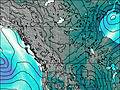 | 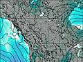 | 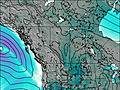 | 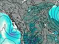 |  |  |  | |||||||||||||
— | — | — | 2.0 | 7 | 2.0 | 4 | — | — | — | — | — | — | — | 1.0 | 6 | 5 | 15 | 25 | |
— | — | — | — | — | — | — | — | — | — | — | — | — | — | — | — | — | — | — | |
max°C | -2 | -3 | -4 | -4 | -15 | -13 | -14 | -14 | -10 | -7 | -4 | -1 | 2 | -1 | -5 | -5 | -10 | -10 | -11 |
min°C | -3 | -4 | -4 | -11 | -15 | -14 | -16 | -16 | -12 | -10 | -5 | -4 | 0 | -3 | -5 | -9 | -10 | -11 | -12 |
-12 | -8 | -9 | -17 | -26 | -23 | -26 | -24 | -17 | -16 | -11 | -8 | -5 | -8 | -10 | -14 | -14 | -17 | -20 | |
1700 | 2300 | 2600 | 1800 | 1000 | 1300 | 900 | 900 | 1700 | 900 | 1850 | 2550 | 3300 | 2850 | 2400 | 1900 | 1650 | 1750 | 1300 | |
Cloud base (m) | 2250 | 2250 | 2750 | 2500 | 2250 | 2250 | 2250 | 2200 | 3100 | 3000 | 2200 | 4650 | 2250 | 2250 | 2650 | 2250 | 2250 | 2250 | 2250 |
— | 6:46 | — | — | 6:43 | — | — | 6:41 | — | — | 6:39 | — | — | 6:37 | — | — | 6:35 | — | — | |
— | — | 8:34 | — | — | 8:36 | — | — | 8:37 | — | — | 8:38 | — | — | 8:40 | — | — | 8:42 | — | |
Loading...
Elpoca Mountain Weather (Days 0-3):
The weather forecast for Elpoca Mountain is: A moderate fall of snow, heaviest on Wed morning. Temperatures will be below freezing (max -2°C on Mon night, min -16°C on Wed night). Winds decreasing (strong winds from the W on Mon night, light winds from the NW by Thu afternoon).
Elpoca Mountain Weather (Days 3-6):
A heavy fall of snow, heaviest during Sun afternoon. Freeze-thaw conditions (max 2°C on Fri night, min -11°C on Sun afternoon). Winds decreasing (fresh winds from the WSW on Sat morning, calm by Sun morning).
This table gives the weather forecast for Elpoca Mountain at the specific elevation of 3036 m. Our advanced weather models allow us to provide distinct weather forecasts for several elevations of Elpoca Mountain. To see the weather forecasts for the other elevations, use the tab navigation above the table. For a wider overview of the weather, consult the Weather Map of Alberta.
| Weather Station | Temp. | Weather | Wind | Gusts | Cloud / Visibility |
|---|---|---|---|---|---|
Nakiska Ridgetop- Alta | |||||
BowValley-Alta | |||||
Black Diamond- Alta | |||||
Swansea Mtn | |||||
Banff Airport |
* NOTE: not all weather observatories update at the same frequency which is the reason why some locations may show data from stations that are further away than known closer ones.

