– Lat/Long: 43.37° N 121.07° W
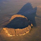
 Fort Rock
Weather Forecast, United StatesIssued: 4 pm Sun 30 Mar Local TimeUpdates in: hr min sUpdate imminent
Fort Rock Weather Forecast, United States
Issued: 4 pm Sun 30 Mar Local Time
Updates in:
Update imminent hr min s

Issued: 4 pm Sun 30 Mar Local Time
Updates in:
Update imminent hr min s
Days 1–4 Weather SummaryLight rain (total 5mm) at first, then becoming colder with a dusting of snow on Sun night. Freeze-thaw conditions (max 6°C on Sun afternoon, min -3°C on Mon night). Winds decreasing (strong winds from the S on Sun afternoon, light winds from the SW by Mon night). | Days 5–7 Weather SummaryMostly dry. Freeze-thaw conditions (max 9°C on Fri afternoon, min -2°C on Wed night). Wind will be generally light. | Days 8–10 Weather SummaryMostly dry. Very mild (max 18°C on Mon afternoon, min 7°C on Sat night). Wind will be generally light. | Days 11–13 Weather SummaryMostly dry. Warm (max 23°C on Fri afternoon, min 10°C on Tue night). Winds increasing (calm on Wed night, fresh winds from the SSW by Fri afternoon). | |||||||||||||||||||||||||||||||||
Sun 30 | Monday 31 | Tuesday 1 | Wednesday 2 | Thursday 3 | Friday 4 | Saturday 5 | Sunday 6 | Monday 7 | Tuesday 8 | Wednesday 9 | Thursday 10 | Fri 11 | ||||||||||||||||||||||||
PM | night | AM | PM | night | AM | PM | night | AM | PM | night | AM | PM | night | AM | PM | night | AM | PM | night | AM | PM | night | AM | PM | night | AM | PM | night | AM | PM | night | AM | PM | night | AM | |
rain shwrs | snow shwrs | some clouds | light rain | cloudy | light snow | light rain | some clouds | some clouds | light rain | some clouds | clear | light rain | clear | clear | clear | some clouds | clear | clear | clear | clear | clear | clear | clear | clear | clear | clear | clear | clear | clear | clear | clear | clear | clear | clear | clear | |
km/h | ||||||||||||||||||||||||||||||||||||
 |  |  |  |  |  |  |  |  |  |  |  |  | ||||||||||||||||||||||||
— | 2.0 | — | — | — | 1.0 | — | — | — | — | — | — | — | — | — | — | — | — | — | — | — | — | — | — | — | — | — | — | — | — | — | — | — | — | — | — | |
1.6 | 2 | — | 0.7 | — | — | 0.5 | — | — | 0.1 | — | — | 0.1 | — | — | — | — | — | — | — | — | — | — | — | — | — | — | — | — | — | — | — | — | — | — | — | |
max°C | 6 | 4 | 1 | 3 | -1 | 1 | 3 | 0 | 1 | 3 | 0 | 2 | 6 | 5 | 5 | 9 | 8 | 8 | 12 | 11 | 10 | 16 | 15 | 13 | 18 | 16 | 13 | 18 | 16 | 14 | 19 | 17 | 14 | 20 | 20 | 18 |
min°C | 5 | -1 | -1 | 2 | -3 | -2 | 1 | -3 | -2 | 3 | -2 | -1 | 4 | 1 | 1 | 7 | 4 | 4 | 11 | 7 | 7 | 14 | 10 | 9 | 16 | 9 | 9 | 17 | 10 | 10 | 18 | 11 | 10 | 18 | 14 | 14 |
-1 | -5 | -7 | -3 | -6 | -5 | -6 | -8 | -8 | -1 | -5 | -1 | 3 | -2 | -1 | 5 | 2 | 2 | 9 | 7 | 6 | 13 | 10 | 9 | 16 | 8 | 9 | 17 | 10 | 10 | 18 | 10 | 10 | 18 | 14 | 14 | |
2200 | 1500 | 1500 | 1650 | 1100 | 1500 | 1600 | 1100 | 1500 | 1750 | 1150 | 1650 | 2050 | 1650 | 2050 | 2400 | 2150 | 2500 | 2750 | 3400 | 3500 | 3600 | 3500 | 3250 | 3350 | 3150 | 2950 | 3350 | 3300 | 3550 | 3600 | 3650 | 3850 | 3850 | 3850 | 3850 | |
Cloud base (m) | 1650 | 1450 | 1550 | 2550 | 1400 | 1450 | 2200 | 2150 | 1750 | 2500 | 1550 | 1600 | 2400 | 2000 | 2850 | 6850 | 8900 | 9250 | 9500 | 9250 | ||||||||||||||||
— | — | 6:48 | — | — | 6:46 | — | — | 6:43 | — | — | 6:43 | — | — | 6:41 | — | — | 6:39 | — | — | 6:37 | — | — | 6:35 | — | — | 6:33 | — | — | 6:31 | — | — | 6:30 | — | — | 6:28 | |
7:28 | — | — | 7:29 | — | — | 7:30 | — | — | 7:30 | — | — | 7:31 | — | — | 7:34 | — | — | 7:35 | — | — | 7:36 | — | — | 7:37 | — | — | 7:37 | — | — | 7:38 | — | — | 7:40 | — | — | |
Fort Rock Weather (Days 0-3):
The weather forecast for Fort Rock is: Light rain (total 5mm) at first, then becoming colder with a dusting of snow on Sun night. Freeze-thaw conditions (max 6°C on Sun afternoon, min -3°C on Mon night). Winds decreasing (strong winds from the S on Sun afternoon, light winds from the SW by Mon night).
Fort Rock Weather (Days 3-6):
Mostly dry. Freeze-thaw conditions (max 9°C on Fri afternoon, min -2°C on Wed night). Wind will be generally light.
Fort Rock Weather (Days 6-9):
Mostly dry. Very mild (max 18°C on Mon afternoon, min 7°C on Sat night). Wind will be generally light.
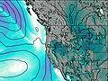
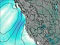
This table gives the weather forecast for Fort Rock at the specific elevation of 1432 m. Our advanced weather models allow us to provide distinct weather forecasts for several elevations of Fort Rock. To see the weather forecasts for the other elevations, use the tab navigation above the table. For a wider overview of the weather, consult the Weather Map of Oregon.
| Weather Station | Temp. | Weather | Wind | Gusts | Cloud / Visibility |
|---|---|---|---|---|---|
Sunriver Airport (Oregon) | |||||
* NOTE: not all weather observatories update at the same frequency which is the reason why some locations may show data from stations that are further away than known closer ones.