– Lat/Long: 35.28° N 23.93° E
 Gingilos
Weather Forecast, GreeceIssued: 8 am Sat 19 Apr Local TimeUpdates in: hr min sUpdate imminent
Gingilos Weather Forecast, Greece
Issued: 8 am Sat 19 Apr Local Time
Updates in:
Update imminent hr min s

Issued: 8 am Sat 19 Apr Local Time
Updates in:
Update imminent hr min s
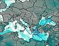
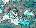
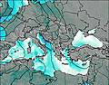
Days 1–3 Weather SummaryMostly dry. Very mild (max 12°C on Mon night, min 10°C on Sat morning). Mainly fresh winds. | Days 4–6 Weather SummaryLight rain (total 4mm), mostly falling on Thu afternoon. Very mild (max 11°C on Tue morning, min 4°C on Thu morning). Winds decreasing (fresh winds from the SSW on Tue afternoon, light winds from the NNW by Wed morning). | |||||||||||||||||
Saturday 19 | Sunday 20 | Monday 21 | Tuesday 22 | Wednesday 23 | Thursday 24 | |||||||||||||
AM | PM | night | AM | PM | night | AM | PM | night | AM | PM | night | AM | PM | night | AM | PM | night | |
some clouds | clear | clear | some clouds | clear | some clouds | some clouds | clear | some clouds | some clouds | rain shwrs | rain shwrs | clear | clear | clear | rain shwrs | rain shwrs | rain shwrs | |
km/h | ||||||||||||||||||
 |  |  |  |  |  | |||||||||||||
— | — | — | — | — | — | — | — | — | — | — | — | — | — | — | — | — | — | |
— | — | — | — | — | — | — | — | — | — | 0.1 | 0.3 | — | — | — | 0.5 | 3 | 0.1 | |
max°C | 11 | 10 | 10 | 10 | 10 | 11 | 11 | 10 | 12 | 11 | 9 | 7 | 7 | 7 | 6 | 4 | 5 | 6 |
min°C | 10 | 10 | 10 | 10 | 10 | 10 | 10 | 10 | 10 | 10 | 8 | 7 | 7 | 7 | 5 | 4 | 5 | 5 |
7 | 7 | 7 | 8 | 8 | 8 | 8 | 8 | 9 | 6 | 4 | 3 | 4 | 5 | 1 | 0 | 2 | 1 | |
3900 | 3850 | 3800 | 3750 | 3750 | 3700 | 3600 | 3650 | 3600 | 3550 | 3500 | 3650 | 3450 | 3350 | 3050 | 2700 | 2700 | 3050 | |
Cloud base (m) | 8500 | 7150 | 8450 | 7700 | 8450 | 6300 | 4850 | 3650 | 3900 | 100 | 4750 | 2800 | 1850 | |||||
6:47 | — | — | 6:46 | — | — | 6:45 | — | — | 6:43 | — | — | 6:41 | — | — | 6:41 | — | — | |
— | 7:59 | — | — | 8:00 | — | — | 8:00 | — | — | 8:01 | — | — | 8:02 | — | — | 8:02 | — | |
Loading...
Gingilos Weather (Days 0-3):
The weather forecast for Gingilos is: Mostly dry. Very mild (max 12°C on Mon night, min 10°C on Sat morning). Mainly fresh winds.
Gingilos Weather (Days 3-6):
Light rain (total 4mm), mostly falling on Thu afternoon. Very mild (max 11°C on Tue morning, min 4°C on Thu morning). Winds decreasing (fresh winds from the SSW on Tue afternoon, light winds from the NNW by Wed morning).
This table gives the weather forecast for Gingilos at the specific elevation of 2080 m. Our advanced weather models allow us to provide distinct weather forecasts for several elevations of Gingilos. To see the weather forecasts for the other elevations, use the tab navigation above the table. For a wider overview of the weather, consult the Weather Map of Greece.
| Weather Station | Temp. | Weather | Wind | Gusts | Cloud / Visibility |
|---|---|---|---|---|---|
Soud / hania Airport | |||||
Souda (Airport) | |||||
ASCATB23E36N | |||||
Kythira |
* NOTE: not all weather observatories update at the same frequency which is the reason why some locations may show data from stations that are further away than known closer ones.
Gingilos Photos
View all
Greek Islands photos (56) |
Balkan Peninsula photos (1021) |
photos from mountains in Greece (662) |
all photos
 Upload new photo
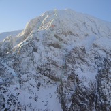
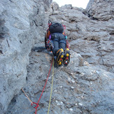
winter gigilos with "hard ice on the rocks" M5+ WI4+ 780m
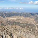
The view from Gigilos.
"το αλφαβητάρι του αιωνόβιου" M4+ WI3 1000m ("perennials ABC")

