– Lat/Long: 48.11° N 121.11° W
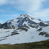
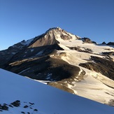
 Glacier Peak
Weather Forecast, United StatesIssued: 10 am Sun 13 Apr Local TimeUpdates in: hr min sUpdate imminent
Glacier Peak Weather Forecast, United States
Issued: 10 am Sun 13 Apr Local Time
Updates in:
Update imminent hr min s

Issued: 10 am Sun 13 Apr Local Time
Updates in:
Update imminent hr min s
Days 1–3 Weather SummaryMostly dry. Very mild (max 16°C on Mon afternoon, min 4°C on Sun morning). Wind will be generally light. | Days 4–6 Weather SummaryLight rain (total 4mm), mostly falling on Wed afternoon. Very mild (max 17°C on Fri afternoon, min 4°C on Wed night). Wind will be generally light. | Days 7–9 Weather SummaryLight rain (total 4mm), mostly falling on Mon afternoon. Very mild (max 16°C on Sat afternoon, min 2°C on Sun night). Wind will be generally light. | Days 10–12 Weather SummaryLight rain (total 5mm), mostly falling on Tue afternoon. Mild temperatures (max 8°C on Wed afternoon, min 3°C on Tue morning). Wind will be generally light. | |||||||||||||||||||||||||||||||||
Sunday 13 | Monday 14 | Tuesday 15 | Wednesday 16 | Thursday 17 | Friday 18 | Saturday 19 | Sunday 20 | Monday 21 | Tuesday 22 | Wednesday 23 | Thursday 24 | |||||||||||||||||||||||||
AM | PM | night | AM | PM | night | AM | PM | night | AM | PM | night | AM | PM | night | AM | PM | night | AM | PM | night | AM | PM | night | AM | PM | night | AM | PM | night | AM | PM | night | AM | PM | night | |
clear | some clouds | some clouds | some clouds | some clouds | clear | some clouds | clear | clear | rain shwrs | rain shwrs | clear | clear | cloudy | clear | clear | clear | clear | some clouds | some clouds | some clouds | rain shwrs | rain shwrs | rain shwrs | rain shwrs | light rain | rain shwrs | rain shwrs | light rain | rain shwrs | rain shwrs | rain shwrs | rain shwrs | some clouds | rain shwrs | clear | |
km/h | ||||||||||||||||||||||||||||||||||||
 |  |  |  |  |  |  |  |  |  |  |  | |||||||||||||||||||||||||
— | — | — | — | — | — | — | — | — | — | — | — | — | — | — | — | — | — | — | — | — | — | — | — | — | — | — | — | — | — | — | — | — | — | — | — | |
— | — | — | — | — | — | — | — | — | 0.4 | 3 | — | — | — | — | — | — | — | — | — | — | 0.1 | 0.2 | 1.3 | 0.7 | 1.1 | 1.1 | 1.8 | 2 | 0.5 | 0.2 | 0.3 | 0.1 | — | 0.1 | — | |
max°C | 8 | 11 | 8 | 12 | 16 | 12 | 13 | 15 | 10 | 8 | 9 | 6 | 9 | 12 | 9 | 14 | 17 | 12 | 15 | 16 | 11 | 7 | 8 | 5 | 6 | 7 | 4 | 5 | 6 | 4 | 6 | 8 | 6 | 7 | 8 | 6 |
min°C | 4 | 11 | 6 | 9 | 15 | 8 | 10 | 15 | 5 | 7 | 7 | 4 | 5 | 11 | 6 | 9 | 17 | 8 | 11 | 16 | 7 | 6 | 8 | 2 | 3 | 7 | 2 | 3 | 5 | 3 | 4 | 8 | 3 | 4 | 8 | 4 |
4 | 11 | 5 | 8 | 15 | 8 | 10 | 15 | 4 | 6 | 5 | 3 | 4 | 10 | 5 | 9 | 17 | 8 | 11 | 16 | 6 | 5 | 6 | 0 | 1 | 6 | 0 | 1 | 3 | 1 | 3 | 7 | 2 | 3 | 7 | 4 | |
1650 | 2200 | 2550 | 2650 | 2800 | 2500 | 2500 | 2400 | 1650 | 1650 | 1700 | 1250 | 1700 | 2050 | 1800 | 2700 | 3150 | 3400 | 2900 | 2600 | 1950 | 1500 | 1600 | 900 | 1350 | 1500 | 800 | 1250 | 1300 | 1050 | 1400 | 1650 | 1150 | 1500 | 1700 | 1250 | |
Cloud base (m) | 8850 | 5150 | 1750 | 2000 | 2600 | 2250 | 1550 | 1600 | 1800 | 2650 | 3200 | 6900 | 6400 | 8800 | 3400 | 2900 | 1600 | 1600 | 1700 | 1550 | 1700 | 1900 | 2300 | 1650 | 1800 | 1550 | 1600 | 1850 | 1550 | 1600 | 1950 | 1550 | ||||
6:18 | — | — | 6:16 | — | — | 6:15 | — | — | 6:13 | — | — | 6:11 | — | — | 6:09 | — | — | 6:07 | — | — | 6:05 | — | — | 6:03 | — | — | 6:01 | — | — | 6:00 | — | — | 5:58 | — | — | |
— | 7:51 | — | — | 7:52 | — | — | 7:53 | — | — | 7:55 | — | — | 7:57 | — | — | 7:58 | — | — | — | 8:00 | — | — | 8:00 | — | — | 8:02 | — | — | 8:04 | — | — | 8:06 | — | — | 8:07 | |
Glacier Peak Weather (Days 0-3):
The weather forecast for Glacier Peak is: Mostly dry. Very mild (max 16°C on Mon afternoon, min 4°C on Sun morning). Wind will be generally light.
Glacier Peak Weather (Days 3-6):
Light rain (total 4mm), mostly falling on Wed afternoon. Very mild (max 17°C on Fri afternoon, min 4°C on Wed night). Wind will be generally light.
Glacier Peak Weather (Days 6-9):
Light rain (total 4mm), mostly falling on Mon afternoon. Very mild (max 16°C on Sat afternoon, min 2°C on Sun night). Wind will be generally light.
This table gives the weather forecast for Glacier Peak at the specific elevation of 500 m. Our advanced weather models allow us to provide distinct weather forecasts for several elevations of Glacier Peak. To see the weather forecasts for the other elevations, use the tab navigation above the table. For a wider overview of the weather, consult the Weather Map of Washington.
| Weather Station | Temp. | Weather | Wind | Gusts | Cloud / Visibility |
|---|---|---|---|---|---|
Seattl / oeing Airport |
* NOTE: not all weather observatories update at the same frequency which is the reason why some locations may show data from stations that are further away than known closer ones.
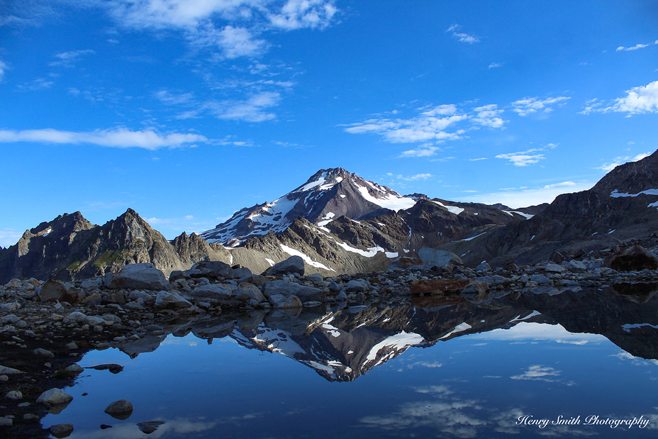
Glacier Peak Photos
View all
Cascade Range photos (426) |
Pacific Coast Ranges photos (999) |
photos from mountains in United States (2882) |
all photos
 Upload new photo
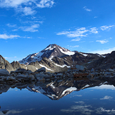
Reflection
Glacier Peak
Glacier Peak

