
– Lat/Long: 27.96° N 86.68° E
 Gokyo Ri
Weather Forecast, NepalIssued: 10 am Sun 30 Mar Local TimeUpdates in: hr min sUpdate imminent
Gokyo Ri Weather Forecast, Nepal
Issued: 10 am Sun 30 Mar Local Time
Updates in:
Update imminent hr min s

Issued: 10 am Sun 30 Mar Local Time
Updates in:
Update imminent hr min s
Days 1–3 Weather SummaryMostly dry. Freeze-thaw conditions (max 1°C on Sun morning, min -5°C on Mon night). Mainly fresh winds. | Days 4–6 Weather SummaryA light covering of new snow mostly falling on Fri afternoon. Temperatures will be below freezing (max -1°C on Wed morning, min -10°C on Fri night). Winds decreasing (fresh winds from the SW on Fri morning, light winds from the SW by Fri night). | Days 7–9 Weather SummaryA dusting of new snow. Freeze-thaw conditions (max 1°C on Mon morning, min -7°C on Sat morning). Wind will be generally light. | Days 10–12 Weather SummaryA dusting of new snow. Freeze-thaw conditions (max 2°C on Thu morning, min -3°C on Thu night). Wind will be generally light. | |||||||||||||||||||||||||||||||||
Sunday 30 | Monday 31 | Tuesday 1 | Wednesday 2 | Thursday 3 | Friday 4 | Saturday 5 | Sunday 6 | Monday 7 | Tuesday 8 | Wednesday 9 | Thursday 10 | |||||||||||||||||||||||||
AM | PM | night | AM | PM | night | AM | PM | night | AM | PM | night | AM | PM | night | AM | PM | night | AM | PM | night | AM | PM | night | AM | PM | night | AM | PM | night | AM | PM | night | AM | PM | night | |
clear | some clouds | clear | clear | clear | clear | clear | clear | clear | some clouds | some clouds | some clouds | some clouds | cloudy | some clouds | light snow | light snow | snow shwrs | some clouds | clear | clear | clear | some clouds | clear | clear | snow shwrs | clear | clear | snow shwrs | some clouds | some clouds | snow shwrs | some clouds | some clouds | snow shwrs | some clouds | |
km/h | ||||||||||||||||||||||||||||||||||||
 |  |  |  |  |  |  |  |  |  |  | ||||||||||||||||||||||||||
— | — | — | — | — | — | — | — | — | — | — | — | — | — | — | 2.0 | 2.0 | 1.0 | — | — | — | — | — | — | — | 2.0 | — | — | 1.0 | — | — | 1.0 | — | — | 1.0 | — | |
— | — | — | — | — | — | — | — | — | — | — | — | — | — | — | — | — | — | — | — | — | — | — | — | — | — | — | — | — | — | — | — | — | — | — | — | |
max°C | 1 | 1 | -3 | 0 | 0 | -4 | -1 | 0 | -4 | -1 | -1 | -5 | -1 | -2 | -5 | -4 | -4 | -6 | -5 | -4 | -5 | -2 | 0 | -4 | 1 | 1 | -3 | 1 | 1 | -1 | 0 | 1 | -1 | 2 | 1 | -1 |
min°C | 0 | -2 | -4 | -1 | -3 | -5 | -2 | -3 | -5 | -2 | -3 | -5 | -2 | -3 | -6 | -5 | -5 | -10 | -7 | -5 | -7 | -3 | -2 | -4 | 0 | -1 | -4 | 0 | 0 | -2 | -1 | -1 | -2 | 1 | 1 | -3 |
-7 | -9 | -11 | -8 | -10 | -11 | -9 | -10 | -12 | -9 | -9 | -11 | -8 | -9 | -12 | -13 | -12 | -14 | -7 | -11 | -14 | -10 | -6 | -10 | -2 | -1 | -7 | 0 | 0 | -2 | -3 | -3 | -5 | 1 | -2 | -6 | |
4600 | 4150 | 3800 | 4500 | 4050 | 3650 | 4450 | 4000 | 3650 | 4400 | 4000 | 3700 | 4350 | 4100 | 3650 | 3900 | 3850 | 2850 | 3850 | 3650 | 3350 | 4250 | 4200 | 3850 | 4650 | 4300 | 3900 | 4600 | 4500 | 4150 | 4500 | 4400 | 4250 | 4750 | 4600 | 4100 | |
Cloud base (m) | 7150 | 6700 | 6250 | 7250 | 6900 | 7100 | 7050 | 6150 | 6700 | 5850 | 6200 | 5850 | 5950 | 8400 | 6700 | 6300 | 5900 | 6200 | 6150 | 6350 | 6400 | 6600 | ||||||||||||||
5:50 | — | — | 5:50 | — | — | 5:48 | — | — | 5:47 | — | — | 5:46 | — | — | 5:45 | — | — | 5:43 | — | — | 5:43 | — | — | 5:41 | — | — | 5:41 | — | — | 5:39 | — | — | 5:39 | — | — | |
— | 6:14 | — | — | 6:15 | — | — | 6:15 | — | — | 6:15 | — | — | 6:15 | — | — | 6:16 | — | — | 6:16 | — | — | 6:17 | — | — | 6:17 | — | — | 6:19 | — | — | 6:20 | — | — | 6:20 | — | |
Gokyo Ri Weather (Days 0-3):
The weather forecast for Gokyo Ri is: Mostly dry. Freeze-thaw conditions (max 1°C on Sun morning, min -5°C on Mon night). Mainly fresh winds.
Gokyo Ri Weather (Days 3-6):
A light covering of new snow mostly falling on Fri afternoon. Temperatures will be below freezing (max -1°C on Wed morning, min -10°C on Fri night). Winds decreasing (fresh winds from the SW on Fri morning, light winds from the SW by Fri night).
Gokyo Ri Weather (Days 6-9):
A dusting of new snow. Freeze-thaw conditions (max 1°C on Mon morning, min -7°C on Sat morning). Wind will be generally light.
This table gives the weather forecast for Gokyo Ri at the specific elevation of 4500 m. Our advanced weather models allow us to provide distinct weather forecasts for several elevations of Gokyo Ri. To see the weather forecasts for the other elevations, use the tab navigation above the table. For a wider overview of the weather, consult the Weather Map of Nepal.
| Weather Station | Temp. | Weather | Wind | Gusts | Cloud / Visibility |
|---|---|---|---|---|---|
Tingri | |||||
Pakyong Airport- Pakyong | |||||
* NOTE: not all weather observatories update at the same frequency which is the reason why some locations may show data from stations that are further away than known closer ones.
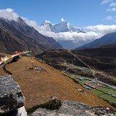
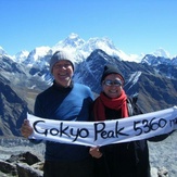
Gokyo Ri Photos
View all
Central Nepal Himalaya photos (107) |
Greater Himalaya photos (215) |
photos from mountains in Nepal (179) |
all photos
 Upload new photo
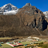
Machermo en route to Gokyo Ri
Machermo en route to Gokyo

