
– Lat/Long: 33.11° S 19.15° E
 Groot-Winterhoek Peak
Weather Forecast, South AfricaIssued: 7 pm Mon 31 Mar Local TimeUpdates in: hr min sUpdate imminent
Groot-Winterhoek Peak Weather Forecast, South Africa
Issued: 7 pm Mon 31 Mar Local Time
Updates in:
Update imminent hr min s

Issued: 7 pm Mon 31 Mar Local Time
Updates in:
Update imminent hr min s
Days 1–4 Weather SummaryMostly dry. Very mild (max 16°C on Thu afternoon, min 9°C on Tue morning). Wind will be generally light. | Days 5–7 Weather SummarySome drizzle, heaviest during Sat night. Very mild (max 17°C on Sun afternoon, min 13°C on Thu night). Winds increasing (calm on Fri morning, strong winds from the ENE by Sat night). | Days 8–10 Weather SummaryHeavy rain (total 34mm), heaviest during Mon night. Very mild (max 17°C on Sun night, min 10°C on Tue afternoon). Winds decreasing (strong winds from the ENE on Sun night, calm by Wed afternoon). | Days 11–13 Weather SummarySome drizzle, heaviest during Wed night. Very mild (max 13°C on Fri night, min 9°C on Wed night). Wind will be generally light. | |||||||||||||||||||||||||||||||||
Tuesday 1 | Wednesday 2 | Thursday 3 | Friday 4 | Saturday 5 | Sunday 6 | Monday 7 | Tuesday 8 | Wednesday 9 | Thursday 10 | Friday 11 | Sat 12 | |||||||||||||||||||||||||
night | AM | PM | night | AM | PM | night | AM | PM | night | AM | PM | night | AM | PM | night | AM | PM | night | AM | PM | night | AM | PM | night | AM | PM | night | AM | PM | night | AM | PM | night | AM | PM | |
clear | clear | clear | clear | clear | clear | clear | clear | clear | rain shwrs | rain shwrs | some clouds | clear | some clouds | clear | rain shwrs | rain shwrs | clear | some clouds | rain shwrs | light rain | heavy rain | mod. rain | risk tstorm | rain shwrs | light rain | rain shwrs | rain shwrs | rain shwrs | rain shwrs | some clouds | clear | some clouds | clear | clear | clear | |
km/h | ||||||||||||||||||||||||||||||||||||
 |  |  |  |  |  |  |  |  |  |  |  |  | ||||||||||||||||||||||||
— | — | — | — | — | — | — | — | — | — | — | — | — | — | — | — | — | — | — | — | — | — | — | — | — | — | — | — | — | — | — | — | — | — | — | — | |
— | — | — | — | — | — | — | — | — | 0.3 | 0.3 | — | — | — | — | 0.9 | 0.1 | — | — | 0.8 | 0.7 | 19 | 7 | 3 | 3 | 0.5 | 0.4 | 0.6 | 0.5 | 0.4 | — | — | — | — | — | — | |
max°C | 12 | 9 | 11 | 11 | 10 | 13 | 14 | 15 | 16 | 15 | 13 | 15 | 14 | 14 | 16 | 16 | 16 | 17 | 17 | 16 | 17 | 15 | 11 | 11 | 11 | 10 | 11 | 10 | 9 | 10 | 11 | 11 | 12 | 13 | 12 | 13 |
min°C | 10 | 9 | 10 | 10 | 10 | 12 | 12 | 14 | 16 | 13 | 13 | 14 | 13 | 13 | 15 | 14 | 15 | 17 | 16 | 16 | 16 | 11 | 11 | 10 | 10 | 10 | 10 | 9 | 9 | 9 | 10 | 11 | 12 | 12 | 12 | 13 |
9 | 8 | 9 | 10 | 10 | 12 | 11 | 13 | 16 | 13 | 13 | 14 | 12 | 11 | 14 | 12 | 13 | 17 | 15 | 15 | 15 | 8 | 9 | 10 | 9 | 9 | 10 | 9 | 9 | 8 | 9 | 11 | 12 | 12 | 12 | 12 | |
3950 | 3900 | 3950 | 3950 | 3950 | 4100 | 4100 | 4000 | 4050 | 3950 | 3800 | 3900 | 3900 | 3850 | 4000 | 4100 | 4200 | 4250 | 4350 | 4350 | 4200 | 4150 | 4050 | 4050 | 4400 | 4250 | 4100 | 3850 | 3750 | 4050 | 4150 | 4250 | 4300 | 4200 | 4300 | 4300 | |
Cloud base (m) | 600 | 800 | 3650 | 9600 | 9600 | 3050 | 4500 | 5600 | 5250 | 3150 | 1800 | 1800 | 800 | 750 | 800 | 850 | 750 | 700 | 900 | 9450 | 2250 | |||||||||||||||
— | 6:54 | — | — | 6:54 | — | — | 6:56 | — | — | 6:56 | — | — | 6:58 | — | — | 6:58 | — | — | 6:58 | — | — | 7:00 | — | — | 7:00 | — | — | 7:01 | — | — | 7:01 | — | — | 7:03 | — | |
— | — | 6:37 | — | — | 6:37 | — | — | 6:36 | — | — | 6:35 | — | — | 6:32 | — | — | 6:31 | — | — | 6:30 | — | — | 6:29 | — | — | 6:28 | — | — | 6:27 | — | — | 6:25 | — | — | 6:23 | |
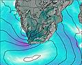
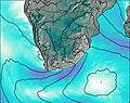
Groot-Winterhoek Peak Weather (Days 0-3):
The weather forecast for Groot-Winterhoek Peak is: Mostly dry. Very mild (max 16°C on Thu afternoon, min 9°C on Tue morning). Wind will be generally light.
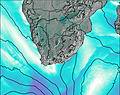
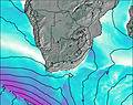
Groot-Winterhoek Peak Weather (Days 3-6):
Some drizzle, heaviest during Sat night. Very mild (max 17°C on Sun afternoon, min 13°C on Thu night). Winds increasing (calm on Fri morning, strong winds from the ENE by Sat night).
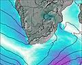
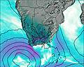
Groot-Winterhoek Peak Weather (Days 6-9):
Heavy rain (total 34mm), heaviest during Mon night. Very mild (max 17°C on Sun night, min 10°C on Tue afternoon). Winds decreasing (strong winds from the ENE on Sun night, calm by Wed afternoon).
This table gives the weather forecast for Groot-Winterhoek Peak at the specific elevation of 2078 m. Our advanced weather models allow us to provide distinct weather forecasts for several elevations of Groot-Winterhoek Peak. To see the weather forecasts for the other elevations, use the tab navigation above the table. For a wider overview of the weather, consult the Weather Map of South Africa.

