
– Lat/Long: 47.84° N 8.02° E
 Herzogenhorn
Weather Forecast, GermanyIssued: 1 pm Wed 16 Apr Local TimeUpdates in: hr min sUpdate imminent
Herzogenhorn Weather Forecast, Germany
Issued: 1 pm Wed 16 Apr Local Time
Updates in:
Update imminent hr min s

Issued: 1 pm Wed 16 Apr Local Time
Updates in:
Update imminent hr min s
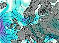
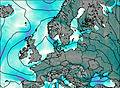
Days 1–4 Weather SummaryMild at first with light rain (total 2mm) on Wed afternoon followed by colder weather and light fall of snow, heaviest on Thu night. Freeze-thaw conditions (max 7°C on Sat morning, min -2°C on Fri morning). Winds decreasing (strong winds from the W on Fri morning, calm by Sat morning). | Days 5–7 Weather SummaryMild with moderate rain (total 12mm) on Sun night, Becoming colder with a light covering of snow, mostly falling on Sun night. Very mild (max 10°C on Sat afternoon, min 2°C on Sun night). Winds decreasing (near gales from the E on Sat night, calm by Mon afternoon). | ||||||||||||||||
Wed 16 | Thursday 17 | Friday 18 | Saturday 19 | Sunday 20 | Monday 21 | ||||||||||||
PM | night | AM | PM | night | AM | PM | night | AM | PM | night | AM | PM | night | AM | PM | night | |
light rain | light snow | cloudy | cloudy | light snow | light snow | cloudy | clear | some clouds | clear | some clouds | some clouds | rain shwrs | light snow | light rain | light rain | some clouds | |
km/h | |||||||||||||||||
 |  |  |  |  |  | ||||||||||||
— | 4 | — | — | 5 | 2.0 | — | — | — | — | — | — | — | 5 | — | — | — | |
2.0 | — | — | — | — | — | — | — | — | — | — | — | 1.0 | 8 | 3 | 0.5 | — | |
max°C | 4 | 2 | 1 | 2 | 1 | -1 | 1 | 6 | 7 | 10 | 9 | 7 | 7 | 6 | 2 | 3 | 4 |
min°C | 2 | 1 | 1 | 2 | -1 | -2 | -1 | 2 | 7 | 9 | 8 | 4 | 6 | 2 | 2 | 2 | 3 |
-4 | -4 | -5 | -2 | -9 | -10 | -8 | -3 | 5 | 9 | 3 | 0 | 5 | -1 | -2 | 2 | 2 | |
2100 | 1800 | 2000 | 1950 | 1400 | 1200 | 1550 | 2600 | 2600 | 2700 | 3000 | 2400 | 2350 | 2100 | 1800 | 2100 | 2150 | |
Cloud base (m) | 550 | 550 | 550 | 550 | 550 | 600 | 550 | 700 | 2150 | 1550 | 550 | 650 | 1550 | ||||
— | — | 6:35 | — | — | 6:33 | — | — | 6:31 | — | — | 6:30 | — | — | 6:28 | — | — | |
— | 8:17 | — | — | 8:19 | — | — | 8:21 | — | — | 8:22 | — | — | 8:23 | — | — | 8:24 | |
Loading...
Herzogenhorn Weather (Days 0-3):
The weather forecast for Herzogenhorn is: Mild at first with light rain (total 2mm) on Wed afternoon followed by colder weather and light fall of snow, heaviest on Thu night. Freeze-thaw conditions (max 7°C on Sat morning, min -2°C on Fri morning). Winds decreasing (strong winds from the W on Fri morning, calm by Sat morning).
Herzogenhorn Weather (Days 3-6):
Mild with moderate rain (total 12mm) on Sun night, Becoming colder with a light covering of snow, mostly falling on Sun night. Very mild (max 10°C on Sat afternoon, min 2°C on Sun night). Winds decreasing (near gales from the E on Sat night, calm by Mon afternoon).
This table gives the weather forecast for Herzogenhorn at the specific elevation of 1415 m. Our advanced weather models allow us to provide distinct weather forecasts for several elevations of Herzogenhorn. To see the weather forecasts for the other elevations, use the tab navigation above the table. For a wider overview of the weather, consult the Weather Map of Germany.

