– Lat/Long: 46.24° N 8.06° E
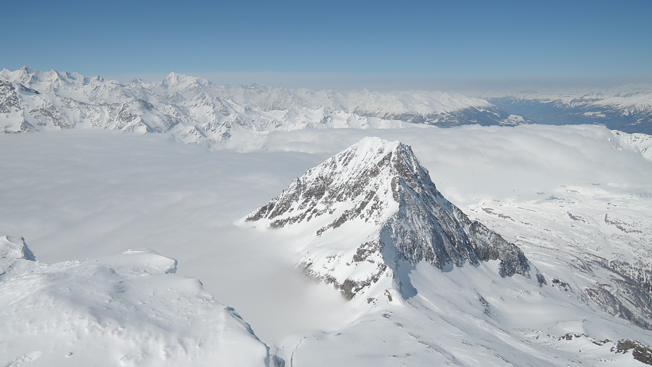
 Hübschhorn
Weather Forecast, SwitzerlandIssued: 7 pm Mon 31 Mar Local TimeUpdates in: hr min sUpdate imminent
Hübschhorn Weather Forecast, Switzerland
Issued: 7 pm Mon 31 Mar Local Time
Updates in:
Update imminent hr min s

Issued: 7 pm Mon 31 Mar Local Time
Updates in:
Update imminent hr min s
Days 1–4 Weather SummaryA moderate fall of snow, heaviest on Wed afternoon. Freeze-thaw conditions (max 3°C on Thu afternoon, min -7°C on Tue night). Wind will be generally light. | Days 5–7 Weather SummaryMostly dry. Mild temperatures (max 5°C on Sun afternoon, min 1°C on Thu night). Wind will be generally light. | ||||||||||||||||||
Tuesday 1 | Wednesday 2 | Thursday 3 | Friday 4 | Saturday 5 | Sunday 6 | ||||||||||||||
night | AM | PM | night | AM | PM | night | AM | PM | night | AM | PM | night | AM | PM | night | AM | PM | night | |
clear | clear | some clouds | cloudy | mod. snow | snow shwrs | clear | some clouds | clear | clear | clear | clear | clear | clear | some clouds | clear | clear | clear | some clouds | |
km/h | |||||||||||||||||||
 |  |  |  |  |  |  | |||||||||||||
— | — | — | — | 7 | 8 | — | — | — | — | — | — | — | — | — | — | — | — | — | |
— | — | — | — | — | — | — | — | — | — | — | — | — | — | — | — | — | — | — | |
max°C | -3 | -4 | -6 | -5 | -4 | -3 | -2 | 1 | 3 | 2 | 4 | 4 | 2 | 3 | 3 | 2 | 3 | 5 | 3 |
min°C | -3 | -5 | -6 | -7 | -4 | -4 | -3 | -1 | 2 | 1 | 2 | 4 | 1 | 1 | 3 | 1 | 1 | 4 | 0 |
-8 | -8 | -12 | -13 | -9 | -9 | -8 | -1 | 2 | 1 | 0 | 4 | -2 | -2 | 0 | -2 | -2 | 3 | 0 | |
1400 | 1850 | 1800 | 1700 | 1900 | 2050 | 1700 | 2750 | 2900 | 3050 | 3150 | 3000 | 2850 | 2850 | 2900 | 2750 | 2950 | 3050 | 2600 | |
Cloud base (m) | 2200 | 2750 | 2350 | 2200 | 2200 | 2200 | 2750 | 2400 | 7300 | 2450 | |||||||||
— | 7:07 | — | — | 7:05 | — | — | 7:03 | — | — | 7:03 | — | — | 7:01 | — | — | 6:58 | — | — | |
— | — | 7:54 | — | — | 7:55 | — | — | 7:58 | — | — | 7:59 | — | — | — | 8:00 | — | — | 8:01 | |
Hübschhorn Weather (Days 0-3):
The weather forecast for Hübschhorn is: A moderate fall of snow, heaviest on Wed afternoon. Freeze-thaw conditions (max 3°C on Thu afternoon, min -7°C on Tue night). Wind will be generally light.
Hübschhorn Weather (Days 3-6):
Mostly dry. Mild temperatures (max 5°C on Sun afternoon, min 1°C on Thu night). Wind will be generally light.
This table gives the weather forecast for Hübschhorn at the specific elevation of 2500 m. Our advanced weather models allow us to provide distinct weather forecasts for several elevations of Hübschhorn. To see the weather forecasts for the other elevations, use the tab navigation above the table. For a wider overview of the weather, consult the Weather Map of Switzerland.
Hübschhorn Photos
View all
Lepontine Alps photos (83) |
Alps photos (1455) |
photos from mountains in Switzerland (643) |
all photos
 Upload new photo
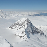
Hübshhorn winter shot
Hübschhorn

