
– Lat/Long: 52.12° N 120.05° W
 Jack's Jump
Weather Forecast, CanadaIssued: 10 pm Thu 24 Apr Local TimeUpdates in: hr min sUpdate imminent
Jack's Jump Weather Forecast, Canada
Issued: 10 pm Thu 24 Apr Local Time
Updates in:
Update imminent hr min s

Issued: 10 pm Thu 24 Apr Local Time
Updates in:
Update imminent hr min s
Days 1–4 Weather SummaryLight rain (total 2mm), mostly falling on Sun afternoon. Very mild (max 15°C on Fri afternoon, min 5°C on Thu night). Wind will be generally light. | Days 5–7 Weather SummaryLight rain (total 7mm), mostly falling on Mon afternoon. Very mild (max 16°C on Wed afternoon, min 4°C on Sun night). Wind will be generally light. | ||||||||||||||||||
Friday 25 | Saturday 26 | Sunday 27 | Monday 28 | Tuesday 29 | Wednesday 30 | ||||||||||||||
night | AM | PM | night | AM | PM | night | AM | PM | night | AM | PM | night | AM | PM | night | AM | PM | night | |
clear | clear | some clouds | some clouds | some clouds | light rain | rain shwrs | rain shwrs | rain shwrs | clear | cloudy | light rain | light rain | rain shwrs | rain shwrs | clear | clear | clear | clear | |
km/h | |||||||||||||||||||
 |  |  |  |  |  |  | |||||||||||||
— | — | — | — | — | — | — | — | — | — | — | — | — | — | — | — | — | — | — | |
— | — | — | — | — | 0.7 | 0.3 | 0.3 | 0.8 | — | — | 2 | 4 | 0.7 | 0.6 | — | — | — | — | |
max°C | 9 | 12 | 15 | 11 | 11 | 14 | 11 | 9 | 12 | 9 | 9 | 11 | 7 | 8 | 11 | 10 | 11 | 16 | 14 |
min°C | 5 | 8 | 14 | 5 | 7 | 14 | 5 | 6 | 12 | 4 | 5 | 7 | 5 | 5 | 11 | 5 | 7 | 14 | 9 |
4 | 8 | 14 | 5 | 7 | 14 | 4 | 6 | 10 | 4 | 5 | 6 | 3 | 3 | 9 | 5 | 7 | 14 | 9 | |
2150 | 2450 | 2700 | 2350 | 2450 | 2600 | 2100 | 2150 | 2350 | 1750 | 2250 | 2200 | 2050 | 2050 | 2300 | 2050 | 2500 | 2800 | 2850 | |
Cloud base (m) | 3100 | 2900 | 3200 | 3200 | 2950 | 6200 | 2000 | 2600 | 2650 | 2200 | 1550 | 900 | 2450 | 9150 | 6450 | 7350 | |||
— | 5:41 | — | — | 5:39 | — | — | 5:37 | — | — | 5:35 | — | — | 5:33 | — | — | 5:31 | — | — | |
— | — | — | 8:14 | — | — | 8:15 | — | — | 8:17 | — | — | 8:19 | — | — | 8:21 | — | — | 8:22 | |
Loading...
Jack's Jump Weather (Days 0-3):
The weather forecast for Jack's Jump is: Light rain (total 2mm), mostly falling on Sun afternoon. Very mild (max 15°C on Fri afternoon, min 5°C on Thu night). Wind will be generally light.
Jack's Jump Weather (Days 3-6):
Light rain (total 7mm), mostly falling on Mon afternoon. Very mild (max 16°C on Wed afternoon, min 4°C on Sun night). Wind will be generally light.
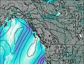
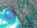
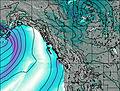
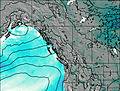
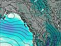
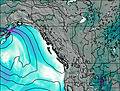
This table gives the weather forecast for Jack's Jump at the specific elevation of 1000 m. Our advanced weather models allow us to provide distinct weather forecasts for several elevations of Jack's Jump. To see the weather forecasts for the other elevations, use the tab navigation above the table. For a wider overview of the weather, consult the Weather Map of British-Columbia.
| Weather Station | Temp. | Weather | Wind | Gusts | Cloud / Visibility |
|---|---|---|---|---|---|
Clearwater Auto- BC | |||||
Blue River Cs- BC | |||||
Williams Lake Airport | |||||
Williams Lake A- BC | |||||
Jasper Warden Airport | |||||
Bleibler Ranch Airport | |||||
Clinton (Aut)- BC |
* NOTE: not all weather observatories update at the same frequency which is the reason why some locations may show data from stations that are further away than known closer ones.

