
– Lat/Long: 3.68° N 56.53° W
 Julianatop
Weather Forecast, SurinameIssued: 7 pm Fri 03 Apr Local TimeUpdates in: hr min sUpdate imminent
Issued: 7 pm Fri 03 Apr Local Time
Updates in:
Update imminent hr min s

Issued: 7 pm Fri 03 Apr Local Time
Updates in:
Update imminent hr min s
Days 1–4 Weather SummaryModerate rain (total 16mm), heaviest on Sat afternoon. Warm (max 20°C on Sat afternoon, min 18°C on Fri night). Winds increasing (light winds from the ESE on Sat morning, fresh winds from the E by Sun morning). | Days 5–7 Weather SummaryLight rain (total 8mm), mostly falling on Thu afternoon. Warm (max 21°C on Tue afternoon, min 18°C on Mon night). Winds decreasing (fresh winds from the E on Tue night, light winds from the ENE by Thu afternoon). | ||||||||||||||||||
Saturday 4 | Sunday 5 | Monday 6 | Tuesday 7 | Wednesday 8 | Thursday 9 | ||||||||||||||
night | AM | PM | night | AM | PM | night | AM | PM | night | AM | PM | night | AM | PM | night | AM | PM | night | |
risk tstorm | risk tstorm | risk tstorm | risk tstorm | rain shwrs | risk tstorm | rain shwrs | clear | risk tstorm | rain shwrs | risk tstorm | risk tstorm | risk tstorm | risk tstorm | risk tstorm | risk tstorm | risk tstorm | risk tstorm | rain shwrs | |
km/h | |||||||||||||||||||
 |  |  |  |  |  |  | |||||||||||||
— | — | — | — | — | — | — | — | — | — | — | — | — | — | — | — | — | — | — | |
4 | 0.9 | 7 | 3 | 0.2 | 0.7 | 0.6 | — | 0.3 | 0.4 | 0.2 | 0.3 | 0.9 | 0.3 | 1.2 | 2 | 0.5 | 2 | 1.4 | |
max °C | 19 | 19 | 20 | 19 | 18 | 20 | 19 | 19 | 20 | 19 | 19 | 21 | 19 | 19 | 20 | 19 | 19 | 19 | 18 |
min °C | 18 | 19 | 20 | 18 | 18 | 20 | 18 | 18 | 20 | 18 | 18 | 20 | 18 | 18 | 20 | 18 | 18 | 19 | 17 |
17 | 19 | 20 | 17 | 17 | 20 | 17 | 17 | 20 | 17 | 17 | 20 | 17 | 17 | 20 | 17 | 17 | 19 | 16 | |
4750 | 4850 | 4900 | 4900 | 4950 | 4900 | 4750 | 5000 | 5100 | 4850 | 4950 | 4950 | 4850 | 4950 | 4950 | 4800 | 5000 | 5000 | 4800 | |
Cloud base (m) | 300 | 600 | 5850 | 600 | 500 | 5850 | 400 | 500 | 1750 | 700 | 400 | 400 | 450 | 5500 | 750 | 400 | 5800 | 500 | |
— | 5:43 | — | — | 5:43 | — | — | 5:43 | — | — | 5:43 | — | — | 5:41 | — | — | 5:41 | — | — | |
— | — | 5:52 | — | — | 5:52 | — | — | 5:52 | — | — | 5:52 | — | — | 5:52 | — | — | 5:52 | — | |
Loading...
Julianatop Weather (Days 0-3):
The weather forecast for Julianatop is: Moderate rain (total 16mm), heaviest on Sat afternoon. Warm (max 20°C on Sat afternoon, min 18°C on Fri night). Winds increasing (light winds from the ESE on Sat morning, fresh winds from the E by Sun morning).
Julianatop Weather (Days 3-6):
Light rain (total 8mm), mostly falling on Thu afternoon. Warm (max 21°C on Tue afternoon, min 18°C on Mon night). Winds decreasing (fresh winds from the E on Tue night, light winds from the ENE by Thu afternoon).
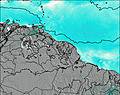
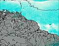
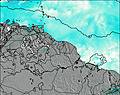
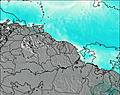
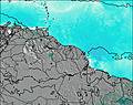
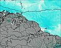
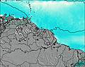
This table gives the weather forecast for Julianatop at the specific elevation of 1280 m. Our advanced weather models allow us to provide distinct weather forecasts for several elevations of Julianatop. To see the weather forecasts for the other elevations, use the tab navigation above the table. For a wider overview of the weather, consult the Weather Map of Suriname.
| Weather Station | Temp. | Weather | Wind | Gusts | Cloud / Visibility |
|---|---|---|---|---|---|
Paramaribo Airport | |||||
Saint -Laurent | |||||
Boa Vista (Aero) | |||||
Cayenn / ochambeau Airport | |||||
Cayenne Matoury |
* NOTE: not all weather observatories update at the same frequency which is the reason why some locations may show data from stations that are further away than known closer ones.