– Lat/Long: 63.43° N 130.32° W
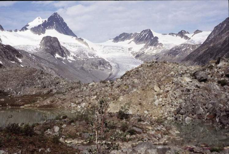
 Keele Peak
Weather Forecast, CanadaIssued: 11 pm Fri 03 Apr Local TimeUpdates in: hr min sUpdate imminent
Issued: 11 pm Fri 03 Apr Local Time
Updates in:
Update imminent hr min s

Issued: 11 pm Fri 03 Apr Local Time
Updates in:
Update imminent hr min s
Days 1–4 Weather SummaryMostly dry. Extremely cold (max -14°C on Mon afternoon, min -18°C on Fri night). Wind will be generally light. | Days 5–7 Weather SummaryA dusting of new snow. Extremely cold (max -14°C on Mon night, min -19°C on Thu morning). Winds increasing (calm on Mon night, strong winds from the WNW by Wed night). | ||||||||||||||||||
Saturday 4 | Sunday 5 | Monday 6 | Tuesday 7 | Wednesday 8 | Thursday 9 | ||||||||||||||
night | AM | PM | night | AM | PM | night | AM | PM | night | AM | PM | night | AM | PM | night | AM | PM | night | |
cloudy | cloudy | cloudy | some clouds | clear | clear | some clouds | cloudy | some clouds | cloudy | cloudy | cloudy | some clouds | some clouds | light snow | snow shwrs | snow shwrs | clear | some clouds | |
km/h | |||||||||||||||||||
 |  |  |  |  |  |  | |||||||||||||
— | — | — | — | — | — | — | — | — | — | — | — | — | — | 1 | 1 | 1 | — | — | |
— | — | — | — | — | — | — | — | — | — | — | — | — | — | — | — | — | — | — | |
max °C | -18 | -17 | -17 | -16 | -15 | -15 | -15 | -15 | -14 | -14 | -16 | -16 | -15 | -15 | -15 | -15 | -18 | -19 | -16 |
min °C | -18 | -18 | -17 | -16 | -16 | -15 | -15 | -15 | -14 | -16 | -16 | -17 | -16 | -15 | -15 | -16 | -19 | -19 | -18 |
-27 | -26 | -26 | -22 | -24 | -24 | -25 | -25 | -22 | -20 | -21 | -25 | -24 | -25 | -26 | -27 | -32 | -30 | -30 | |
0 | 0 | 0 | 0 | 0 | 400 | 0 | 0 | 600 | 0 | 0 | 650 | 0 | 0 | 650 | 0 | 0 | 600 | 0 | |
Cloud base (m) | 2200 | 1550 | 1550 | 1550 | 1550 | 1550 | 1550 | 1600 | 2600 | 1850 | 2350 | 1700 | 1550 | 1550 | 1550 | 1550 | 1550 | 1600 | 1850 |
— | 7:50 | — | — | 7:47 | — | — | 7:43 | — | — | 7:39 | — | — | 7:37 | — | — | 7:33 | — | — | |
— | — | — | 9:38 | — | — | 9:42 | — | — | 9:45 | — | — | 9:46 | — | — | 9:50 | — | — | 9:52 | |
Loading...
Keele Peak Weather (Days 0-3):
The weather forecast for Keele Peak is: Mostly dry. Extremely cold (max -14°C on Mon afternoon, min -18°C on Fri night). Wind will be generally light.
Keele Peak Weather (Days 3-6):
A dusting of new snow. Extremely cold (max -14°C on Mon night, min -19°C on Thu morning). Winds increasing (calm on Mon night, strong winds from the WNW by Wed night).
This table gives the weather forecast for Keele Peak at the specific elevation of 2972 m. Our advanced weather models allow us to provide distinct weather forecasts for several elevations of Keele Peak. To see the weather forecasts for the other elevations, use the tab navigation above the table. For a wider overview of the weather, consult the Weather Map of Yukon-Territory.
| Weather Station | Temp. | Weather | Wind | Gusts | Cloud / Visibility |
|---|---|---|---|---|---|
Macmillan Pass- YT | |||||
Faro (Aut)- YT | |||||
Rabbit Kettle- Nwt | |||||
Norman Wells Airport | |||||
Norman Wells Ua- Nwt | |||||
Mayo Airport | |||||
Fort Good Hope Cs- Nwt | |||||
Carmacks Cs- YT | |||||
Carmacks Airport |
* NOTE: not all weather observatories update at the same frequency which is the reason why some locations may show data from stations that are further away than known closer ones.
Keele Peak Photos
View all
Alaska/Yukon Ranges photos (65) |
photos from mountains in Canada (452) |
all photos
 Upload new photo
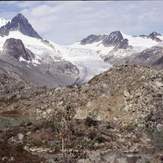
Keele Peak