
– Lat/Long: 32.78° N 49.32° E
 Keyno
Keyno
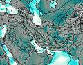
Weather Forecast, IranIssued: 8 am Sat 19 Apr Local TimeUpdates in: hr min sUpdate imminent
Keyno Weather Forecast, Iran
Issued: 8 am Sat 19 Apr Local Time
Updates in:
Update imminent hr min s

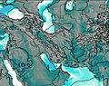
Issued: 8 am Sat 19 Apr Local Time
Updates in:
Update imminent hr min s
Days 1–3 Weather SummaryMostly dry. Mild temperatures (max 8°C on Mon night, min 3°C on Sat morning). Wind will be generally light. | Days 4–6 Weather SummaryMostly dry. Very mild (max 12°C on Thu afternoon, min 6°C on Tue morning). Wind will be generally light. | |||||||||||||||||
Saturday 19 | Sunday 20 | Monday 21 | Tuesday 22 | Wednesday 23 | Thursday 24 | |||||||||||||
AM | PM | night | AM | PM | night | AM | PM | night | AM | PM | night | AM | PM | night | AM | PM | night | |
clear | clear | clear | clear | clear | clear | clear | cloudy | rain shwrs | light rain | rain shwrs | clear | clear | clear | clear | clear | clear | clear | |
km/h | ||||||||||||||||||
 |  |  |  |  |  | |||||||||||||
— | — | — | — | — | — | — | — | — | — | — | — | — | — | — | — | — | — | |
— | — | — | — | — | — | — | — | 0.1 | 0.2 | 0.1 | — | — | — | — | — | — | — | |
max°C | 4 | 5 | 5 | 5 | 6 | 6 | 6 | 7 | 8 | 6 | 8 | 8 | 9 | 10 | 9 | 11 | 12 | 11 |
min°C | 3 | 5 | 4 | 5 | 6 | 5 | 6 | 7 | 7 | 6 | 7 | 7 | 8 | 10 | 9 | 10 | 11 | 11 |
2 | 5 | 3 | 4 | 6 | 5 | 4 | 6 | 5 | 4 | 5 | 5 | 8 | 9 | 9 | 8 | 9 | 10 | |
3400 | 3650 | 3600 | 3600 | 3800 | 3750 | 3850 | 3950 | 3950 | 3800 | 3950 | 4000 | 4050 | 4300 | 4200 | 4350 | 4550 | 4550 | |
Cloud base (m) | 8900 | 9300 | 7200 | 5050 | 6750 | |||||||||||||
5:37 | — | — | 5:37 | — | — | 5:35 | — | — | 5:35 | — | — | 5:33 | — | — | 5:33 | — | — | |
— | 6:45 | — | — | 6:45 | — | — | 6:45 | — | — | 6:46 | — | — | 6:47 | — | — | 6:49 | — | |
Loading...
Keyno Weather (Days 0-3):
The weather forecast for Keyno is: Mostly dry. Mild temperatures (max 8°C on Mon night, min 3°C on Sat morning). Wind will be generally light.
Keyno Weather (Days 3-6):
Mostly dry. Very mild (max 12°C on Thu afternoon, min 6°C on Tue morning). Wind will be generally light.
This table gives the weather forecast for Keyno at the specific elevation of 3000 m. Our advanced weather models allow us to provide distinct weather forecasts for several elevations of Keyno. To see the weather forecasts for the other elevations, use the tab navigation above the table. For a wider overview of the weather, consult the Weather Map of Iran.
| Weather Station | Temp. | Weather | Wind | Gusts | Cloud / Visibility |
|---|---|---|---|---|---|
Ali Goodarz | |||||
Masjed Soleyman | |||||
Safi-AbadDezful | |||||
Khoram Abad Airport | |||||
Khorram Abad | |||||
Arak(40769-0) | |||||
Arak Airport | |||||
Shahre-Kord Airport | |||||
Shahre-Kord | |||||
* NOTE: not all weather observatories update at the same frequency which is the reason why some locations may show data from stations that are further away than known closer ones.
Keyno Photos
View all
photos (495) |
Iranian Plateau photos (1913) |
photos from mountains in Iran (11696) |
all photos
 Upload new photo
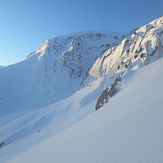
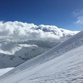
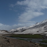
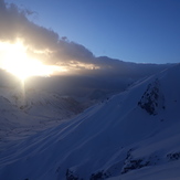
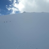
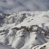
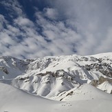 See 13 more Keyno photos
Keyno
Keyno
keyno
Keyno
Keyno
Sadegh salehi
Sadegh salehi

