
– Lat/Long: 38.53° N 128.05° E
 Kŭmgangsan
Weather Forecast, Korea NIssued: 8 am Sat 26 Apr Local TimeUpdates in: hr min sUpdate imminent
Kŭmgangsan Weather Forecast, Korea N
Issued: 8 am Sat 26 Apr Local Time
Updates in:
Update imminent hr min s

Issued: 8 am Sat 26 Apr Local Time
Updates in:
Update imminent hr min s
Days 1–3 Weather SummaryMostly dry. Freeze-thaw conditions (max 10°C on Sat night, min 0°C on Mon morning). Winds decreasing (stormy winds from the W on Sat night, moderate winds from the NW by Mon night). | Days 4–6 Weather SummaryLight rain (total 10mm) at first, then becoming colder with a dusting of snow on Thu night. Freeze-thaw conditions (max 11°C on Wed night, min -2°C on Thu night). Winds decreasing (gales from the WSW on Tue night, light winds from the WSW by Thu night). | |||||||||||||||||
Saturday 26 | Sunday 27 | Monday 28 | Tuesday 29 | Wednesday 30 | Thursday 1 | |||||||||||||
AM | PM | night | AM | PM | night | AM | PM | night | AM | PM | night | AM | PM | night | AM | PM | night | |
clear | clear | clear | some clouds | some clouds | clear | clear | clear | clear | clear | clear | some clouds | clear | clear | some clouds | light rain | mod. rain | snow shwrs | |
km/h | ||||||||||||||||||
 |  |  |  |  |  | |||||||||||||
— | — | — | — | — | — | — | — | — | — | — | — | — | — | — | — | — | 2.0 | |
— | — | — | — | — | — | — | — | — | — | — | — | — | — | — | 0.1 | 6 | 4 | |
max°C | 3 | 6 | 10 | 5 | 5 | 3 | 2 | 4 | 3 | 5 | 6 | 9 | 9 | 10 | 11 | 7 | 6 | 3 |
min°C | 3 | 5 | 7 | 5 | 5 | 1 | 0 | 3 | 3 | 4 | 6 | 7 | 8 | 10 | 8 | 5 | 5 | -2 |
-5 | -2 | 0 | -3 | -2 | -8 | -8 | -3 | -2 | 0 | 1 | 1 | 2 | 6 | 3 | -2 | -2 | -10 | |
2100 | 2700 | 3250 | 2800 | 2600 | 2150 | 1600 | 2050 | 2000 | 2250 | 2750 | 3050 | 2950 | 3050 | 3150 | 2900 | 2600 | 1800 | |
Cloud base (m) | 1600 | 9000 | 2900 | 2950 | 5150 | 6050 | 6500 | 6200 | 2900 | 1850 | 650 | |||||||
5:37 | — | — | 5:35 | — | — | 5:35 | — | — | 5:33 | — | — | 5:31 | — | — | 5:31 | — | — | |
— | 7:14 | — | — | 7:15 | — | — | 7:15 | — | — | 7:16 | — | — | 7:17 | — | — | 7:19 | — | |
Loading...
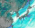
Kŭmgangsan Weather (Days 0-3):
The weather forecast for Kŭmgangsan is: Mostly dry. Freeze-thaw conditions (max 10°C on Sat night, min 0°C on Mon morning). Winds decreasing (stormy winds from the W on Sat night, moderate winds from the NW by Mon night).
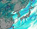
Kŭmgangsan Weather (Days 3-6):
Light rain (total 10mm) at first, then becoming colder with a dusting of snow on Thu night. Freeze-thaw conditions (max 11°C on Wed night, min -2°C on Thu night). Winds decreasing (gales from the WSW on Tue night, light winds from the WSW by Thu night).
This table gives the weather forecast for Kŭmgangsan at the specific elevation of 1638 m. Our advanced weather models allow us to provide distinct weather forecasts for several elevations of Kŭmgangsan. To see the weather forecasts for the other elevations, use the tab navigation above the table. For a wider overview of the weather, consult the Weather Map of North Korea.
| Weather Station | Temp. | Weather | Wind | Gusts | Cloud / Visibility |
|---|---|---|---|---|---|
Bangsan RWS Airport | |||||
Yangku Airport | |||||
Sinnam Airport | |||||
Sachang | |||||
Hongcheon Airport | |||||
Whang Ryeong |
* NOTE: not all weather observatories update at the same frequency which is the reason why some locations may show data from stations that are further away than known closer ones.

