– Lat/Long: 62.61° N 7.90° E
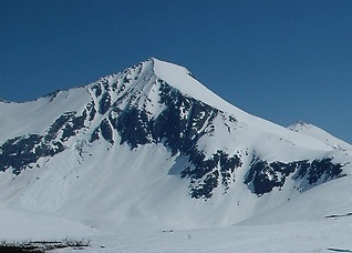
 Kyrkjetaket
Weather Forecast, NorwayIssued: 1 pm Thu 24 Apr Local TimeUpdates in: hr min sUpdate imminent
Kyrkjetaket Weather Forecast, Norway
Issued: 1 pm Thu 24 Apr Local Time
Updates in:
Update imminent hr min s

Issued: 1 pm Thu 24 Apr Local Time
Updates in:
Update imminent hr min s
Days 1–4 Weather SummaryMostly dry. Freeze-thaw conditions (max 1°C on Sat afternoon, min -8°C on Thu night). Wind will be generally light. | Days 5–7 Weather SummaryA moderate fall of snow, heaviest on Tue night. Freeze-thaw conditions (max 3°C on Sun afternoon, min -2°C on Mon night). Winds increasing (calm on Sun afternoon, fresh winds from the W by Mon night). | ||||||||||||||||
Thu 24 | Friday 25 | Saturday 26 | Sunday 27 | Monday 28 | Tuesday 29 | ||||||||||||
PM | night | AM | PM | night | AM | PM | night | AM | PM | night | AM | PM | night | AM | PM | night | |
cloudy | some clouds | clear | clear | clear | clear | clear | some clouds | some clouds | cloudy | cloudy | light snow | cloudy | light snow | some clouds | light rain | mod. snow | |
km/h | |||||||||||||||||
 |  |  |  |  |  | ||||||||||||
— | — | — | — | — | — | — | — | — | — | — | 1.0 | — | 1.0 | — | — | 10 | |
— | — | — | — | — | — | — | — | — | — | — | — | — | — | — | 0.4 | — | |
max°C | -7 | -7 | -5 | -4 | -1 | 0 | 1 | 1 | 1 | 3 | 3 | 0 | 0 | -1 | -1 | 2 | 2 |
min°C | -7 | -8 | -6 | -5 | -3 | 0 | 0 | 1 | 0 | 2 | 0 | -1 | -1 | -2 | -1 | 2 | -2 |
-12 | -12 | -6 | -5 | -6 | -2 | -2 | -2 | -2 | 1 | -4 | -6 | -8 | -8 | -6 | -3 | -9 | |
650 | 350 | 750 | 1000 | 1000 | 1450 | 1600 | 1650 | 1550 | 1850 | 1750 | 1400 | 1350 | 1250 | 1350 | 1800 | 1350 | |
Cloud base (m) | 1500 | 750 | 5550 | 4900 | 8900 | 8500 | 8100 | 2500 | 2150 | 650 | 750 | 650 | 1600 | 700 | 650 | ||
— | — | 5:31 | — | — | 5:28 | — | — | 5:24 | — | — | 5:22 | — | — | 5:18 | — | — | |
— | 9:19 | — | — | 9:22 | — | — | 9:24 | — | — | 9:28 | — | — | 9:30 | — | — | 9:34 | |
Loading...
Kyrkjetaket Weather (Days 0-3):
The weather forecast for Kyrkjetaket is: Mostly dry. Freeze-thaw conditions (max 1°C on Sat afternoon, min -8°C on Thu night). Wind will be generally light.
Kyrkjetaket Weather (Days 3-6):
A moderate fall of snow, heaviest on Tue night. Freeze-thaw conditions (max 3°C on Sun afternoon, min -2°C on Mon night). Winds increasing (calm on Sun afternoon, fresh winds from the W by Mon night).
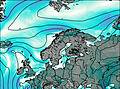
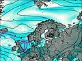
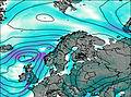
This table gives the weather forecast for Kyrkjetaket at the specific elevation of 1439 m. Our advanced weather models allow us to provide distinct weather forecasts for several elevations of Kyrkjetaket. To see the weather forecasts for the other elevations, use the tab navigation above the table. For a wider overview of the weather, consult the Weather Map of Norway.
| Weather Station | Temp. | Weather | Wind | Gusts | Cloud / Visibility |
|---|---|---|---|---|---|
Romsdalsgondolen Fje | |||||
Romsdalsgondolen Fjo | |||||
Marstein | |||||
Flemma | |||||
Malmefjorden- ener'n | |||||
Vestnes KRIK | |||||
Bjorli Skisenter AS | |||||
Bjorli | |||||
* NOTE: not all weather observatories update at the same frequency which is the reason why some locations may show data from stations that are further away than known closer ones.
Kyrkjetaket Photos
View all
Scandinavia/European Arctic Ranges photos (14) |
photos from mountains in Norway (113) |
all photos
 Upload new photo
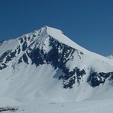
Kyrkjetaket

