– Lat/Long: 39.63° S 71.50° W
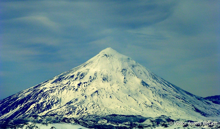
 Lanín
Lanín
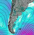
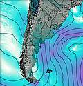
Weather Forecast, ArgentinaIssued: 8 pm Tue 01 Apr Local TimeUpdates in: hr min sUpdate imminent
Lanín Weather Forecast, Argentina
Issued: 8 pm Tue 01 Apr Local Time
Updates in:
Update imminent hr min s

Issued: 8 pm Tue 01 Apr Local Time
Updates in:
Update imminent hr min s
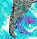
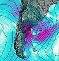
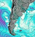
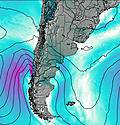
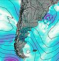
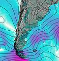
Days 1–4 Weather SummaryA dusting of new snow. Freeze-thaw conditions (max 7°C on Fri afternoon, min -5°C on Tue night). Winds decreasing (severe gales from the W on Wed morning, calm by Thu afternoon). | Days 5–7 Weather SummaryMostly dry. Mild temperatures (max 8°C on Fri night, min 5°C on Sat afternoon). Winds increasing (light winds from the NW on Sun morning, fresh winds from the WNW by Mon morning). | Days 8–10 Weather SummaryMostly dry. Freeze-thaw conditions (max 7°C on Mon night, min -2°C on Wed afternoon). Winds decreasing (strong winds from the WNW on Tue night, calm by Thu morning). | Days 11–13 Weather SummaryA dusting of new snow. Temperatures will be below freezing (max 0°C on Thu night, min -7°C on Sun night). Winds increasing (light winds from the WNW on Thu night, strong winds from the W by Sat night). | |||||||||||||||||||||||||||||||||
Wednesday 2 | Thursday 3 | Friday 4 | Saturday 5 | Sunday 6 | Monday 7 | Tuesday 8 | Wednesday 9 | Thursday 10 | Friday 11 | Saturday 12 | Sun 13 | |||||||||||||||||||||||||
night | AM | PM | night | AM | PM | night | AM | PM | night | AM | PM | night | AM | PM | night | AM | PM | night | AM | PM | night | AM | PM | night | AM | PM | night | AM | PM | night | AM | PM | night | AM | PM | |
clear | snow shwrs | light snow | some clouds | clear | clear | clear | clear | some clouds | some clouds | some clouds | some clouds | clear | clear | clear | clear | clear | clear | clear | some clouds | some clouds | some clouds | some clouds | some clouds | some clouds | clear | clear | clear | some clouds | some clouds | cloudy | cloudy | some clouds | snow shwrs | clear | some clouds | |
km/h | ||||||||||||||||||||||||||||||||||||
 |  |  |  |  |  |  |  |  |  |  |  | |||||||||||||||||||||||||
— | 1.0 | 2.0 | — | — | — | — | — | — | — | — | — | — | — | — | — | — | — | — | — | — | — | — | — | — | — | — | — | — | — | — | — | — | 2.0 | — | — | |
— | — | — | — | — | — | — | — | — | — | — | — | — | — | — | — | — | — | — | — | — | — | — | — | — | — | — | — | — | — | — | — | — | — | — | — | |
max°C | -3 | -4 | -4 | 0 | 1 | 3 | 5 | 6 | 7 | 8 | 6 | 6 | 6 | 7 | 7 | 7 | 7 | 7 | 7 | 6 | 6 | 4 | 1 | -1 | -1 | -1 | -1 | 0 | 0 | -1 | -1 | -3 | -4 | -4 | -5 | -5 |
min°C | -5 | -4 | -5 | -4 | 1 | 2 | 3 | 5 | 7 | 6 | 6 | 5 | 6 | 6 | 7 | 7 | 7 | 7 | 5 | 6 | 5 | 1 | 0 | -2 | -2 | -1 | -1 | -1 | 0 | -1 | -2 | -4 | -5 | -5 | -6 | -6 |
-17 | -15 | -17 | -15 | -6 | 2 | 2 | 3 | 5 | 2 | 2 | 0 | 1 | 4 | 4 | 3 | 2 | 2 | 0 | 2 | 0 | -6 | -7 | -9 | -9 | -4 | -3 | -5 | -4 | -6 | -10 | -13 | -14 | -15 | -16 | -15 | |
2150 | 1500 | 1750 | 2650 | 3250 | 3350 | 3700 | 1250 | 4100 | 4100 | 3950 | 3850 | 3900 | 4000 | 4050 | 4150 | 4100 | 3950 | 4000 | 3900 | 3800 | 3650 | 3100 | 2850 | 2750 | 2750 | 2850 | 3000 | 2900 | 2900 | 2750 | 2550 | 2450 | 2100 | 2050 | 2300 | |
Cloud base (m) | 1650 | 1500 | 900 | 900 | 950 | 8850 | 8700 | 6600 | 6050 | 5200 | 4350 | 4900 | 6550 | 6200 | 4900 | 3350 | 900 | 900 | 1550 | |||||||||||||||||
— | 8:00 | — | — | 8:02 | — | — | 8:03 | — | — | 8:03 | — | — | 8:04 | — | — | 8:06 | — | — | 8:07 | — | — | 8:07 | — | — | 8:08 | — | — | 8:10 | — | — | 8:11 | — | — | 8:11 | — | |
— | — | 7:36 | — | — | 7:34 | — | — | 7:32 | — | — | 7:30 | — | — | 7:30 | — | — | 7:28 | — | — | 7:27 | — | — | 7:24 | — | — | 7:23 | — | — | 7:22 | — | — | 7:21 | — | — | 7:19 | |
Lanín Weather (Days 0-3):
The weather forecast for Lanín is: A dusting of new snow. Freeze-thaw conditions (max 7°C on Fri afternoon, min -5°C on Tue night). Winds decreasing (severe gales from the W on Wed morning, calm by Thu afternoon).
Lanín Weather (Days 3-6):
Mostly dry. Mild temperatures (max 8°C on Fri night, min 5°C on Sat afternoon). Winds increasing (light winds from the NW on Sun morning, fresh winds from the WNW by Mon morning).
Lanín Weather (Days 6-9):
Mostly dry. Freeze-thaw conditions (max 7°C on Mon night, min -2°C on Wed afternoon). Winds decreasing (strong winds from the WNW on Tue night, calm by Thu morning).
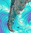
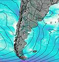
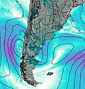
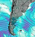
This table gives the weather forecast for Lanín at the specific elevation of 3000 m. Our advanced weather models allow us to provide distinct weather forecasts for several elevations of Lanín. To see the weather forecasts for the other elevations, use the tab navigation above the table. For a wider overview of the weather, consult the Weather Map of Argentina.
| Weather Station | Temp. | Weather | Wind | Gusts | Cloud / Visibility |
|---|---|---|---|---|---|
Temuco Airport | |||||
Valdivi / ichoy Airport | |||||
Valdivia | |||||
Maquehue -Ufro | |||||
Temuco | |||||
Osorn / añal Bajo Carlos Hott Siebert Airport | |||||
Escuela Mirasol- Puerto Montt |
* NOTE: not all weather observatories update at the same frequency which is the reason why some locations may show data from stations that are further away than known closer ones.
Lanín Photos
View all
Central Argentina-Chile photos (457) |
Andes photos (970) |
photos from mountains in Argentina (244) |
all photos
 Upload new photo
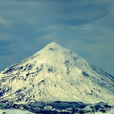

 See 14 more Lanín photos
Lanín Volcano
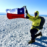
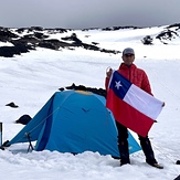
Cumbre volcán Lanin
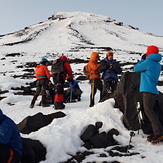
De regreso, a los 2450msnm
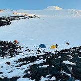
campamento base volcan lanin Peripillan Expediciones
Camp. Base 2.500 msnm
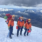
Lanin 3000 msnm

