– Lat/Long: 27.96° N 86.79° E
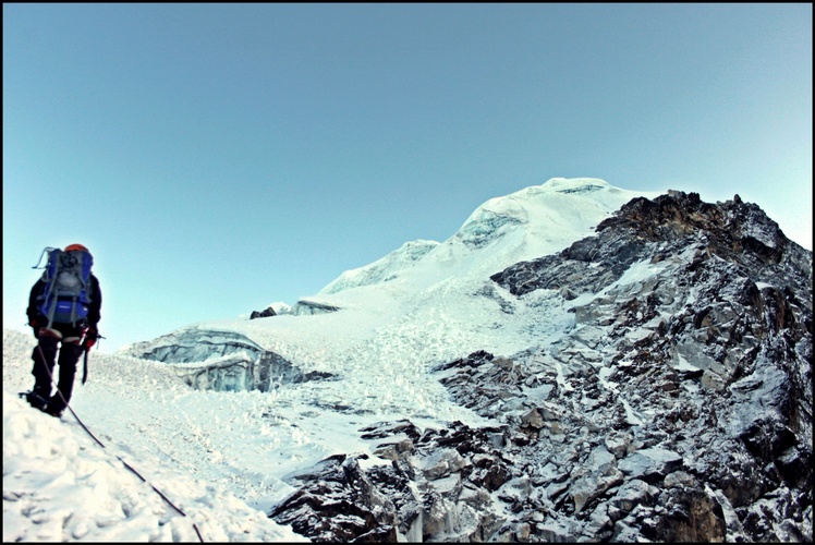
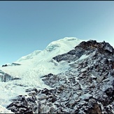
 Lobuche East
Weather Forecast, NepalIssued: 4 pm Sun 14 Dec Local TimeUpdates in: hr min sUpdate imminent
Issued: 4 pm Sun 14 Dec Local Time
Updates in:
Update imminent hr min s

Issued: 4 pm Sun 14 Dec Local Time
Updates in:
Update imminent hr min s
Days 1–4 Weather SummaryMostly dry. Extremely cold (max -13°C on Wed morning, min -17°C on Sun afternoon). Winds increasing (light winds from the WNW on Sun night, near gales from the NW by Mon night). | Days 5–7 Weather SummaryMostly dry. Temperatures will be well below freezing (max -9°C on Sat morning, min -15°C on Wed afternoon). Mainly strong winds. | ||||||||||||||||
Sun 14 | Monday 15 | Tuesday 16 | Wednesday 17 | Thursday 18 | Friday 19 | ||||||||||||
PM | night | AM | PM | night | AM | PM | night | AM | PM | night | AM | PM | night | AM | PM | night | |
clear | clear | clear | clear | clear | clear | clear | clear | clear | clear | clear | clear | clear | clear | clear | clear | clear | |
km/h | |||||||||||||||||
 |  |  |  |  |  | ||||||||||||
— | — | — | — | — | — | — | — | — | — | — | — | — | — | — | — | — | |
— | — | — | — | — | — | — | — | — | — | — | — | — | — | — | — | — | |
max°C | -15 | -16 | -14 | -15 | -16 | -14 | -14 | -16 | -13 | -13 | -14 | -12 | -12 | -13 | -11 | -11 | -12 |
min°C | -17 | -17 | -15 | -16 | -17 | -15 | -16 | -17 | -15 | -15 | -14 | -13 | -13 | -13 | -12 | -12 | -12 |
-28 | -28 | -25 | -25 | -30 | -28 | -30 | -30 | -27 | -26 | -25 | -24 | -24 | -24 | -24 | -23 | -23 | |
3150 | 3250 | 4050 | 3300 | 3100 | 4050 | 3550 | 3250 | 4200 | 3650 | 3850 | 4500 | 4050 | 4050 | 4650 | 4150 | 4050 | |
Cloud base (m) | |||||||||||||||||
— | — | 6:41 | — | — | 6:41 | — | — | 6:41 | — | — | 6:43 | — | — | 6:43 | — | — | |
5:04 | — | — | 5:04 | — | — | 5:04 | — | — | 5:05 | — | — | 5:05 | — | — | 5:05 | — | |
Loading...
Lobuche East Weather (Days 0-3):
The weather forecast for Lobuche East is: Mostly dry. Extremely cold (max -13°C on Wed morning, min -17°C on Sun afternoon). Winds increasing (light winds from the WNW on Sun night, near gales from the NW by Mon night).
Lobuche East Weather (Days 3-6):
Mostly dry. Temperatures will be well below freezing (max -9°C on Sat morning, min -15°C on Wed afternoon). Mainly strong winds.
This table gives the weather forecast for Lobuche East at the specific elevation of 6119 m. Our advanced weather models allow us to provide distinct weather forecasts for several elevations of Lobuche East. To see the weather forecasts for the other elevations, use the tab navigation above the table. For a wider overview of the weather, consult the Weather Map of Nepal.
| Weather Station | Temp. | Weather | Wind | Gusts | Cloud / Visibility |
|---|---|---|---|---|---|
Tingri | |||||
Pakyong Airport- Pakyong | |||||
* NOTE: not all weather observatories update at the same frequency which is the reason why some locations may show data from stations that are further away than known closer ones.
Lobuche East Photos
View all
Central Nepal Himalaya photos (162) |
Greater Himalaya photos (318) |
photos from mountains in Nepal (247) |
all photos
 Upload new photo


 See 12 more Lobuche East photos
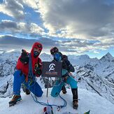
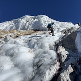
Alpinist Climber Expeditions
Lobuche Peak
Alpinist Climber Expeditions
Alpinist Climber Expeditions
Alpinist Climber Expeditions
Lobuche peak summit point
Above the Crampons point descending