
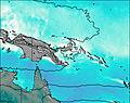
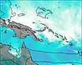
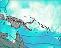
– Lat/Long: 5.36° S 147.12° E
 Long Island
Weather Forecast, Papua New GuineaIssued: 9 pm Wed 16 Apr Local TimeUpdates in: hr min sUpdate imminent
Long Island Weather Forecast, Papua New Guinea
Issued: 9 pm Wed 16 Apr Local Time
Updates in:
Update imminent hr min s

Issued: 9 pm Wed 16 Apr Local Time
Updates in:
Update imminent hr min s
Days 1–4 Weather SummaryHeavy rain (total 50mm), heaviest during Wed night. Warm (max 20°C on Thu morning, min 19°C on Wed night). Wind will be generally light. | Days 5–7 Weather SummaryModerate rain (total 16mm), heaviest on Sun morning. Warm (max 21°C on Sat night, min 19°C on Sun morning). Wind will be generally light. | ||||||||||||||||||
Thursday 17 | Friday 18 | Saturday 19 | Sunday 20 | Monday 21 | Tuesday 22 | ||||||||||||||
night | AM | PM | night | AM | PM | night | AM | PM | night | AM | PM | night | AM | PM | night | AM | PM | night | |
risk tstorm | risk tstorm | risk tstorm | risk tstorm | risk tstorm | risk tstorm | risk tstorm | risk tstorm | risk tstorm | rain shwrs | mod. rain | light rain | rain shwrs | risk tstorm | clear | rain shwrs | risk tstorm | risk tstorm | risk tstorm | |
km/h | |||||||||||||||||||
 |  |  |  |  |  |  | |||||||||||||
— | — | — | — | — | — | — | — | — | — | — | — | — | — | — | — | — | — | — | |
15 | 3 | 2 | 12 | 2 | 4 | 4 | 5 | 3 | 0.6 | 8 | 0.2 | 0.5 | 2 | — | 1.4 | 1.9 | 1.7 | 10 | |
max°C | 19 | 20 | 20 | 19 | 20 | 19 | 20 | 20 | 20 | 21 | 20 | 20 | 20 | 20 | 20 | 20 | 20 | 20 | 20 |
min°C | 19 | 20 | 20 | 19 | 19 | 19 | 19 | 20 | 20 | 20 | 19 | 19 | 20 | 20 | 20 | 20 | 20 | 20 | 20 |
19 | 20 | 20 | 19 | 19 | 19 | 19 | 20 | 20 | 20 | 19 | 19 | 20 | 20 | 20 | 20 | 20 | 20 | 20 | |
5000 | 5000 | 5050 | 5050 | 5000 | 5100 | 5000 | 5000 | 5000 | 4950 | 5050 | 5050 | 5000 | 5000 | 5000 | 4950 | 4950 | 5050 | 4950 | |
Cloud base (m) | 1500 | 300 | 4500 | 5500 | 3100 | 4850 | 3300 | 2550 | 2800 | 2800 | 750 | 400 | 5050 | 3600 | 2750 | 800 | |||
— | 6:11 | — | — | 6:11 | — | — | 6:11 | — | — | 6:11 | — | — | 6:11 | — | — | 6:11 | — | — | |
— | — | 6:09 | — | — | 6:09 | — | — | 6:08 | — | — | 6:08 | — | — | 6:08 | — | — | 6:07 | — | |
Loading...
Long Island Weather (Days 0-3):
The weather forecast for Long Island is: Heavy rain (total 50mm), heaviest during Wed night. Warm (max 20°C on Thu morning, min 19°C on Wed night). Wind will be generally light.
Long Island Weather (Days 3-6):
Moderate rain (total 16mm), heaviest on Sun morning. Warm (max 21°C on Sat night, min 19°C on Sun morning). Wind will be generally light.
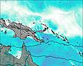
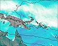
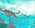
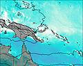
This table gives the weather forecast for Long Island at the specific elevation of 1280 m. Our advanced weather models allow us to provide distinct weather forecasts for several elevations of Long Island. To see the weather forecasts for the other elevations, use the tab navigation above the table. For a wider overview of the weather, consult the Weather Map of Papua New Guinea.
| Weather Station | Temp. | Weather | Wind | Gusts | Cloud / Visibility |
|---|---|---|---|---|---|
Goroka Highlands Airport | |||||
ASCATB149E5S | |||||
ASCATB149E4S | |||||
ASCATB150E7S | |||||
ASCATB150E5S | |||||
ASCATB149E3S | |||||
ASCATB150E4S | |||||
ASCATB151E5S | |||||
ASCATB150E3S |
* NOTE: not all weather observatories update at the same frequency which is the reason why some locations may show data from stations that are further away than known closer ones.

