– Lat/Long: 48.45° N 121.06° W
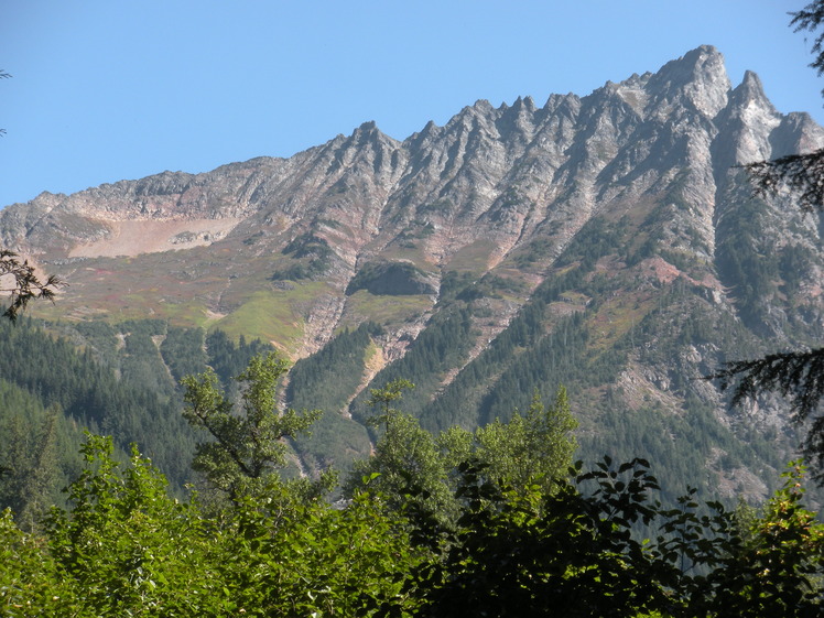
 Mix-up Peak
Weather Forecast, United StatesIssued: 4 pm Mon 28 Apr Local TimeUpdates in: hr min sUpdate imminent
Mix-up Peak Weather Forecast, United States
Issued: 4 pm Mon 28 Apr Local Time
Updates in:
Update imminent hr min s

Issued: 4 pm Mon 28 Apr Local Time
Updates in:
Update imminent hr min s
Days 1–4 Weather SummaryA dusting of new snow. Freeze-thaw conditions (max 12°C on Thu morning, min -2°C on Tue night). Wind will be generally light. | Days 5–7 Weather SummaryLight rain (total 9mm), mostly falling on Sat morning. Very mild (max 17°C on Fri afternoon, min 4°C on Sat night). Wind will be generally light. | ||||||||||||||||
Mon 28 | Tuesday 29 | Wednesday 30 | Thursday 1 | Friday 2 | Saturday 3 | ||||||||||||
PM | night | AM | PM | night | AM | PM | night | AM | PM | night | AM | PM | night | AM | PM | night | |
light rain | light snow | cloudy | light rain | some clouds | clear | clear | clear | clear | clear | clear | clear | some clouds | rain shwrs | light rain | light rain | rain shwrs | |
km/h | |||||||||||||||||
 |  |  |  |  |  | ||||||||||||
— | 2.0 | — | — | — | — | — | — | — | — | — | — | — | — | — | — | — | |
0.2 | — | — | 0.6 | — | — | — | — | — | — | — | — | — | 1.6 | 5 | 2 | 0.4 | |
max°C | 4 | 1 | 1 | 4 | 1 | 5 | 10 | 7 | 12 | 16 | 12 | 14 | 17 | 13 | 7 | 6 | 5 |
min°C | 2 | 0 | 1 | 3 | -2 | 0 | 9 | 4 | 7 | 15 | 7 | 10 | 17 | 6 | 5 | 5 | 4 |
0 | -2 | -1 | 0 | -2 | 0 | 9 | 4 | 6 | 15 | 6 | 10 | 17 | 5 | 5 | 3 | 3 | |
2100 | 1650 | 1700 | 1950 | 1400 | 2450 | 2900 | 3250 | 3300 | 3200 | 3350 | 3250 | 3350 | 3000 | 2950 | 2700 | 3150 | |
Cloud base (m) | 1800 | 1600 | 1600 | 1750 | 1600 | 1600 | 2300 | 3450 | 1800 | 1650 | 1600 | 1650 | |||||
— | — | 5:48 | — | — | 5:47 | — | — | 5:45 | — | — | 5:43 | — | — | 5:41 | — | — | |
— | 8:13 | — | — | 8:15 | — | — | 8:15 | — | — | 8:17 | — | — | 8:19 | — | — | 8:21 | |
Loading...
Mix-up Peak Weather (Days 0-3):
The weather forecast for Mix-up Peak is: A dusting of new snow. Freeze-thaw conditions (max 12°C on Thu morning, min -2°C on Tue night). Wind will be generally light.
Mix-up Peak Weather (Days 3-6):
Light rain (total 9mm), mostly falling on Sat morning. Very mild (max 17°C on Fri afternoon, min 4°C on Sat night). Wind will be generally light.
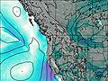
This table gives the weather forecast for Mix-up Peak at the specific elevation of 1500 m. Our advanced weather models allow us to provide distinct weather forecasts for several elevations of Mix-up Peak. To see the weather forecasts for the other elevations, use the tab navigation above the table. For a wider overview of the weather, consult the Weather Map of Washington.
| Weather Station | Temp. | Weather | Wind | Gusts | Cloud / Visibility |
|---|---|---|---|---|---|
Agassiz Airport | |||||
BUOY-PBFW1 |
* NOTE: not all weather observatories update at the same frequency which is the reason why some locations may show data from stations that are further away than known closer ones.
Mix-up Peak Photos
View all
Cascade Range photos (426) |
Pacific Coast Ranges photos (1000) |
photos from mountains in United States (2893) |
all photos
 Upload new photo
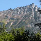
South side of Mix Up Peak

