– Lat/Long: 44.83° N 5.55° E
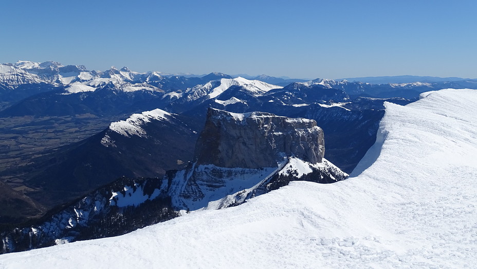
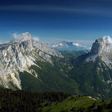
 Mont Aiguille
Weather Forecast, FranceIssued: 7 pm Wed 23 Apr Local TimeUpdates in: hr min sUpdate imminent
Mont Aiguille Weather Forecast, France
Issued: 7 pm Wed 23 Apr Local Time
Updates in:
Update imminent hr min s

Issued: 7 pm Wed 23 Apr Local Time
Updates in:
Update imminent hr min s
Days 1–4 Weather SummaryModerate rain (total 13mm), heaviest on Wed night. Mild temperatures (max 9°C on Sat afternoon, min 2°C on Wed night). Winds decreasing (fresh winds from the N on Wed night, calm by Sat morning). | Days 5–7 Weather SummaryModerate rain (total 18mm), heaviest on Sat night. Mild temperatures (max 8°C on Tue afternoon, min 3°C on Sat night). Wind will be generally light. | ||||||||||||||||||
Thursday 24 | Friday 25 | Saturday 26 | Sunday 27 | Monday 28 | Tuesday 29 | ||||||||||||||
night | AM | PM | night | AM | PM | night | AM | PM | night | AM | PM | night | AM | PM | night | AM | PM | night | |
rain shwrs | rain shwrs | rain shwrs | rain shwrs | clear | clear | clear | some clouds | light rain | heavy rain | light rain | light rain | cloudy | rain shwrs | rain shwrs | rain shwrs | rain shwrs | risk tstorm | rain shwrs | |
km/h | |||||||||||||||||||
 |  |  |  |  |  |  | |||||||||||||
— | — | — | — | — | — | — | — | — | — | — | — | — | — | — | — | — | — | — | |
12 | 0.1 | 0.1 | 0.1 | — | — | — | — | 0.7 | 11 | 0.3 | 0.2 | — | 0.1 | 0.2 | 0.1 | 0.6 | 6 | 1.7 | |
max°C | 3 | 2 | 5 | 3 | 4 | 8 | 6 | 7 | 9 | 4 | 3 | 3 | 4 | 4 | 7 | 7 | 7 | 8 | 7 |
min°C | 2 | 2 | 4 | 2 | 2 | 7 | 5 | 6 | 7 | 3 | 3 | 3 | 4 | 3 | 7 | 6 | 6 | 8 | 7 |
0 | -4 | -1 | -4 | -4 | 3 | 1 | 6 | 5 | 0 | -1 | 0 | 0 | 0 | 5 | 5 | 5 | 6 | 6 | |
1900 | 2300 | 2600 | 2950 | 3000 | 3150 | 3200 | 2850 | 2550 | 2150 | 2350 | 2350 | 2250 | 2200 | 2550 | 2550 | 2500 | 2550 | 2600 | |
Cloud base (m) | 700 | 850 | 2050 | 1750 | 800 | 2200 | 8600 | 6900 | 1750 | 650 | 750 | 900 | 1850 | 1550 | 1900 | 2200 | 2150 | 2350 | 2500 |
— | 6:39 | — | — | 6:37 | — | — | 6:35 | — | — | 6:33 | — | — | 6:33 | — | — | 6:31 | — | — | |
— | — | — | 8:32 | — | — | 8:34 | — | — | 8:36 | — | — | 8:37 | — | — | 8:37 | — | — | 8:38 | |
Loading...
Mont Aiguille Weather (Days 0-3):
The weather forecast for Mont Aiguille is: Moderate rain (total 13mm), heaviest on Wed night. Mild temperatures (max 9°C on Sat afternoon, min 2°C on Wed night). Winds decreasing (fresh winds from the N on Wed night, calm by Sat morning).
Mont Aiguille Weather (Days 3-6):
Moderate rain (total 18mm), heaviest on Sat night. Mild temperatures (max 8°C on Tue afternoon, min 3°C on Sat night). Wind will be generally light.
This table gives the weather forecast for Mont Aiguille at the specific elevation of 1500 m. Our advanced weather models allow us to provide distinct weather forecasts for several elevations of Mont Aiguille. To see the weather forecasts for the other elevations, use the tab navigation above the table. For a wider overview of the weather, consult the Weather Map of France.
| Weather Station | Temp. | Weather | Wind | Gusts | Cloud / Visibility |
|---|---|---|---|---|---|
Devoluy Altisurface | |||||
Valence - Chabeuil Airport | |||||
TMX clos giraud g2 | |||||
TC Montfrais g4 | |||||
Aéroport Grenoble-Isère Grenobl / aint Geoirs Airport | |||||
Saint Desirat | |||||
Embrun | |||||
Villar Saint Pancrace | |||||
* NOTE: not all weather observatories update at the same frequency which is the reason why some locations may show data from stations that are further away than known closer ones.
Mont Aiguille Photos
View all
Dauphine Alps photos (34) |
Alps photos (1456) |
photos from mountains in France (280) |
all photos
 Upload new photo
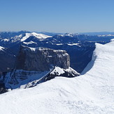
Le Mont Aiguille
Depuis le plateau du Vercors, Le Mont Aiguille
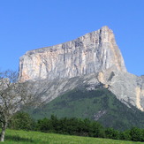
Mont Aiguille SE face
Mont Aiguille

