
– Lat/Long: 45.46° N 5.92° E
 Mont Granier
Weather Forecast, FranceIssued: 7 pm Tue 22 Apr Local TimeUpdates in: hr min sUpdate imminent
Mont Granier Weather Forecast, France
Issued: 7 pm Tue 22 Apr Local Time
Updates in:
Update imminent hr min s

Issued: 7 pm Tue 22 Apr Local Time
Updates in:
Update imminent hr min s
Days 1–4 Weather SummaryA light covering of new snow on Wed night turning to drizzle on Thu afternoon. Freeze-thaw conditions (max 5°C on Fri afternoon, min -1°C on Wed night). Wind will be generally light. | Days 5–7 Weather SummaryMostly dry. Mild temperatures (max 6°C on Mon afternoon, min 2°C on Sun morning). Wind will be generally light. | ||||||||||||||||||
Wednesday 23 | Thursday 24 | Friday 25 | Saturday 26 | Sunday 27 | Monday 28 | ||||||||||||||
night | AM | PM | night | AM | PM | night | AM | PM | night | AM | PM | night | AM | PM | night | AM | PM | night | |
rain shwrs | rain shwrs | light snow | snow shwrs | some clouds | rain shwrs | rain shwrs | clear | clear | clear | some clouds | cloudy | light rain | cloudy | rain shwrs | rain shwrs | clear | rain shwrs | rain shwrs | |
km/h | |||||||||||||||||||
 |  |  |  |  |  |  | |||||||||||||
— | — | 1.0 | 8 | — | — | — | — | — | — | — | — | — | — | — | — | — | — | — | |
0.4 | 0.1 | 0.1 | — | — | 0.5 | 0.2 | — | — | — | — | — | 0.1 | — | 0.1 | 0.1 | — | 0.3 | 0.3 | |
max°C | 4 | 2 | 3 | -1 | 1 | 2 | 2 | 2 | 5 | 5 | 3 | 4 | 3 | 3 | 4 | 5 | 4 | 6 | 6 |
min°C | 2 | 2 | 2 | -1 | -1 | 2 | 1 | 1 | 4 | 4 | 3 | 4 | 3 | 2 | 3 | 4 | 4 | 6 | 6 |
2 | 1 | -3 | -6 | -6 | -1 | -4 | -5 | 0 | 1 | 3 | 3 | 0 | 0 | 2 | 2 | 4 | 6 | 6 | |
2400 | 2400 | 2250 | 1800 | 2050 | 2450 | 2350 | 2500 | 3000 | 3200 | 2800 | 2700 | 2550 | 2400 | 2600 | 2750 | 2750 | 2850 | 3000 | |
Cloud base (m) | 2200 | 750 | 1500 | 600 | 950 | 1700 | 1950 | 1800 | 2150 | 700 | 1600 | 1950 | 2250 | 1800 | 2250 | 2100 | |||
— | 6:37 | — | — | 6:35 | — | — | 6:35 | — | — | 6:33 | — | — | 6:31 | — | — | 6:30 | — | — | |
— | — | — | 8:30 | — | — | 8:32 | — | — | 8:34 | — | — | 8:35 | — | — | 8:37 | — | — | 8:37 | |
Loading...
Mont Granier Weather (Days 0-3):
The weather forecast for Mont Granier is: A light covering of new snow on Wed night turning to drizzle on Thu afternoon. Freeze-thaw conditions (max 5°C on Fri afternoon, min -1°C on Wed night). Wind will be generally light.
Mont Granier Weather (Days 3-6):
Mostly dry. Mild temperatures (max 6°C on Mon afternoon, min 2°C on Sun morning). Wind will be generally light.
This table gives the weather forecast for Mont Granier at the specific elevation of 1933 m. Our advanced weather models allow us to provide distinct weather forecasts for several elevations of Mont Granier. To see the weather forecasts for the other elevations, use the tab navigation above the table. For a wider overview of the weather, consult the Weather Map of France.
| Weather Station | Temp. | Weather | Wind | Gusts | Cloud / Visibility |
|---|---|---|---|---|---|
TMX clos giraud g2 | |||||
TC Montfrais g4 | |||||
Aéroport Grenoble-Isère Grenobl / aint Geoirs Airport | |||||
Haute-Savoie Mont Blanc Airpor / éroport Annec / eythet | |||||
Aéroport Annecy Haute-Savoie Mont Blanc (Meythet) | |||||
Depart Geant | |||||
Eclipse | |||||
ChaletInter | |||||
Arrivee |
* NOTE: not all weather observatories update at the same frequency which is the reason why some locations may show data from stations that are further away than known closer ones.
Mont Granier Photos
View all
Chartreuse Mountains photos (2) |
Alps photos (1456) |
photos from mountains in France (280) |
all photos
 Upload new photo
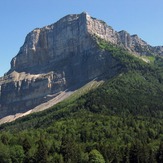
Mont Granier

