– Lat/Long: 45.53° N 6.87° E
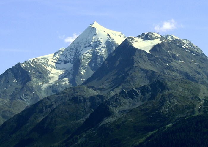
 Mont Pourri
Weather Forecast, FranceIssued: 7 pm Sat 13 Sep Local TimeUpdates in: hr min sUpdate imminent
Issued: 7 pm Sat 13 Sep Local Time
Updates in:
Update imminent hr min s

Issued: 7 pm Sat 13 Sep Local Time
Updates in:
Update imminent hr min s
Days 1–4 Weather SummaryA light covering of new snow mostly falling on Sat night. Freeze-thaw conditions (max 2°C on Sun night, min -5°C on Sat night). Mainly fresh winds. | Days 5–7 Weather SummaryMostly dry. Freeze-thaw conditions (max 5°C on Wed night, min -1°C on Tue night). Winds decreasing (fresh winds from the WNW on Tue night, light winds from the WNW by Fri afternoon). | ||||||||||||||||||
Sunday 14 | Monday 15 | Tuesday 16 | Wednesday 17 | Thursday 18 | Friday 19 | ||||||||||||||
night | AM | PM | night | AM | PM | night | AM | PM | night | AM | PM | night | AM | PM | night | AM | PM | night | |
mod. snow | light snow | some clouds | some clouds | clear | clear | clear | clear | some clouds | some clouds | some clouds | clear | clear | clear | clear | clear | clear | clear | clear | |
km/h | |||||||||||||||||||
 |  |  |  |  |  |  | |||||||||||||
6 | 2 | — | — | — | — | — | — | — | — | — | — | — | — | — | — | — | — | — | |
— | — | — | — | — | — | — | — | — | — | — | — | — | — | — | — | — | — | — | |
max°C | -3 | -3 | 0 | 2 | 2 | 1 | 0 | -1 | -1 | 0 | 2 | 4 | 5 | 5 | 4 | 5 | 5 | 5 | 5 |
min°C | -5 | -5 | -1 | 0 | 2 | 1 | -1 | -2 | -1 | -1 | 1 | 3 | 4 | 5 | 4 | 4 | 4 | 5 | 4 |
-11 | -13 | -8 | -6 | -3 | -4 | -8 | -9 | -8 | -8 | -5 | -2 | 0 | 2 | 1 | 1 | 2 | 3 | 4 | |
3100 | 3350 | 3700 | 4100 | 4050 | 3950 | 3650 | 3600 | 3600 | 3650 | 4200 | 4450 | 4600 | 4550 | 4450 | 4450 | 4400 | 4500 | 4450 | |
Cloud base (m) | 2250 | 2000 | 3350 | 3400 | 2000 | 4900 | 3550 | 4400 | |||||||||||
— | 7:07 | — | — | 7:09 | — | — | 7:11 | — | — | 7:11 | — | — | 7:13 | — | — | 7:13 | — | — | |
— | — | 7:45 | — | — | 7:45 | — | — | 7:43 | — | — | 7:40 | — | — | 7:38 | — | — | 7:37 | — | |
Loading...
Mont Pourri Weather (Days 0-3):
The weather forecast for Mont Pourri is: A light covering of new snow mostly falling on Sat night. Freeze-thaw conditions (max 2°C on Sun night, min -5°C on Sat night). Mainly fresh winds.
Mont Pourri Weather (Days 3-6):
Mostly dry. Freeze-thaw conditions (max 5°C on Wed night, min -1°C on Tue night). Winds decreasing (fresh winds from the WNW on Tue night, light winds from the WNW by Fri afternoon).
This table gives the weather forecast for Mont Pourri at the specific elevation of 3779 m. Our advanced weather models allow us to provide distinct weather forecasts for several elevations of Mont Pourri. To see the weather forecasts for the other elevations, use the tab navigation above the table. For a wider overview of the weather, consult the Weather Map of France.
Mont Pourri Photos
View all
Graian Alps photos (54) |
Alps photos (1476) |
photos from mountains in France (297) |
all photos
 Upload new photo
Mont Pourri